This item has been sold, but you can get on the Waitlist to be notified if another example becomes available, or purchase a digital scan.
1575 Braun and Hogenberg View / Map of Damascus
Damascus-braunhogenberg-1575$1,150.00

Title
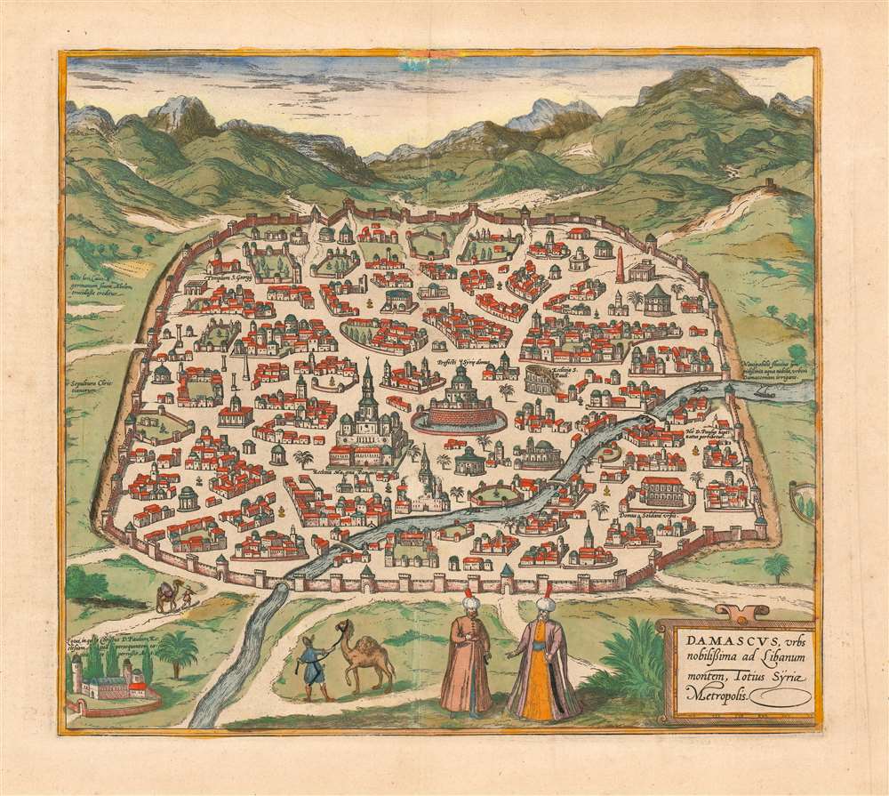
Damascus, urbs noblissima ad Libanum montem, Totius Sÿriae Metropolis
1575 (undated) 12.5 x 14 in (31.75 x 35.56 cm)
1575 (undated) 12.5 x 14 in (31.75 x 35.56 cm)
Description
This is a superb example of the 1575 view of Damascus, produced by Braun and Hogenberg for inclusion in the second volume of their Civitates Orbis Terrarum, the first dedicated city book. The beautifully engraved view, illuminated with superb original color, is one of the earliest printed views of Damascus. It depicts the contemporaneous Muslim walled city; its mosques are prominently shown. Some churches illustrated as well, though one of these, The Church of Saint Paul, is in ruins. In the foreground, two noblemen in Ottoman styles converse; two footmen can be seen leading camels.
Publication History and Census
This view appeared in the second volume of the Civitates in 1575, and it was included in all four subsequent editions with no changes. The Latin city books are well represented in institutional collections, but French editions appear to be scarce and are poorly catalogued.CartographerS
Georg Braun (1541 – March 10, 1622) was a German deacon, viewmaker, and typo-geographer based in Cologne. Along with Franz Hogenberg (1535 - 1590), Braun is best known for his publication of the highly influential city atlas Civitates Orbis Terrarum. The six volume work, with some 546 views, was published between 1572 and 1617 and intended a companion to Abraham Ortelius' Theatrum Orbis Terrarum - thus certain obvious stylistic similarities. In compiling the Civitates Braun took on the role of editor while most of the engraving work was completed by Franz Hogenberg. Braun died, as he was born, in Cologne. More by this mapmaker...
Franz Hogenberg (1535 - 1590), often called 'Master Franz,' was a Flemish engraver active in the late 16th century. Hogenberg was born in Mechelen, the son of Nicolas Hogenberg, where he trained under the cartographer H. Terbruggen. He later relocated to Antwerp where he achieved success as an engraver, working with Abraham Ortelius, Hieronymus Cock, and others. In 1568, his name appeared on the list of those banned from the Netherlands by the Duke of Alva, forcing his family to flee to London. There he engraved for Christopher Saxon's Atlas of England and Wales. By 1570 he emigrated to Germany settling in Cologne. In Cologne he married his second wife, Agnes Lomar, with whom he had six children. In 1579 the couple were briefly imprisoned for holding illicit secret religious meetings, but were released in short order. Along with German cleric George Braun (1541 – March 10, 1622), Hogenberg issued the highly influential city atlas Civitates Orbis Terrarum. The six volume work, with some 546 views, was published between 1572 and 1617 and intended a companion to Abraham Ortelius' Thatrum Orbis Terrarum - thus certain obvious stylistic similarities. In compiling the Civitates Hogenberg took on the role of engraver while most of the editing was left to Georg Braun. Hogenberg died in Cologne, Germany, before the Civitates was completed. After his death, Hogenberg's work was continued by his son, Abraham Hogenberg, who, under the direction of Agnes, his mother, took over his father's enterprise at just 20. Learn More...
Source
Braun, G. and Hogenberg, F. Civitatus Orbis Terrarum, 1575.
The Civitatus Orbis Terrarum is an 6-volume atlas of cities, or town book, compiled and written by George Braun, Canon of Cologne Cathedral and Franz Hogenberg. Braun and Hogenberg gathered together vast amounts of information and draft plans to produce over 500 city views/maps published in six parts between 1572 and 1617. Most of the town views and plans were engraved by Simon van den Neuvel (Novellanus) and Frans Hogenberg, many after drawings by Joris Hoefnagel. The Civitatus Orbis Terrarum was printed in Cologne, but in the Flemish style after Abraham Ortelius, the preeminent cartographer of the period. The text throughout is the work of Braun. The work proved to be a great success, reflecting the period's greater fascination with notable metropolises than with national boundaries. After the initial publication of volume 1, the popularity of the led to a second volume. In the introduction to volume 2, Braun requests that those who live in cities not represented, sent details of their own metropolises. This led to the publication of volumes 3, 4, and 5. Volume 6, the last, did not appear until 1617 under Franz Hogenberg's son, Abraham Hogenberg. The volumes include
- Civitates orbis terrarium, first edition 1572.
- De praecipuis, totius universi urbibus, liber secundus, first edition 1575.
- Urbium praecipuarum totius mundi, liber tertius, first edition 1581.
- Urbium praecipuarum totius mundi, liber quartus, first edition 1588.
- Urbium praecipuarum mundi theatrum quintum, first edition 1596.
- Theatri praecipuarum totius mundi urbium liber sextus, first edition 1617.
Condition
Excellent condition.
References
Rumsey 12126.000. OCLC 707613523. Fussel, Cities of the World pp192-93. Taschen p. 194.