This item has been sold, but you can get on the Waitlist to be notified if another example becomes available, or purchase a digital scan.
1624 Ortelius View of The Paradise of Daphne (Antioch)
Daphne-ortelius-1624$350.00

Title
Daphne.
1624 (dated) 14 x 18.75 in (35.56 x 47.625 cm)
1624 (dated) 14 x 18.75 in (35.56 x 47.625 cm)
Description
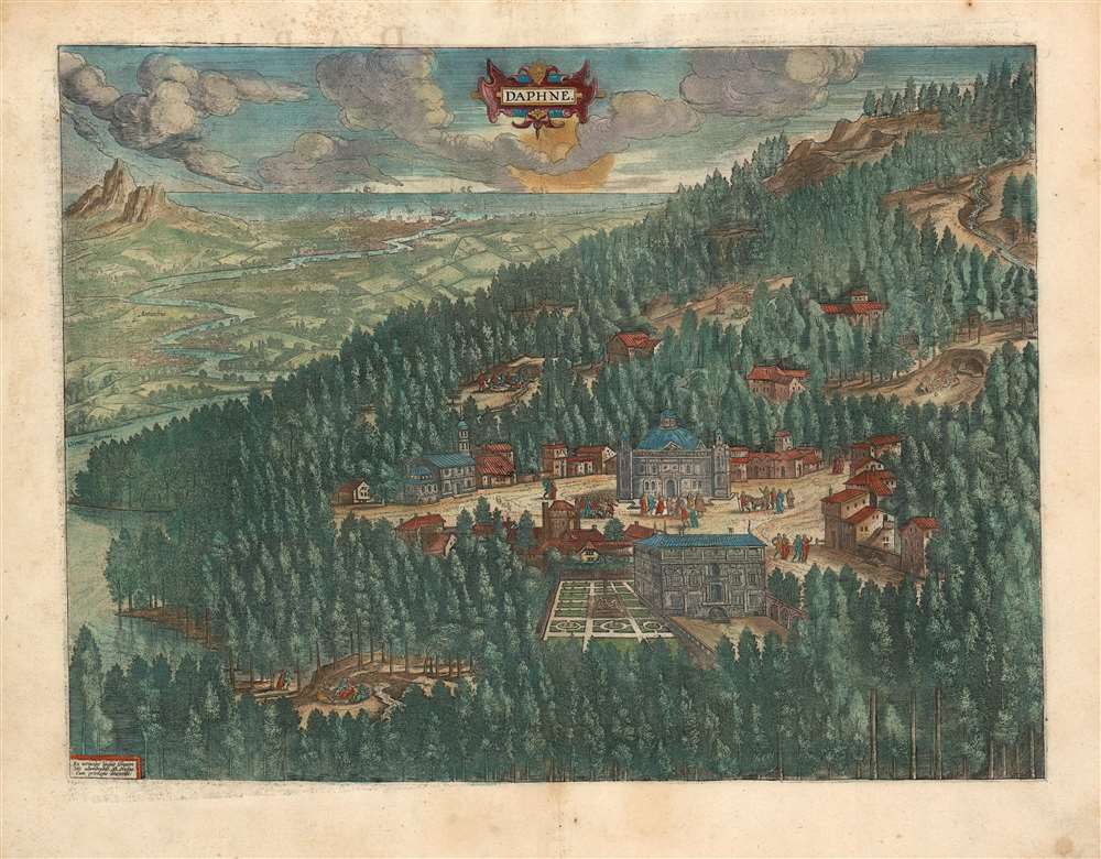
This is a lush example of Ortelius' 1595 engraving of the wooded parks and stately temples of Daphne, a classical paradise. At center is the temple to the Pythian Apollo: not visible here is Diocletian's companion sanctuary to Hecate, constructed (appropriately) underground. Four freshwater springs can be seen in clearings in the woods, with revellers taking the waters, dancing, playing music, drinking, and embracing, a hint given by the straitlaced Flemish engraver of the loose morals for which Daphne had unjustly become (in)famous.
The Myth
A slighted Eros had shot the god Apollo with a gold arrow to make him love the nymph Daphne, and had likewise shot Daphne with a lead arrow to make her hate Apollo. Divine arrows notwithstanding, Daphne, had chosen perpetual virginity, and fled Apollo's advances. Her river god father transformed her into a laurel tree to spare her the amorous intentions of Apollo, who had to make do with declaring the laurel tree sacred, wearing laurel in his hair and making his arrows from her limbs. Audiences contemporary to both the story's classical recounters and Ortelius interpreted this tale as a love story in a way that a modern audience might not. Considering what Apollo's father got up to, it is not hard to assume the apple didn't fall far from the tree.Fixing Paradise In Place
As with his view of Tempe, Ortelius made a point of showing that this legendary locale was an actual place in the physical world. In the distance can be seen the cities of Antioch and Seleucia with the river Orontes winding into the distance and emptying into the Mediterranean Sea.By the Hand of the Master
Ortelius's depiction, drawn primarily from classical historical and literary sources such as Ammianus, Strabo and Philostratus, is remarkable in being one of the engravings entirely his own work. While Ortelius was notable for his assiduous presentation of the best available contemporary geographical sources, he relied on his own composition when it came to the maps and views pertaining to ancient history, biblical history and classical myth.Publication History and Census
This engraving was first printed in 1595 to be included both in Ortelius' Parergon and in his Theatrum Orbis Terrarum. This example appeared in the final, 1624 edition of the Theatrum published by Balthazar Moretus. Ortelius' atlas is well represented in institutional collections.Cartographer
Abraham Ortelius (April 14, 1527 - June 28, 1598) also known as Ortels, was a cartographer, geographer, and cosmographer of Brabant, active in Antwerp. He was the creator of the first modern atlas, Theatrum Orbis Terrarum and is a seminal figure in the history of cartography. Along with Gerard Mercator and Gemma Frisius, he was a founder of the Netherlandish school of cartography. His connections with Spain - culminating in his 1575 appointment as Royal Cartographer to King Phillip II of Spain - gave him unmatched access to Spanish geographical knowledge during a crucial period of the Age of Discovery. Ortelius was born in 1527 in Antwerp. In 1547 he entered the Antwerp Guild of Saint Luke as an illuminator of maps. He began trading in books, prints, and maps, traveling regularly to the Frankfurt book and print fair, where in 1554 he met Mercator. He accompanied Mercator on journeys throughout France in 1560 and it was at this time, under Mercator's influence, that he appears to have chosen his career as a scientific geographer. His first published geographic work appeared in 1564, an eight-sheet cordiform world map. A handful of other maps preceded the 1570 publication of the first edition of the Theatrum Orbis Terrarum, which would prove to be his life work. Appearing with but 53 maps in its first edition, Ortelius' work expanded with new maps added regularly. By 1592, it had 134 maps. Many of Ortelius' maps remained the standard for nearly a century. He traveled extensively, but his genius was as a compiler, locating the best informed maps on which to base his own. His contacts throughout Europe and extending even (via the Portuguese) to the Far East were formidable. Moreover, many of his maps were based on his own scholarship, particularly his historical works. His theories of geography were particularly ahead of his time with respect to the notion of continental drift, the possibility of which he mused on as early as 1596, and which would be proven correct centuries later.
In a sense his greatest achievement was his successful navigation of the religious and political violence endemic to his city throughout his adult life: The Dutch Revolt, or Eighty Years' War (1568 - 1648), fully embroiled Antwerp. Although outwardly and officially recognized as Catholic (Arias Montanus vouched for Ortelius' Catholic orthodoxy prior to his appointment as Royal Geographer), Ortelius was able to separate himself from the religious furor which characterized the war in the low countries. Ortelius showed a glimpse of himself in a letter to a friend, regarding humanist Justus Lipsius: 'I do not know whether he is an adherent of the Pope or a Calvinist, but if he has ears to hear, he will neither be one nor the other, for sins are committed on both sides'. Ortelius' own explorations of Biblical history in his maps, and the Christogram contained in his own motto, suggest him to be a religious man, but his abjuration of political religious authorities mark him as an individualist. His tombstone at St Michael's Præmonstratensian Abbey in Antwerp bears the inscription, Quietis cultor sine lite, uxore, prole. ('served quietly, without accusation, wife, and offspring.') More by this mapmaker...
Source
Ortelius, A., Theatrum Orbis Terrarum, (Antwerp) 1624.
Abraham Ortelius' magnum opus, Theatrum Orbis Terrarum, was the world's first regularly produced atlas, which 'set the standards for later atlases . . . It was the first undertaking of its kind to reduce the best available maps to an uniform format.' (Koeman) A modestly-sized work of fifty-three maps in its first edition of May 1570, it was an immediate success: there were three further editions that year, and the work remained in print for a total of 32 editions, the last of which was 1641, well after its author's 1598 death. Ortelius added to his atlas constantly, and by 1595 the Theatrum contained 147 maps. Ortelius is renowned generally as an editor, and indeed much of the Theatrum is compiled from a variety of sources: in such cases, Ortelius was scrupulous in naming his sources. But Ortelius was also a mapmaker in his own right: many of his maps are a distillation of various sources into his own work, and there were many maps - particularly in his atlas of Biblical and ancient history Parergon - which were entirely Ortelius' work. In his role as an editor, Ortelius followed in the footsteps of Munster, whose Cosmographia was, until Ortelius, the best window on the world for the curious European reader. In terms of the artistry of his maps, Ortelius oversaw the first great flourishing of copperplate engraving in the service of cartography to occur in Northern Europe. Ortelius' work provided the model for the atlases of Mercator, Hondius, Blaeu and all their progeny in the 17th century - many of whom were to produce faithful editions of Ortelius' maps in their own productions.
Condition
Excellent condition. Fine hand color; generous margins.
References
OCLC 864277219. van den Broecke 232.