This item has been sold, but you can get on the Waitlist to be notified if another example becomes available, or purchase a digital scan.
1821 Qing Chinese Qianren Huang Map of China
DaQing-qing-1821$30,000.00

Title
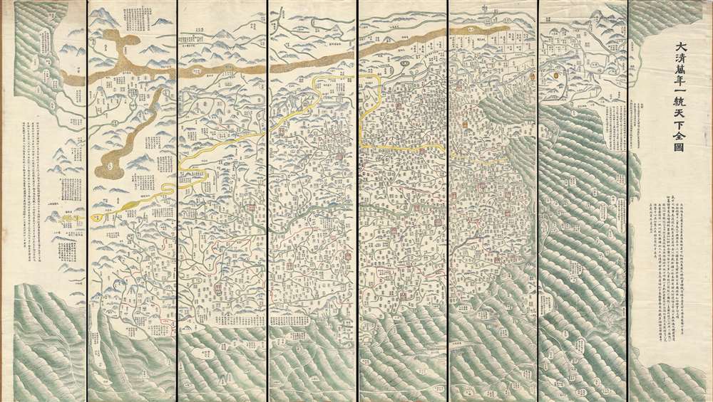
DaQing Wannian Yitong Tianxia Quantu / 大清万年一统天下全图 / All-Under-Heaven Complete Map of the Everlasting Unified Qing Empire
1821 (undated) 55 x 98 in (139.7 x 248.92 cm) 1 : 2500000
1821 (undated) 55 x 98 in (139.7 x 248.92 cm) 1 : 2500000
Description
A seminal 1821 (Daoguang 1) Qing Dynasty Chinese map of utmost importance and rarity, this is Huang Qianren's (黃千人, 1694–1771) grand and spacious map of the Great Qing Empire of China. Although ostensibly a map of China, the coverage of this map in fact extends to all lands touched by the influence Qing Empire, including England, Holland, Southeast Asia, and Africa. As such it can be considered a political manifesto lionizing the unity and majesty of Qing China as well as a functional administrative document. This edition of the map, 1821, was issued to memorialize the reign of the Jiaqing Emperor and celebrate the coming Daoguang reign.
The map was reintroduced in manuscript form by Huang Zhengsun in the year 1800 to memorialize the Qianlong Emperor's life and celebrate the coming reign of the Jiaqing Emperor. The 1800 manuscript issue exists in only one example at the Beijing National Library. Afterwards, revised woodblock printings and rubbings were issued to celebrate important moments in the expansion of Qing influence. We are aware of an 1806 printed edition, for example, which we sold previously, and which is the earliest known printed version of this map. The famous blue rubbing edition was published only in 1811. The present printed map was also issued in 1821.
This map typically appears in 8 separate panels. Some examples are joined as a single map, others are mounted on scrolls in traditional Chinese fashion. The present example is offered in separate sheets. Evidence of old mounting is present, but the maps are now separate panels. In our experience this is one of the finest examples of the printed versions of this map to appear on the market.
Tianxia Quantu Map Series
This series of Qing maps, generally referred to as Tianxia Quantu, dominated Chinese cartography throughout the Jiaqing Reign (1760 – 1820) and persisted well into the reign of the Daoguang Emperor (1820 – 1850) – for which the current example was issued. The term Tianxia Quantu refers to that portion of the title that most eloquently summarizes their underlying purpose as 'unified under heaven,' heaven being Qing China.The Map's History
Huang Qianren based this map upon an earlier map (天下舆图) by his grandfather, the Chinese enlightenment master Huang Zongxi (黄宗羲) (1610 - 1695), which he updated and expanded with additional detail and coverage including Jinchuan (part of modern day Sichuan), Tibet, and Xinjiang. Unfortunately no examples of the initial issue survive.The map was reintroduced in manuscript form by Huang Zhengsun in the year 1800 to memorialize the Qianlong Emperor's life and celebrate the coming reign of the Jiaqing Emperor. The 1800 manuscript issue exists in only one example at the Beijing National Library. Afterwards, revised woodblock printings and rubbings were issued to celebrate important moments in the expansion of Qing influence. We are aware of an 1806 printed edition, for example, which we sold previously, and which is the earliest known printed version of this map. The famous blue rubbing edition was published only in 1811. The present printed map was also issued in 1821.
A Tribute System Encompassing the Known World
An initial examination of the easily recognizable portions of the map suggests an expansive coverage extending from Siberia to Borneo and from India to Korea. Closer examination reveals that this is in fact a map of the world, scaled not in terms of distance, but rather in terms of degree of subjugation to and importance to Qing China. The map is read, like traditional Chinese texts, from right to left, with the most densely detailed regions corresponding to the eastern shores of China. At the far west, in the distant upper left corner, European countries like Holland, Portugal (Land of the Great Western Sea), possibly Italy, Arabia (Homeland of Islam), Africa (Land of the Black Ghosts), the Mediterranean (Little Western Sea), and even the Atlantic (Great Western Sea) are identified. Surrounding the map are textual annotations describing the subject peoples of various regions. The annotations identify not only the people, but the great distances their leaders travel, the great hardships they endure, and the gratefulness with which they suffer, to pay tribute to the mighty and culturally superior Qing.Ceremonial Embodiment of Qing Rule
Thus the map takes on meaning as a ceremonial and administrative embodiment of Qing rule and the tribute system. The Manchu Qing were a nomadic people who did not visualize themselves limited by geo-political boundaries – and aptly there are none on this map – rather, their territorial dominion extended to wherever they exerted influence, and the significance of all other lands correspondingly diminished or increased according to that influence. A noted by Richard Pegg,This 'complete' map minimizes the European notion of a map of the world, its centralized and marginalizing construct confirm the Qing / Chinese notion of the Central Kingdom (Pegg, R., Cartographic Traditions in East Asian Maps p. 19).
Understanding the Map
A key to the right of the map helps to understand the map and identify its iconography. Although the translations are our own we are indebted to Richard Pegg, see above, for helping to define the administrative terminology.- Sheng – provincial capital – square topped by a rectangle.
- Fu – prefecture – a square.
- Ting – sub-prefecture –oval.
- Zhilizhou – independent magistrate – small house with triangle roof.
- Zhou – department – rectangle.
- Xian – district – circle.
- Guan – frontier station – shaped like a small house. In the key on most issues, this icon is missing a roof, but the roofs are present on the map. This omission was corrected in the 1811 blue issue, but not the 1811 printed issue, or in subsequent printed issues, as seen here.
- Guanzhen – meaning unclear – double circle.
- Tusi – indigenous official.
Publication History and Census
Although others may yet be discovered, there currently several known variants of this map. The differences between editions tend to be related to printing technique and changes to the far left and right panels. The far left panel, dealing with border provinces and bearing imprint text, is the one most commonly changed- 1767 Huang Qianren – no surviving examples.
- 1800 Manuscript – 1 surviving example in Beijing National Library.
- 1803 Woodcut Printing – 1 Surviving example.
- 1806 Woodcut Printing – 1 Surviving example.
- 1811 Rubbing - Blue Map (also in black, green, and possibly red)
- 1814 Woodcut Printing - Private collection.
- 1821 Woodcut Printing - Library of Congress – Present Example.
- 1883 Manuscript, Private Collection.
This map typically appears in 8 separate panels. Some examples are joined as a single map, others are mounted on scrolls in traditional Chinese fashion. The present example is offered in separate sheets. Evidence of old mounting is present, but the maps are now separate panels. In our experience this is one of the finest examples of the printed versions of this map to appear on the market.
Cartographer
Qianren Huang (黃千人, 1694 – 1771) was a Chinese cartographer active 18th century during the reign of the Qianlong Emperor. He was born in Yuyao, Zhejiang, China. He passed the state civil service exam for Tai-an and was awarded a position as a clerk. His grandfather was the great Qing Chinese polymath and 'Father of the Chinese Enlightenment' Huang Zongxi (黄宗羲) (1610-1695), father of Huang Baijia (黃百家) (1643-1709). He is best known for his 1767 revision of Huang Zongzi's map 天下舆图, published as DaQing Wannian Yitong Tianxia Quantu (大清万年一统天下全图)or All-Under-Heaven Complete Map of the Everlasting Unified Qing Empire. More by this mapmaker...
Condition
Very good. In 8 sections. Light edge wear. Evidence of earlier mounting. Most panels have Russian writing on the back with one note identifing this as the 1821 edition.
References
Pegg, R., Cartographic Traditions in East Asian Maps, 17-27. Smith, R., Mapping China's World: Cultural Cartography in Late Imperial Times. Library of Congress, Map Division: AACR2: 650; 700/2. OCLC 5681862. National Library of Australia, 26550279.