This item has been sold, but you can get on the Waitlist to be notified if another example becomes available, or purchase a digital scan.
1943 Stanley Turner Map of Europe, Africa, and Asia During World War II
DatedEventsFifth-turner-1943$187.50

Title
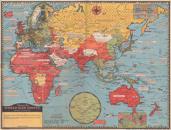
Map of the World War Fronts. Dated Events.
1943 (dated) 19.75 x 26 in (50.165 x 66.04 cm) 1 : 19500000
1943 (dated) 19.75 x 26 in (50.165 x 66.04 cm) 1 : 19500000
Description
This is a 1943 Stanley Francis Turner map of Europe, Asia, and Africa during World War II. The map depicts from the Atlantic Ocean to the International Date Line, the Aleutian Islands, and Midway Island in the Pacific Ocean and from the Arctic Ocean and the Barents Sea to Australia and New Zealand. As this is the fifth edition in Turner's 'Dated Events' series, this edition was published relatively early on in the war. Nonetheless, myriad text boxes throughout the map highlight recount critical events in the course of the war, from the Munich Agreement in September 1938 until the Battle of the Bismarck Sea in the Pacific, the recapture of Kharkov by the Nazis, and the Russian capture of Vyasma, all of which took place in March 1943. Turner traces events that took place between 1938 and 1943 throughout the map, including combat and diplomatic actions, from Casablanca to Honolulu, in Western Europe, Eastern Europe, North Africa, the Pacific. Through the use of various colors, which are explained in a legend located in the upper right corner, Turner tracks the geographical progress of Axis and Allied forces, illustrating which territory had been conquered by the Axis, and where the Allies had managed to reverse Axis victories and liberate conquered ground.
On a purely functional level, Turner's work is all-encompassing. Myriad cities and towns throughout depicted world are labeled, not only the capitals of each country (which are highlighted by yellow banners). The flags of almost every nation represented on the map are present, including the Free French flag in French Equatorial Africa, where De Gualle and the Free French began their fight against the Axis. Resources throughout the world are also indicated, such as oil and coal. Rivers, lakes, and roads, and railroads are illustrated, although the latter two appear to be confined to Asia and Australia. Ships and aircraft dot the seas and the skies and are 'painted' in camouflage, a measure taken by most militaries during the war. An inset map along the bottom border illustrates the distances between the world's major airports, with certain routes illustrated with distances included. Another inset map of the world on Mercator's projection is situated along the bottom border below Australia.
This map was created by Stanley Francis Turner and published by C. C. Peterson Publishing and Advertising in 1943.
Cartographer
Stanley Francis Turner (1883 – 1953) was a visual artist and painter based in Toronto, Canada. Turner was born in Aylesbury, England. He studied art in London at the South Kensington School before migrating to Canada in 1903, where he studied at Ontario College of Art under George Reid and J. W. Beatty. Turner is best known as a painter and designer capable of working in a variety of mediums. During World War II, Turner took a contract with the Globe and Mail to illustrate pictorial maps of war events. Turner may have maintained the rights to his war maps, as he also seems to have had a contract with the advertiser and publisher, C.C. Peterson, also of Toronto, to publish and distribute his maps in the United States. Turner's maps are information dense and designed to illustrate the events of the war in an easily digestible pictorial format. Turner experimented with different ways of working with the cartographic ranging from simple Mercator projections to more contemporary equal-area projections. In 1930, Turner was elected an Associate of the Royal Canadian Academy of Arts. He died in Toronto in 1953. More by this mapmaker...
Condition
Good. Backed on archival tissue for stability. Slight loss along original fold lines. Soiling, particularly along bottom border on left. Map of the Pacific Theater on verso.
References
OCLC 694518379.