This item has been sold, but you can get on the Waitlist to be notified if another example becomes available, or purchase a digital scan.
1944 Turner Pictorial Map of Europe Just After the D-Day Invasion of France
DatedWarMap7thEd-turner-1944-3$125.00

Title
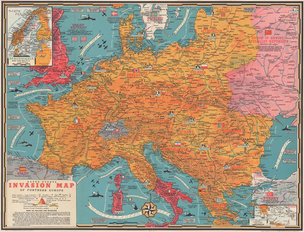
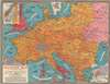
Dated Events Invasion Map of Fortress Europe. Seventh Edition.
1944 (dated) 20 x 26.25 in (50.8 x 66.675 cm) 1 : 5100000
1944 (dated) 20 x 26.25 in (50.8 x 66.675 cm) 1 : 5100000
Description
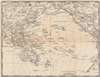
This is a 1944 Stanley Francis Turner pictorial map of Europe just after the D-Day invasion of France. This is the first edition of Turner's 'Dated Events War Map' series to depict the D-Day invasions, published only days after the landings in France.
D-Day
This edition must have been published only days after the D-Day invasion of France, which is referenced in a text box with 'INVASION' in block lettering. This is likely the first edition of Turner's 'dated war maps' to reference the D-Day invasion, since later editions shade the areas of France that had been liberated red.Invasion of Sicily and Italy
Much like how later editions depict the Allied advance across northern Europe, both Sicily and southern Italy are shaded red to highlight territory Allied armies had liberated. Dates are given for the liberation of Palermo in Sicily, the British landings on September 3, and the American landing at Salerno on September 9. The fortifications of the Gustav Line, which had stymied the Allied advance for months, are referenced as well. Curiously, Rome had been liberated on June 5, the day before the Normandy landings, but that monumental occasion is not illustrated here.The Eastern Front
The fighting on the Eastern Front is chronicled as well. The Nazi invasion of Poland is announced, as is their invasion of Russia almost two years later. Curiously, no other events of the Nazi drive across the Soviet Union are referenced, only Soviet victories in 1943 and 1944. A textbox along the top border announces the raising of the Leningrad siege in January 1943 and red stars mark Soviet victories and the date is provided, but no Soviet losses are to be found.Other Dated Events
Other events, such as the American declaration of war on Germany and Italy, the American arrival in Ireland, and the Operation Torch landings in North Africa are also referenced along the left border. Other events are marked where they occurred, such as the failed invasion at Dieppe.A Closer Look at the Map
Continental Europe occupies most of the sheet, with England and Wales illustrated in the upper left corner. Very faint markings establish pre-war borders, likely Turner's way of emphasizing the continental dominance of the Wehrmacht and Nazi Germany. Major European capitals, including London, Paris, Berlin, and Rome, are all labeled in blue block letters and highlighted by profile illustrations of famous landmarks, such as Big Ben in London and the Eiffel Tower in Paris. Fortifications, like the Siegfried Line, are marked by small icons of guns. Bomb icons mark cities in Germany and Holland that were subjected to Allied bombing raids, but only one such target is marked in France, Le Creusot, even though many other French cities were Allied targets. An inset map, entitled 'Scandinavia and the Baltic' is situated in the upper left corner and a second inset map in the lower right corner depicts southern Greece and the Dodecanese Islands.The Verso – The Pacific War
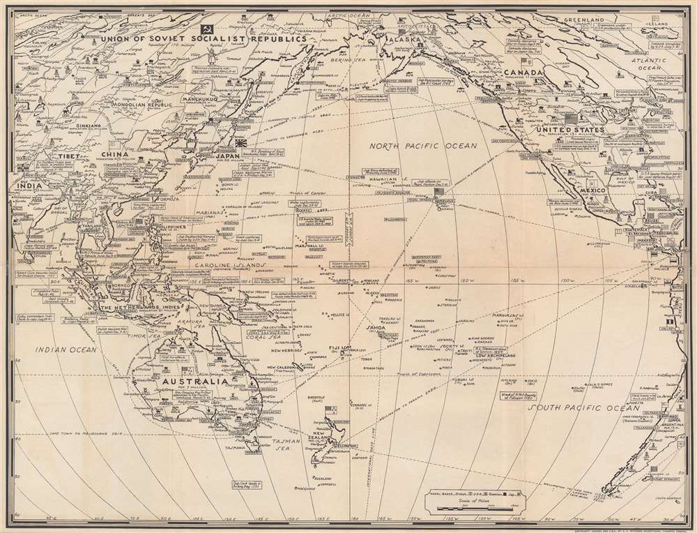
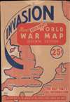
A black and white map printed on the verso recounts the events of the Pacific War. Turner uses the same aesthetic and employs textboxes to recount events in this theater of war from beginning with the Japanese attack on Pearl Harbor on December 7, 1941 through the capture of Madang on New Guinea in late-April 1944. The Doolittle Raid, the fall of Corregidor and Bataan, and the Battles of the Coral Sea and Midway are among the many historic moments highlighted here.Publication History and Census
This map was created by Stanley Francis Turner and published by C.C. Peterson in 1944. Four examples are catalogued in the OCLC and are part of the institutional collections at the Cleveland Public Library, Auburn University, the University of Memphis, and the National Library of Australia. Another example is part of the David Rumsey Map Collection at Stanford University.CartographerS
Stanley Francis Turner (1883 – 1953) was a visual artist and painter based in Toronto, Canada. Turner was born in Aylesbury, England. He studied art in London at the South Kensington School before migrating to Canada in 1903, where he studied at Ontario College of Art under George Reid and J. W. Beatty. Turner is best known as a painter and designer capable of working in a variety of mediums. During World War II, Turner took a contract with the Globe and Mail to illustrate pictorial maps of war events. Turner may have maintained the rights to his war maps, as he also seems to have had a contract with the advertiser and publisher, C.C. Peterson, also of Toronto, to publish and distribute his maps in the United States. Turner's maps are information dense and designed to illustrate the events of the war in an easily digestible pictorial format. Turner experimented with different ways of working with the cartographic ranging from simple Mercator projections to more contemporary equal-area projections. In 1930, Turner was elected an Associate of the Royal Canadian Academy of Arts. He died in Toronto in 1953. More by this mapmaker...
C. C. Peterson (fl. c. 1940 – 1950) was an advertising and publishing company based in Toronto Canada, but with distribution and licensing in both the United States and Canada. Peterson had contracts with the artist Stanley Francis Turner to publish pictorial 'war maps' during World War II. The company supplemented its income by selling advertisements on Turner's maps. Learn More...
Condition
Very good. Light wear and toning along original fold lines. Verso repairs to fold separations. Exhibits slight loss at central fold intersection. Map of Pacific War on verso. Accompanied by original sleeve.
References
OCLC 25904478. Rumsey 9838.001.