1968 National Park Service Raised Relief Map of Death Valley National Monument (Park)
DeathValley-natparks-1968$250.00

Title
Death Valley National Monument.
1968 (undated) 10.5 x 7.5 in (26.67 x 19.05 cm) 1 : 316800
1968 (undated) 10.5 x 7.5 in (26.67 x 19.05 cm) 1 : 316800
Description
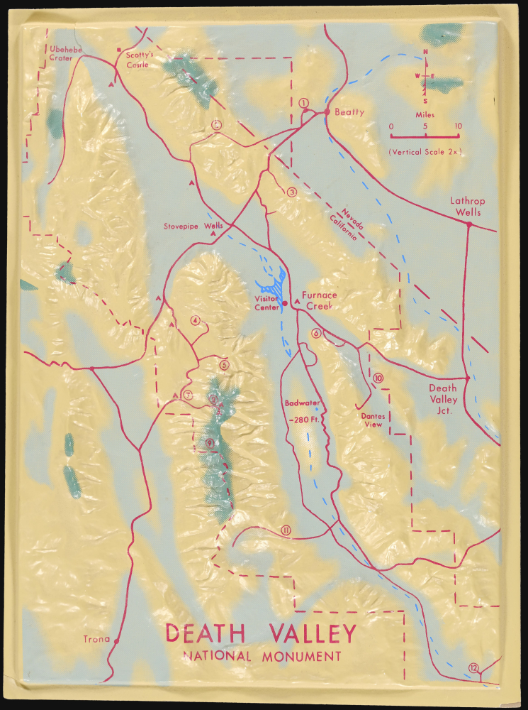
This is an unusual c. 1968 three-dimensional raised relief model of Death Valley National Monument (now a national park) along the California-Nevada border. It demonstrates the uniquely dramatic and harsh terrain of the region, where extreme temperatures at its lowest points (well below sea level) have led it to be dubbed 'the hottest place on earth.'
This model was most likely used for educational purposes and originated from the national monument itself. The U.S. Geological Survey had produced raised relief models from its early years in the late 19th century, and the National Park Service followed suit after its creation in 1916. The increased use of plastic and better production methods made the creation of such works much easier in the 20th century. Often these models were large and stationary, displayed permanently or semi-permanently in park visitors centers, but the present example is much more portable.
A Closer Look
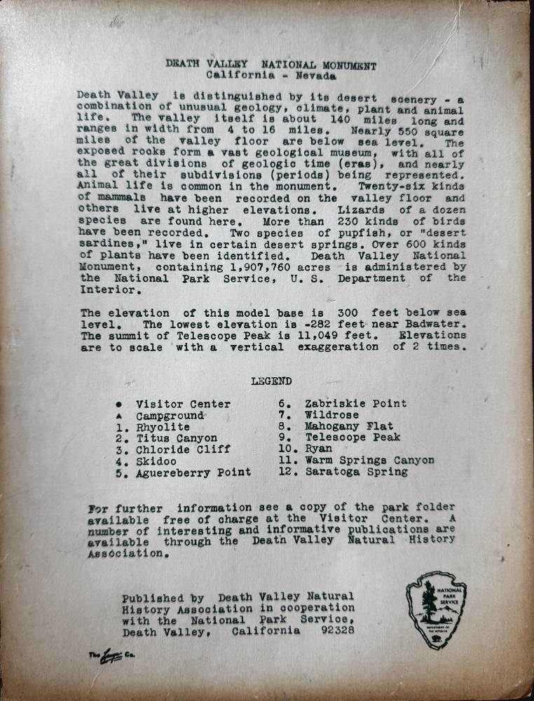
The model covers the national monument area in southeastern California and western Nevada, from Scotty's Castle, Rhyolite, and Beatty in the north to Trona and Saratoga Spring in the south. In addition to highways and larger towns, twelve locations are numbered on the model, corresponding to an index on the accompanying sheet. As the sheet explains, the plastic model expresses the drastic changes in elevation within the national monument area, from nearly 300 feet below sea level near Badwater to more than 11,000 feet at Telescope Peak, a mere 15 miles away. Additional geological, ecological, and historical information on the Death Valley region is included on the sheet.This model was most likely used for educational purposes and originated from the national monument itself. The U.S. Geological Survey had produced raised relief models from its early years in the late 19th century, and the National Park Service followed suit after its creation in 1916. The increased use of plastic and better production methods made the creation of such works much easier in the 20th century. Often these models were large and stationary, displayed permanently or semi-permanently in park visitors centers, but the present example is much more portable.
Death Valley National Park
On February 11, 1933, President Herbert Hoover created a nearly two-million-acre national monument in Death Valley. The Civilian Conservation Corps was responsible for the earliest improvements to the park, grading 500 miles of roads, installing telegraph and water lines, and constructing seventy-six buildings. Designated a biosphere reserve in 1994, Death Valley National Monument was expanded by 1.3 million acres on October 31, 1994, and redesignated as Death Valley National Park - the largest national park in the contiguous United States (larger than Rhode Island or Delaware and almost as large as Connecticut).Publication History and Census
This model was prepared by the Death Valley Natural History Association in conjunction with the National Park Service. The actual maker is indicated at bottom-left, but its name is difficult to discern; it may be the Lange Co., a Colorado-based firm that made ski shoes and other molded plastic ski equipment around the same time. The model is undated but was one of several such raised relief models of National Parks produced during the late 1960s, some of which (including the present work) are cataloged in the OCLC among the holdings of the University of California, Los Angeles.Cartographer
The National Park Service (August 25, 1916 - Present) is a United States government agency tasked with managing all national parks, most national monuments, and other historical, recreational, and natural properties. Part of the U.S. Department of the Interior, the Service oversaw 423 units in 2020, sixty-three of which were national parks, and employed over 12,500 people. More by this mapmaker...
Condition
Very good. Molded plastic mounted on paper.
References
OCLC 39631028.