1941 Hammond Pictorial Map of United States Defense Mobilization pre WWII
DefenseMobilization-hammond-1941-2$450.00

Title
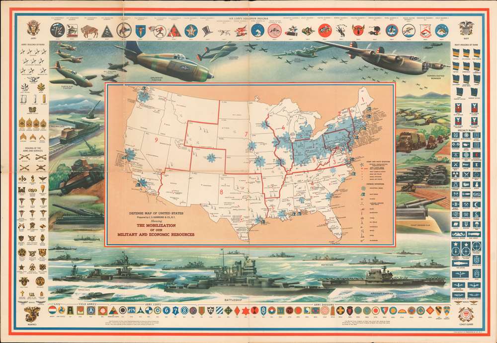
Defense Map of the United States Prepared by C.S. Hammond and Company, N.Y. Showing the Mobilization of our Military and Economic Resources.
1941 (undated) 22 x 32 in (55.88 x 81.28 cm) 1 : 11200000
1941 (undated) 22 x 32 in (55.88 x 81.28 cm) 1 : 11200000
Description
This is a c. 1941 C. S. Hammond and Company pictorial map of the United States highlighting the military and economic resources available on the brink of World War II. Blue-colored cogs highlight industrial areas around the country to illustrate the manufacturing might that could be brought to bear. Other defense industries are marked on the map by icons, including shipyards, factories for making planes, airplane engines, munitions, tanks, guns, steel, and aluminum. Army and navy bases are identified as well, as are army and navy airfields.
The Pictorial Border - A Show of Military Force
It is the pictorial border, however, that immediately draws the viewer's attention. The air, land, and sea forces of the United States military are put on full display, creating a forceful image that undoubtedly counts as propaganda and shouts 'support the military'. Cutting edge aircraft, such as the Boeing B-17 Flying Fortress, Consolidated B-24 Liberator, Lockheed P-38 Lightning, Grumman F4F Wildcat, and Curtiss P-40 Warhawk, are prominently illustrated along the map's top border. Tanks, artillery guns, howitzers, and supply trucks along the map's two sides represent ground forces.The Navy
Perhaps the most incredible part of this piece (with the benefit of hindsight of course) is the placement of the battleship front and center along the bottom border. The legendary naval engagements fought between the United States and Japan had not yet occurred, and naval strategists believed that the battleship, not the aircraft carrier, would be the key element to success on the world's oceans. An aircraft carrier appears to the right of the battleship, complete with its aircraft on the flight deck. A heavy cruiser steams to the battleship's left, surrounded by torpedo boats, light cruisers, destroyers, and submarines.Insignia
Illustrations of American Army and Navy insignia frame the entire piece, with army insignia on the left and navy insignia on the right. Army insignia of rank, from general to private first class, are situated at the top left, while insignia of 'arms and services', such as the infantry, ordnance department, signal corps, and medical corps, are on the bottom left. Naval insignia of rank are just opposite, on the top right, while naval specialty marks, such as sharpshooter, bugler, machinist's mate, and cook, are on the bottom right. A sample of Army and Navy Air Corps insignia are included along the top, while the insignia of army headquarters, field armies, army corps, and army divisions are along the bottom.Publication History and Census
This map was created by C.S. Hammond and Company and published c. 1941. The OCLC catalogues examples of this map as being part of fourteen institutional collections, but it is scarce on the private market.Cartographer
Caleb Stillson Hammond (1862 - 1929) was the founder of C. S. Hammond & Company, a map making and printing firm based in Brooklyn, New York. Hammond started his career in mapmaking as the head of Rand McNally's offices in New York City, where he began working in 1894. Hammond split with Rand McNally, forming his own printing concern in Brooklyn, New York, in 1900. The firm was subsequently incorporated in 1901 and relocated to Manhattan, and then to Maplewood, New Jersey, near Hammond's family home. Hammond rose to become one of the largest cartographic publishers in the United States, second only to Rand McNally in volume. On his retirement, C. S. Hammond passed the firm to his son, who subsequently passed it to his own son, C. D. Hammond, who sold the company to Langenscheidt Publishers in 1999. The firm has since been folded into Universal Map, an affiliate of Kappa Publishing Group. This archives of the Hammond World Atlas Corporation, an invaluable resource, where donated to the Library of Congress in 2002. More by this mapmaker...
Condition
Good condition. Exhibits wear along original fold lines, especially at fold intersection, where there are some verso reinforcements. Exhibits some toning.
References
Curtis, P. and J. Pedersen, War Map p. 132-33. Rumsey 8840.000. OCLC 66898853.