This item has been sold, but you can get on the Waitlist to be notified if another example becomes available, or purchase a digital scan.
1777 Rennell / Dury Wall Map of Delhi and Agra, India
DelhiAgrah-dury-1777$750.00

Title
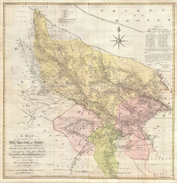
A Map of the Provinces of Delhi, Agrah, Oude, and Ellahabad, comprehending the Countries lying between Delhi, and the Bengal-Provinces, Surveyed by Major James Rennell, Surveyor General to the Honorable East-India Company, and Published by order of the Court of Directors of the said Company. By Andrew Dury, MDCCXXVII.
1777 (dated) 43 x 43 in (109.22 x 109.22 cm)
1777 (dated) 43 x 43 in (109.22 x 109.22 cm)
Description
An altogether spectacular wall sized map of those parts of India near Delhi, Agra and Varanasi. Covers from Delhi in the northwest as far east along the Ganges River as Bihar and as far south as Sohagepour. Includes Varanasi (Benares), Lucknow, Gorakhpur and Faizabad among many other important Indian cities. Bounded on the north by the Himalaya Mountains and the border with Tibet and Bhutan. One of the first accurate maps of the interior of India. Laid out from primary surveys done by James Rennell, the first modern cartographer to map the interior of India. Notes cities, markets, battlefields, fortresses, roads, rivers, offers political commentary, and features some geographical references. Elaborate title in the lower left quadrant. Upper right quadrant features a dedication and letter of thanks written by Andrew Dury, the publisher, to the board of the East India Company. This is the first edition of this rare map – 1777 – as published by Dury. Later editions were published by Sayer and Bennet and by Laurie and Whittle.
CartographerS
James Rennell (December 3, 1742 - March 29, 1830) was an English geographer, historian and seminal oceanographer, known as 'the Father of Indian Geography'. He would become, in 1830, one of the founders of the Royal Geographical Society in London. Rennell was born near Chudleigh in Devon, England. At 14 he joined the British Navy as a midshipman and served in the Seven Years' War. During his time in the Navy he mastered marine surveying; when his ship, HMS Grafton, saw service in India, he began lending his services to the East India company, accompanying hydrographer Alexander Dalrymple and drawing charts between 1759 and 1764. Following the Seven Years' War, seeing no prospect of advancement in the Navy he left the navy and joined the British East India company's sea service, where he continued survey work. Eventually he would be commissioned with the Bengal Engineers, and his surveys in India proper began in earnest. He would become surveyor-general for the EIC in Bengal, remaining in service until 1777. He would retire from active duty with the rank of Major in the Bengal Engineers. From London, he published extensively: his 1779 Bengal Atlas, and his 1783 map of India set the standard for the mapping of the subcontinent. He set his career to paper in the 1788 book Memoir of a map of Hindoostan. More by this mapmaker...
Andrew Dury (fl. 1742 - 1778) was a London based engraver, map publisher, and map seller working in the mid to late 18th century. Little is known of Dury's life. Hw was likely born in Ireland, but spent considerable time in Paris until about 1754. He first appeares in Dublin in 1754, possibly in the company of John Rocque (1704 - 1762), which whom he is closely associated. At that time he advertised himself as an engraver 'Late of Paris'. His imprint often appears on the work of a number of prominent London publishers from Sayer and Bennet to Laurie and Whittle and Gentlemans' Magazine. Learn More...
Source
The Bengal Atlas ??, Rennell, James, (1779 first edition)
Condition
Very good condition. Four sheets joined. Full professional restoration. Margins added. Backed with heavy linen.
References
Rumsey 2310.066 (later editon). National Library of Australia, 3422762. Pierce, B., A Catalogue of the Library of Harvard University in Cambridge, Massachusetts..., page 172. OCLC 7160203. Cf Phillips, 699. Shirley R., Maps in the atlases of the British Library, T.LAU-1c (1799 ed.). NMM 375 (3rd ed. 1801)