1247 Huang Shang 'Dili Tu' Map of China - earliest Map of China!
DiliTu-huangshang-1247$250,000.00


Title
Dili tu. / 墬理圖
1247 (undated) 72 x 39.5 in (182.88 x 100.33 cm)
1247 (undated) 72 x 39.5 in (182.88 x 100.33 cm)
Description
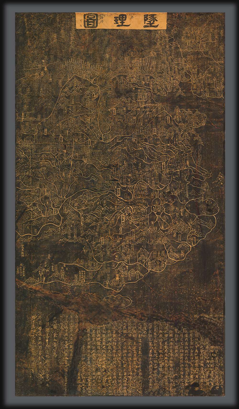
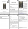
An outstanding discovery, this is the legendary c. 1247 Dili tu (墬理圖) terrestrial map of China. This is the earliest surviving example of one of the earliest known maps of China produced in the Common Era. The map was drawn by the Chinese polymath Huang Shang (黃裳). Huang's original wood carving, produced around 1194, has long been lost, but the map was engraved in stone in 1247 by Wang Zhiyuan (王致遠). This rubbing comes from that stone and dates to sometime between 1493 and 1602 - making it the oldest known extent rubbing of the Dili tu of China. The present map has been carbon-dated as having been created between 1493 and 1602, with supplementary ink testing verifying the results (these documents are available upon request and accompany the item).
The map illustrates 368 prefectures, 623 military bases, 73 rivers, 27 lakes, 180 mountains, and 24 passes, but refrains from delineating state or national boundaries - thus presenting China as a cohesive whole. The map presents an aspirational, undivided vision of China, extending from the Great Wall and Manchuria to Hainan Island. (Taiwan may be present as an unlabeled mountain off the east coast of China in roughly the correct position.) It was an object lesson for the young Emperor - this is what China was under your ancestors and what it must be again. Period reports identified three educational maps that traveled with the Emperor: this map, a terrestrial chart, and a third urban plan, possibly of the city of Suzhou.
Like many Chinese maps, the present one is presented not just as a geographical document but as an education in history. As Yee points out, the Dili tu shows the capitals of the Northern Song (960 - 1126) and Liao dynasties, both of which had been lost to the Jin. Elsewhere, a note mentions Guangwudi (r. 25 - 57), restorer of the Han dynasty (206 BC - 220 CE). By highlighting the losses of previous rulers, the map was intended to educate the new ruler on the extent of his lands, encourage the expansions he should undertake, and instill reverence for his forbears.
该地图绘有368个州府、623座军事要塞、73条河流、27个湖泊、180座山脉和24处关隘,却未标注国家或民族边界,呈现出一个完整、统一的中国。疆域自长城与满洲延伸至海南岛;台湾或以未标注的山脉形式出现在中国东南沿海的相对准确位置。这对年轻的皇帝来说是一种深刻的提醒——这是祖先时代的中国,也是它必须再次成为的模样。史料记载,当时皇帝随行的学习地图共有三种:本图、一幅陆地图表,以及一幅城市规划图(可能为苏州城图)。
与许多中国古代地图一样,这幅地图不仅是地理文献,亦是一部历史教育读物。正如叶氏所指出的,《墬理图》标示了北宋(960—1126)与辽朝的都城,这两个王朝均已被金朝所灭。另有注释提到汉光武帝(在位25—57年),汉朝(前206—220年)的中兴之主。通过突出前朝失地,制图者旨在让新君了解疆域范围,激励其图谋收复,并培养对先祖的敬意。
Undivided China in Troubled Times
This map was produced during the early years of the Southern Song Dynasty (南宋, 1127 - 1279), a period of political and economic decline. The Song lost control of northern China to the competing Jurchen-led Jin dynasty in 1127. Driven south, the Song established a new capital in Lin'an (Hangzhou), becoming known thereafter as the Southern Song. In the same year, this map was presented before the Song court. In 1194, the Guangzong Emperor (1147 - 1200) was forced to abdicate in favor of his much younger brother, who became the Ningzong Emperor (1168 - 1224). It is not clear to which Emperor this map was presented, but we believe it to have been Ningzong for his ascension.The map illustrates 368 prefectures, 623 military bases, 73 rivers, 27 lakes, 180 mountains, and 24 passes, but refrains from delineating state or national boundaries - thus presenting China as a cohesive whole. The map presents an aspirational, undivided vision of China, extending from the Great Wall and Manchuria to Hainan Island. (Taiwan may be present as an unlabeled mountain off the east coast of China in roughly the correct position.) It was an object lesson for the young Emperor - this is what China was under your ancestors and what it must be again. Period reports identified three educational maps that traveled with the Emperor: this map, a terrestrial chart, and a third urban plan, possibly of the city of Suzhou.
Like many Chinese maps, the present one is presented not just as a geographical document but as an education in history. As Yee points out, the Dili tu shows the capitals of the Northern Song (960 - 1126) and Liao dynasties, both of which had been lost to the Jin. Elsewhere, a note mentions Guangwudi (r. 25 - 57), restorer of the Han dynasty (206 BC - 220 CE). By highlighting the losses of previous rulers, the map was intended to educate the new ruler on the extent of his lands, encourage the expansions he should undertake, and instill reverence for his forbears.
Huang Shang Speaks
The colophon of the map features Huang's own call for Chinese reunification,It has long been the case that the territory of the Central Plains included Yan in the north, with the Great Wall marking the boundary. It was only during the Five Dynasties that Shi Jingtang abandoned the Sixteen Prefectures and offered them to the Khitans. It has been over three hundred years, and [this territory] has yet to be returned to our possession … And now, east of the passes and south of the Yellow River, myriad miles of contiguous territory are in rebel hands …. How can one not shed tears and sigh deeply because of this? This surely fills one with indignation!This quote underscores the cultural aspirations of the Southern Song and is consistent with the work of other period poets and scholars who also called for reunification.
In Context
The Dili tu is the third oldest surviving map of China. It follows the 1136 Hua Yi Tu (華夷圖) and the 1137 Yu Ji Tu (禹跡圖). Of these two, it is more similar to the Hua Yi Tu in the sense that it is a terrestrial map. The Dili tu exhibits additional sophistication, including the naturalistic incorporation of topography and political place names, which are in cartouche form. The coastline and the Shandong peninsula are more advanced and accurate than on the 1137 map - although this itself is not significant. One of the many scholars who has studied this map, Aoyama, considers that in all its essentials, the contents and style of the Dili tu date to Shen Kuo's time, a century earlier than the initial creation date of ca. 1190.Publication History and Census
The Dili tu was presented in 1194 to the Southern Song Ningzong Emperor by the Confucian scholar and tutor Huang Shang (黃裳). In 1247, more than half a century later, Wang Zhiyuan (王致遠) engraved the map on a stone stelae, which survives at the Museum of Engraved Stone Tablets in the Confucian Temple in Suzhou (苏州文庙). A few rubbings were made of the map, most of which date to the 19th century when the government authorized limited rubbings. Today, it is forbidden to produce new rubbings for fear of damaging the stones, making this not only one of the few surviving rubbings outside of China but also the oldest by two centuries. While we have heard reports of a later 19th-century example appearing at auction in Japan, no other example of this antiquity is known. This map is owned jointly by Geographicus and Barry Ruderman.这是一项重大发现——传说中绘制于约1247年的《墬理图》中国陆地地图。它是已知最早的公元时代中国地图之一,也是现存最古老的实物实例。该地图由中国博学家黄裳绘制。黄裳于1194年左右制作的原木刻版早已失传,但1247年由王致远将其刻于石上。本拓本出自该石刻,年代可追溯至1493年至1602年间——因此它是现存最古老的《墬理图》拓本。该拓本经碳十四测年法鉴定制作于1493年至1602年间,补充的墨迹检测结果亦印证了这一结论(相关文件可应要求提供并随物品附上)。乱世中的统一中国
这幅地图绘制于南宋时期(1127—1279年),当时正值政治与经济衰落之际。1127年,宋朝失去对北方的控制,被女真族建立的金朝取代,被迫南迁,在临安(杭州)建立新都,史称南宋。据记载,这幅地图于同年被呈献给朝廷。1194年,光宗皇帝(1147—1200年)被迫退位,由其儿子赵扩继位,即宁宗皇帝(1168—1224年)。目前尚不清楚该地图究竟呈献给哪位皇帝,但一般推测应是在宁宗即位时用作辅导之物。该地图绘有368个州府、623座军事要塞、73条河流、27个湖泊、180座山脉和24处关隘,却未标注国家或民族边界,呈现出一个完整、统一的中国。疆域自长城与满洲延伸至海南岛;台湾或以未标注的山脉形式出现在中国东南沿海的相对准确位置。这对年轻的皇帝来说是一种深刻的提醒——这是祖先时代的中国,也是它必须再次成为的模样。史料记载,当时皇帝随行的学习地图共有三种:本图、一幅陆地图表,以及一幅城市规划图(可能为苏州城图)。
与许多中国古代地图一样,这幅地图不仅是地理文献,亦是一部历史教育读物。正如叶氏所指出的,《墬理图》标示了北宋(960—1126)与辽朝的都城,这两个王朝均已被金朝所灭。另有注释提到汉光武帝(在位25—57年),汉朝(前206—220年)的中兴之主。通过突出前朝失地,制图者旨在让新君了解疆域范围,激励其图谋收复,并培养对先祖的敬意。
黄裳之言
地图题跋中,黄裳亲自呼吁中国统一:中原的疆域一直是北方的燕,以长城为界。直到五代时,石景堂才放弃十六州,把它们交给契丹人。三百多年了,这片土地还没.....现在,在关口以东,黄河以南,有无数英里的毗连领土被叛军控制着..。一个人怎么能不因为这件事而流泪和深深地叹息呢?这肯定让人义愤填摩!此言凸显了南宋士人的文化理想,与同时代其他诗人、学者呼吁统一的著作一脉相承。
背景
《墬理图》是中国现存第三古老的地图,仅次于1136年的《华夷图》和1137年的《禹迹图》。与后者相比,它更接近《华夷图》,皆为陆地地图。《墬理图》的制图水平更高,地形与地名的处理更为自然,地名以框格呈现。其海岸线与山东半岛的描绘比1137年的地图更为精确。学者青山定雄认为,从内容与风格上看,它可追溯至沈括时代,比实际创作年代(约1190年)早约一世纪。出版与存世
《墬理图》于1194年由儒学学者、导师黄裳呈献给南宋宁宗皇帝。1247年,王致远将其刻于石碑,现藏于苏州文庙碑刻博物馆。此图历来仅制有少量拓片,多数为19世纪出品,当时曾获官方许可进行有限拓制。如今为保护原碑,已禁止制作新拓片。本拓本为海外存世极少的早期拓片之一,其年代比其他存世拓片早两百余年。虽曾有传闻称19世纪末日本拍卖会上出现过类似拓片,但至今未见同类年代的实物。此图由Geographicus与Barry Ruderman共同收藏。Cartographer
Huang Shang (黃裳; 1146 - 1195) was a Chinese official, tutor, polymath, and cartographer of the Southern Song Dynasty. He is known for at least three maps, the Dili Tu (墬理圖) terrestrial map, the Tianwen tu (天文圖) star chart, and a third relief map now lost, and it is believed that he made at least five others. Huang was born in Longqing Prefecture (隆慶府) now part of Zitong County in Sichuan Province. He passed the jinshi level of the imperial exams in the 5th year of the Xiaozong Emperor's reign (1167 CE) and became a county official in Bazhou (巴州) in Sichuan. He graduated from the Taixue Imperial Academy (in Hangzhou at this time) and held several official positions in the following decades, including as a tutor to 'Prince Jia' (that is, Zhao Kuo 趙擴, the future Ningzong Emperor), in 1190. He presented eight maps in total to the prince, including a map of China carved in wood - the Dili Tu. Huang intended for the Dili Tu to teach the value and importance of reuniting the empire which was split between the northern Chinese Jin Dynasty and the Southern Song sixty years earlier. Huang held high-level positions in the late Xiaozong era and during the brief reign of the Guangzong Emperor (r. 1189 - 1194), including Imperial Household Secretary (起居舍人), Head of the Imperial Secretariat (中書舍人), and Imperial Secretary (給事中). Being a close advisor of Zhao Kuo, he advanced even further when Zhao became the Ningzong Emperor, becoming Imperial Tutor (侍讀) and Minister of Rites (禮部尚書), arguably the most important position in the imperial bureaucracy. Aside from maps, Huang wrote several works that fit well within the Neo-Confucian ideology that had become dominant at the time, heavily citing classical texts and doctrines.
黄裳(1146 - 1195),南宋官员、学者、导师、博学之士与制图家。以至少三幅地图闻名,包括《墬理图》陆地地图、《天文图》星图,以及一幅已佚失的地形图,另推测他还制作过至少五幅其他地图。黄裳生于隆庆府(今四川梓潼县),孝宗五年(1167年)中进士,初任四川巴州县官。后卒业于太学(时在杭州),在数十年间历任多职,包括1190年任嘉王(即赵扩,后来的宁宗皇帝)之师。其间曾向太子献八幅地图,其中包括木刻版《墬理图》,旨在阐明统一帝国的重要性——六十年前帝国已被金朝与南宋分裂。黄裳在孝宗末及光宗(1189—1194年)朝任起居舍人、中书舍人、给事中等高位。赵扩即位后,因关系亲近而晋为侍读、礼部尚书,此为当时最重要的官职之一。除地图外,黄裳亦著有多部作品,契合当时占主导的新儒学思想,广引经典与义理。 More by this mapmaker...
Condition
Very good. Multiple layers of restoration - most old Chinese repairs. Laid down on 19th century European linen. 保存非常良好,历经多次修复,多为传统中国修复工艺。底衬为19世纪欧洲亚麻布。
References
Aoyama Sadao, 青山定雄. Nansō Junyū no Sekkoku Chirizu ni tsuite 南宋淳祐の石刻墜理図について [Concerning the General Map of China carved on stone in the Chunyou reign of the Southern Song], Tōhō gakubō Tōkyō 東方学報東京第十一冊之一, 1940年3月 (March 1940). Peter K. Bol, 'Exploring the Propositions in Maps: The Case of the 'Yuji tu' of 1136,' Journal of Song-Yuan Studies 46 (2016): 209-224. Cao Wanru 曹婉如, '介绍三幅古地图,' 文物参考资料, 1958 [07]. Cao Wanru 曹婉如, ed. Zhongguo gudai ditu ji 中國古代地圖集. 3 vols. Beijing: Wenwu chubanshe, 1990–1997. Édouard Chavannes, 'Les deux plus anciens specimens de la cartographie chinoise,' Bulletin de l'École française d'Extrême-Orient 3 (1903): 214–47. Laura Hostetler, Qing Colonial Enterprise: Ethnography and Cartography in Early Modern China (Chicago: University of Chicago Press, 2001). Joseph Needham, Science and Civilisation in China Vol. 3, Mathematics and the science of the heavens and the earth (Cambridge University, 1959), 278-9, 281, 549-551. Ian Ridpath, 'Charting the Chinese Sky'. W. Carl Rufus and Hsing-Chih Tien, The Soochow Astronomical Chart (Ann Arbor: University of Michigan Press, 1945). Richard J. Smith, Mapping China and Managing the World: Culture, Cartography, and Cosmology in Late Imperial Times (London: Routledge, 2013). W. E. Soothill, 'The Two Oldest Maps of China Extant,' The Geographical Journal. 69, no. 6 (1927): 532–551. G. Vacca, 'Due Astronomi Cinesi del IV Sec. AC e i loro cataloghi stellari,' (Zanichelli, Bologna), 1934. Yong Wang, Zhongguo di tu shi gang [Brief history of Chinese cartography] (Beijing: Shang wu yin shu guan, 1959). Yong Wang, Zhongguo dilixue shi [History of geography in China] (1938. reprinted Taipei: Shangwu Yinshuguan, 1974). Cordell D. K. Yee with John B. Henderson, 'Part One: Cartography in China,' in The History of Cartography, Cartography in the Traditional East and Southeast Asian Societies, vol. II, edited by J. B. Harley and David Woodward (Chicago: University of Chicago Press, 1994).