This item has been sold, but you can get on the Waitlist to be notified if another example becomes available, or purchase a digital scan.
1867 Walton Map of the Dismal Swamp Canal: Virginia, North Carolina
DismalSwampCanal-walton-1867$475.00

Title
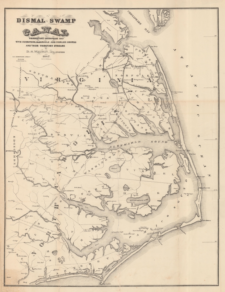
Dismal Swamp Canal Connecting Chesapeake Bay with Currituck, Albemarle and Pamlico Sounds and Their Tributary Streams.
1867 (dated) 22 x 17 in (55.88 x 43.18 cm) 1 : 595000
1867 (dated) 22 x 17 in (55.88 x 43.18 cm) 1 : 595000
Description
A fascinating 1867 David Smith Walton map of eastern Virginia and North Carolina illustrating the route of the Dismal Swamp Canal - America's oldest continuously operating canal. The map was issued as a part of the Dismal Swamp Canal Company's efforts to restore the canal after years of neglect during the American Civil War (1861 - 1865).
In 1826, recognizing unrealized potential, both Virginia and the Federal government acquired shares of the Dismal Swamp Canal Company, creating a unique partnership of Federal, State, and private interests. Improvements proceeded apace, and by 1828, the canal opened to commercial traffic and was capable of accommodating schooners and other small ships. The canal became a major artery and redefined economies along and around its route. It also had a profound ecological effect on the swamp itself.
By the 1850s, the DSCC began to suffer from increased competition, not only from ever-expanding railroad networks but also from the competing Albemarle and Chesapeake Canal, which opened in 1859. The matter became moot with the outbreak of the American Civil War (1861 - 1865).
In the early stage of the war, the canal was used extensively to transport Confederate troops and supplies, but by 1862, Union forces took control of the canal, which they maintained throughout the remainder of the war. They were not excellent stewards and by 1865, when the war ended and control was returned to the Dismal Swamp Canal Company, nature had done its job. The canal was left in poor condition, heavily silted, with encroaching vegetation. Moreover, Virginia, now bankrupt, was forced to sell its shares at a fraction of their pre-war value.
In 1866, the DSCC, now managed by E. C. Robinson, initiated reclamation efforts. They hired Confederate veteran and Civil Engineer Col. David Smith Walton to 'make an instrumental survey of the entire work with a view to its true condition future improvement'. This map is the result. He found the canal in an unusable state, but under his recommendations, stop-gap measures were employed and the canal gradually reopened for business.
Despite reopening, the DSCC remained in financial ruin. In 1878, the federal government sold its shares. There were attempts to reorganize the company in the 1880s, but these failed. Ultimately, in 1892, the Lake Drummond Canal and Water Company acquired the canal. They financed extensive renovations between 1896 and 1899, after which it opened for business, again becoming an important and successful trade artery. Today the Dismal Swamp Canal is owned by the federal government and remains an active waterway.
A Closer Look
Coverage embraces from the mouth of the Chesapeake Bay to Cape Lookout, and inland as far as Edgcombe County, thus embracing the Albemarle and Pamlico Sounds, their associated river estuaries, and the outer banks. The focus is naturally on transportation routes, particularly canals and railroads. The routes of both the Dismal Swamp Canal, the connecting Jericho Canal, and the competing Albemarle and Chesapeake Canal are bolded. Also of note are various railroads, including a proposed 'Air Line Rail Road connecting Edenton with Hintonsville' (and so the DSC). Existing North Carolina railroads depicted include the Atlantic and North Carolina Rail Road and Wilmington and Weldon Rail Road. Two grand hotels are noted in the Outer Banks: the Alexina Hotel and the Currituck Sea-Side Hotel, both long lost.The Dismal Swamp Canal
The Dismal Swamp Canal is the oldest continuously operating canal in the United States. Plans for the canal date to just after the American Revolutionary War (1775 - 1783) when luminaries George Washington, Thomas Jefferson, and Patrick Henry lobbied for it. The idea was for an inland waterway to connect the Chesapeake Bay with the Albemarle Sound, thus removing the need for deep draft oceangoing vessels to navigate around Cape Hatteras. The Dismal Swamp Canal Company was chartered and digging began in 1793 and completed in 1805. The work, done mostly by rented slaves, was described unfavorably as 'little more than a muddy ditch' and could only support flatboats.In 1826, recognizing unrealized potential, both Virginia and the Federal government acquired shares of the Dismal Swamp Canal Company, creating a unique partnership of Federal, State, and private interests. Improvements proceeded apace, and by 1828, the canal opened to commercial traffic and was capable of accommodating schooners and other small ships. The canal became a major artery and redefined economies along and around its route. It also had a profound ecological effect on the swamp itself.
By the 1850s, the DSCC began to suffer from increased competition, not only from ever-expanding railroad networks but also from the competing Albemarle and Chesapeake Canal, which opened in 1859. The matter became moot with the outbreak of the American Civil War (1861 - 1865).
In the early stage of the war, the canal was used extensively to transport Confederate troops and supplies, but by 1862, Union forces took control of the canal, which they maintained throughout the remainder of the war. They were not excellent stewards and by 1865, when the war ended and control was returned to the Dismal Swamp Canal Company, nature had done its job. The canal was left in poor condition, heavily silted, with encroaching vegetation. Moreover, Virginia, now bankrupt, was forced to sell its shares at a fraction of their pre-war value.
In 1866, the DSCC, now managed by E. C. Robinson, initiated reclamation efforts. They hired Confederate veteran and Civil Engineer Col. David Smith Walton to 'make an instrumental survey of the entire work with a view to its true condition future improvement'. This map is the result. He found the canal in an unusable state, but under his recommendations, stop-gap measures were employed and the canal gradually reopened for business.
Despite reopening, the DSCC remained in financial ruin. In 1878, the federal government sold its shares. There were attempts to reorganize the company in the 1880s, but these failed. Ultimately, in 1892, the Lake Drummond Canal and Water Company acquired the canal. They financed extensive renovations between 1896 and 1899, after which it opened for business, again becoming an important and successful trade artery. Today the Dismal Swamp Canal is owned by the federal government and remains an active waterway.
Publication History and Census
This map was compiled by David Smith Walton and printed by Hosford and Sons of New York, in 1867. It is at least in part derived from a very similar map, with similar coverage, drawn by John Lathrom, dated 1857, and titled 'Albemarle and Chesapeake Canal' (New York Public Library, b20646497). It appears to have been published twice. First, in a corporate report issued in 1867 by the Dismal Swamp Canal Company, and again in 1878 for the House of Representatives (45th Congress, 2nd Session, Ex. Doc. No. 19). We see about 7 examples in OCLC, from both issues. Scarce to the market.CartographerS
David Smith Walton (May 2, 1816 - May 9, 1889) was an American civil engineer active in the mid to late 19th century. Walton was born in Otsego County, New York. He worked as a civil engineer on the Erie Canal until 1853, when he relocated to Portsmouth, Virginia. He was commissioned as a major in 1856 to command volunteer militia organization in Norfolk County, the 1st Battalion, 3rd Regimental Virginia Volunteers. As a volunteer regiment, officers were elected, and Walton was twice elected, first as Lt. Colonel, then ad Colonel. He stepped down from this post in 1858 to resume engineering work. During American Civil War (1861 - 1865), he served the Confederate cause. He was assigned to construct a defensive battery along Hospital Point, Portsmouth. After the war, he was hired by the Dismal Swamp Canal Company to evaluation the condition of the canal and consult on improvements. More by this mapmaker...
Hosford and Sons (fl. c. 1851 - 1872), also operating as 'Hosford and Ketcham', was a stationer, lithographing, and printing concern based in New York City in the mid-late 19th century. They specialized in bank notes, stock certificates, business forms, and other official stationary. The firm consisted of Frederick J. Hosford (1811 - 1889) and Charles F. Ketcham (1831 - January 21, 1900). Later F. J. Hosford's sons, Henry Hosford (1839 - ????), and James Spencer Hosford (1837 - October 20, 1922), joined the firm. The partner firms operated out of 57 and 59 William Street. Ketcham pull out of the operation sometime around 1870, and started his own firm at 27-29 Nassau Street. The Hosford Brothers relocated to 56 Cedar Street, where they continued to operate as Hosford and Sons. In the 1880s, J. S. Hosford moved upstate to become a gentleman farmer. Learn More...
Condition
Average. Laid down on archival tissue to stabilize old fold splits and closed tears. Wear and soiling on old fold lines.
References
OCLC 29617311. University of North Carolina at Chapel Hill, #Cm912.02 1867w.