
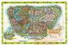
1964 Walt Disney Productions Pictorial Wall Map of Disneyland

This item has been sold.
Walt Disney's Magic Kingdom Disneyland, U.S.A. Anaheim, California.
The Happiest Place on Earth?
Choose a Collection:
This Item
Enquire
The Happiest Place on Earth?
This is a 1964 Walt Disney Productions pictorial wall map of Disneyland. Published nine years after the park opened, banners highlight different parts of the park, such as Fantasyland, Frontierland, Adventureland, and Tomorrowland. Smaller text identifies attractions, including the Mad Tea Party, the Enchanted Tiki Room, Fantasyland Autopia, and the Jungle Cruise. Future attractions are also identified, such as the Haunted Mansion and the Pirates of the Caribbean. The railroad and the monorail both grab attention. The whole is surrounded by a border of Disney characters: Mickey Mouse, Donald Duck, Minnie Mouse, Alice from Alice in Wonderland, Peter Pan, Dumbo, and Bambi.Publication History and Census
This map was published by Walt Disney Productions in 1964. We note four examples cataloged in OCLC: Ohio State University, Stanford University, the University of Florida, and the University of California Los Angeles.Condition
Good. Wear along original fold lines. Slight loss at a handful of fold intersections. Toning.
References
OCLC 772514929, 953572516.