1659 Blaeu Map of the Southern Islands of Denmark
LaalandFalster-blaeu-1659$450.00

Title
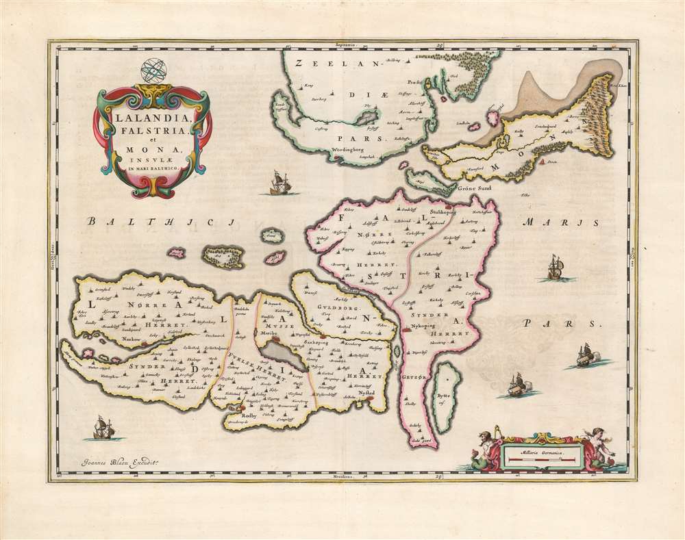
Lalandia, Falstria et Mona Insulae in Mari Balthico.
1659 (undated) 15.25 x 20.5 in (38.735 x 52.07 cm) 1 : 160000
1659 (undated) 15.25 x 20.5 in (38.735 x 52.07 cm) 1 : 160000
Description
This is Joan Blaeu's 1659 map of the islands of Laaland, Falster, and Møn, the southeastern part of Denmark. It is among the scarcest of Blaeu's maps, appearing in a sole edition of the Novuus Atlas and subsequently only in the Atlas Maior. The map is superbly engraved and colored, with a lovely cartouche and sailing ships: typical of the younger Blaeu's work at its creative peak.
The Competition's Map
On the other hand, Blaeu's map builds faithfully on competitor Jan Jansson's 1644 map of the Laaland and Falster, while broadening the map's scope to include Møn.Publication History and Census
This map was printed first in 1659 for inclusion in the Spanish edition of Novuus Atlas, and was included without change in subsequent editions of the Atlas Maior. Three examples of the complete Nuevo atlas o Teatro del mundo are cataloged in OCLC. Twelve listings of the separate map in various issues appear.Cartographer
Joan (Johannes) Blaeu (September 23, 1596 - December 21, 1673) was a Dutch cartographer active in the 17th century. Joan was the son of Willem Janszoon Blaeu, founder of the Blaeu firm. Like his father Willem, Johannes was born in Alkmaar, North Holland. He studied Law, attaining a doctorate, before moving to Amsterdam to join the family mapmaking business. In 1633, Willem arranged for Johannes to take over Hessel Gerritsz's position as the official chartmaker of the Dutch East India Company, although little is known of his work for that organization, which was by contract and oath secretive. What is known is his work supplying the fabulously wealthy VOC with charts was exceedingly profitable. Where other cartographers often fell into financial ruin, the Blaeu firm thrived. It was most likely those profits that allowed the firm to publish the Theatrum Orbis Terrarum, sive, Atlas Novus, their most significant and best-known publication. When Willem Blaeu died in 1638, Johannes, along with his brother Cornelius Blaeu (1616 - 1648) took over the management of the Blaeu firm. In 1662, Joan and Cornelius produced a vastly expanded and updated work, the Atlas Maior, whose handful of editions ranged from 9 to an astonishing 12 volumes. Under the brothers' capable management, the firm continued to prosper until the 1672 Great Amsterdam Fire destroyed their offices and most of their printing plates. Johannes Blaeu, witnessing the destruction of his life's work, died in despondence the following year. He is buried in the Dutch Reformist cemetery of Westerkerk. Johannes Blaeu was survived by his son, also Johannes but commonly called Joan II, who inherited the family's VOC contract, for whom he compiled maps until 1712. More by this mapmaker...
Source
Blaeu, J., Nuevo Atlas, (Amsterdam: Blaeu) 1659.
The classic Dutch atlas, whose publication ushered in the Dutch golden age of cartography. Willem Jansz Blaeu had been, since 1604, producing engraved maps for sale; these were separate issues (and all consequently extremely rare) until the publishing of Blaeu's Appendix in 1630 and 1631, which also included a number of maps purchased from the widow of Jodocus Hondius, (for example his famous iteration of John Smith's map of Virginia.) In 1634, he announced his intention to produce a new world atlas in two volumes, entitled Theatrum Orbis Terrarum, sive Atlas Novus (Théâtre du Monde ou Nouvel Atlas) (in an effort to invoke the successful work of the same title produced by Ortelius the previous century, while reinforcing the notion of it being a new work.) This work was published first in German in 1634, followed by Latin, Dutch and French editions in 1635. Blaeu's maps have always been noted for the quality of their paper, engraving and fine coloring, and this was the intent from the very start. The 1634 announcement of the upcoming work described it: 'All editions on very fine paper, completely renewed with newly engraved copperplates and new, comprehensive descriptions.' (van der Krogt, p,43) Many of the most beautiful and desirable maps available to the modern collector were printed and bound in Blaeu's atlases. Willem's son, Joan, would go on to add further volumes to the Atlas Novus, concurrently printing new editions of the first two volumes with additional maps, in effect making these new editions an entirely new book. Under Joan there would be nine Latin editions, twelve French, at least seven Dutch, and two German. This exceedingly successful work would be the mainstay of the Blaeu firm until 1661, at which point the work was supplanted by Joan Blaeu's masterwork Atlas Maior in 1662.
Condition
Fine condition, an early strike with superb original color.
References
OCLC 828268341. Rumsey 10017.040 (1665). Van der Krogt, P. C. J., Koeman's Atlantes Neerlandici, V. 1, 1540:2:641.