This item has been sold, but you can get on the Waitlist to be notified if another example becomes available, or purchase a digital scan.
1940 Clason Map or Plan of Chicago, Illinois (Magnificent Mile, the Loop and Downtown Chicago)
DowntownChicago-clason-1940$125.00

Title
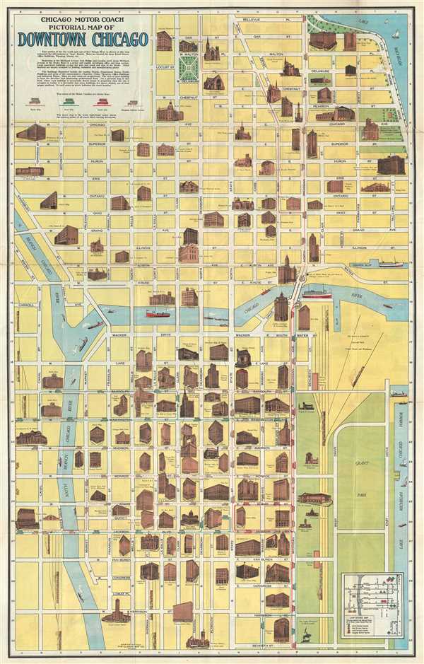
Chicago Motor Coach Pictorial Map of Downtown Chicago.
1940 (undated) 33.5 x 21.5 in (85.09 x 54.61 cm) 1 : 4000
1940 (undated) 33.5 x 21.5 in (85.09 x 54.61 cm) 1 : 4000
Description
This is an attractive c.1940 map or plan of Chicago, Illinois issued by The Clason Map Co., Illinois. It covers from Harrison Street north to Bellevue Place and west as far as Canal St., depicting downtown Chicago, including the Magnificent Mile and the Chicago Loop or old business districts.
Important buildings, representing leading hotels, department stores, public buildings, churches, clubs, theaters, office buildings and industrial plants, are shown in profile. Individual streets are named, with parks, coach routes and railroads identified. Beautiful illustrations of ships and sailboats are included in the river and lake. An inset in the lower right quadrant notes the starting points of all coach lines running downtown. An explanation below the title notes the significance of downtown Chicago and the areas depicted here.
This map was copyrighted and issued by the Clason Map Company, Chicago.
Cartographer
George Samuel Clason (November 7, 1874 - 1957) was born in the city of Louisiana, Missouri in 1874. As a young man, Clason studied at the University of Nebraska before joining the United States Army in 1898 to fight in the Spanish American War. After the war, he moved to Denver, Colorado where in 1905 he founded the Clason Map Company, thus starting his lucrative publishing career. Clason initially focused on mining and mineral maps - capitalizing on the Colorado and Nevada mining industry, but quickly transitioned to railroad maps, city maps, and by the 1920s, road maps. As the company expanded, Clason opened a secondary office in Chicago, Illinois - then a rising map publishing center and railroad hub. At least one other satellite office was opened in Los Angeles. Among his many achievements, Clason is credited with producing the first modern road atlas of the United States. In the late 1920s, Clason also published a series of get-rich-quick pamphlets in the form of parables. The most famous of these is The Richest Man in Babylon. This tells the story of Arkad, a citizen of Babylon famed for his great wealth and generosity who shares his wit and wisdom with his fellow Babylonians. In 1949, Clason moved to Napa, California to retire and found a social club for retired gentlemen. More by this mapmaker...
Condition
Very good. Minor wear along original fold lines. Minor loss near top right, over Delaware Pl. and Shore Drive. Professionally flattened and backed with archival tissue.
References
Rumsey 8739.002.