This item has been sold, but you can get on the Waitlist to be notified if another example becomes available, or purchase a digital scan.
1945 Barcus Pictorial City Map or Plan of Detroit, Michigan
DowntownDetroit-barcus-1945$112.50

Title
Pictorial Map of Downtown Detroit.
1945 (dated) 16.75 x 21.25 in (42.545 x 53.975 cm)
1945 (dated) 16.75 x 21.25 in (42.545 x 53.975 cm)
Description
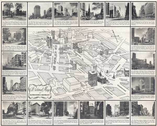
This is a 1945 Frank Barcus pictorial city map or plan of Detroit, Michigan. The map depicts downtown Detroit from Cass Street to Randolph Street and from Adams Avenue to Fort Street. Buildings in downtown are rendered in profile, some of them in more detail than others. R. H. Fyfe and Co., the Statler Hotel, the Greyhound Bus Depot, Wright, Kay, and Company, the Commonwealth Bank, and City Hall are among the buildings illustrated in detail. Other buildings around downtown Detroit are labeled, including the Detroit Free Press building, the YMCA, the Federal Building and Post Office, and Eaton Tower. Grand Circus Park is illustrated in detail, along with the trees along the median of Washington Boulevard. The map is framed by eighteen numerically identified photographs of downtown Detroit. The numbers correspond to locations on the map, which are marked by numbers in small circles. A caption, below each of the photographs, details what buildings can be seen in each photo, and in certain cases, gives a tidbit of history about the building or the company which occupies it. By 1945, the auto industry was booming and Detroit emerged as one of the largest metropolitan areas in the United States.
This map was produced by Frank Barcus in 1945.
This map was produced by Frank Barcus in 1945.
Condition
Very good. Slight wear along original fold lines. Verso repairs of fold separations. Text on verso.
References
OCLC 864852466.