This item has been sold, but you can get on the Waitlist to be notified if another example becomes available, or purchase a digital scan.
1705 Homann Map of Milan and Environs, Lombardy, Piedmont, Switzerland
DucatusMediolanensis-homann-1705$200.00

Title
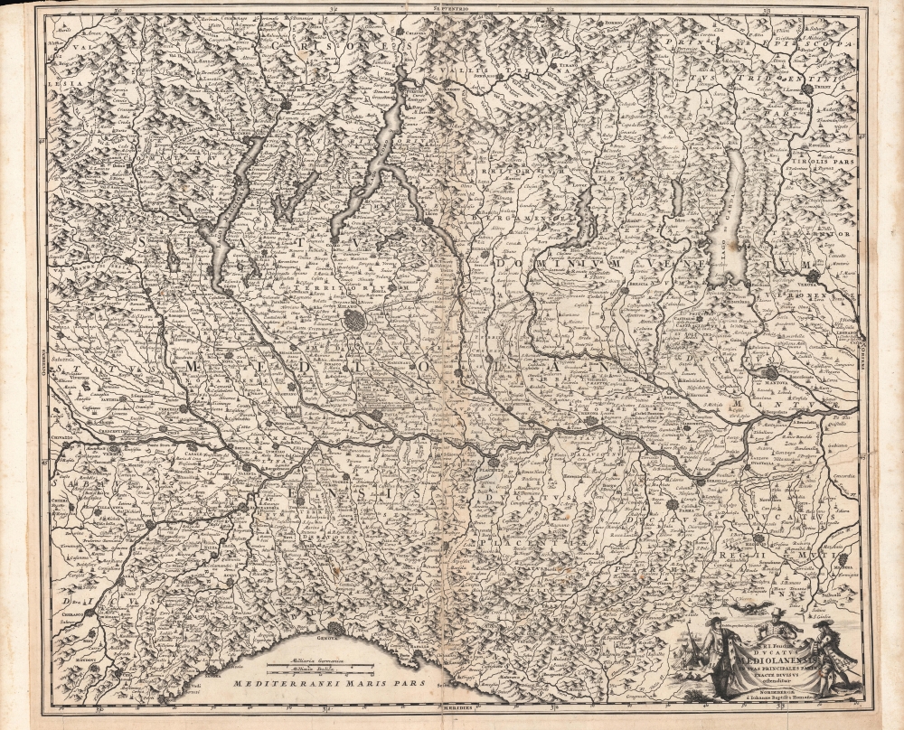
S.R.I. Feudum Ducatus Mediolanensis In Suas Principales Partes Exacte Divisus.
1705 (undated) 18.5 x 22.25 in (46.99 x 56.515 cm) 1 : 520000
1705 (undated) 18.5 x 22.25 in (46.99 x 56.515 cm) 1 : 520000
Description
A scarce, early map by Johann Baptist Homann, published c. 1705, depicting a wide region around Milan, including Lombardy, Piedmont, Trentino-Alto Adige, and much of Switzerland. It was produced during the War of the Spanish Succession (1700 - 1715), when northern Italy was one of several battlefields contested by rival Habsburg and Bourbon forces.
The recent fighting is mentioned, with a 'French defeat' outside Chiari (near center) on September 1, 1701, noted. The battle was a definitive victory for the Austrian Habsburgs over a larger French force and resulted in the immediate support of England and the Dutch Republic for the Holy Roman Emperor's claim to northern Italy. A later battle at Capri, far to the right, is also recorded. Moreover, the ongoing conflict is referenced by the martial figures surrounding the title cartouche, accompanied by the phrase 'render to Caesar the things that are Caesar's,' reflecting the Habsburg attitude towards northern Italy. Homann also marks the site of the Battle of Pavia in 1525, the decisive battle of the Italian War of 1521 - 1526, an earlier resounding Habsburg victory over invading French forces, which included the capture of the French king, Francis I.
A Closer Look
The regions of Lombardy and Piedmont, along with portions of Trentino-Alto Adige and Switzerland, are displayed in remarkable detail. Towns and cities (including Milan, Genoa, Parma, and Mantua), rivers, lakes (including Lago di Como and other grand lakes along the Italian-Swiss border), mountains, and territorial divisions are illustrated throughout. Scales of both German and Italian miles are provided.Historical Context
The abbreviation S.R.I. in the title refers to 'Sacri Romani Imperii,' a reminder that most of these lands were at least nominally ruled by the Holy Roman Emperor, which in the early modern period was always a Habsburg. However, at the start of the 18th century, just before the map was published, the Habsburg succession and Europe as a whole were thrown into upheaval by the War of the Spanish Succession (1700 - 1715). In 1706, Austrian forces defeated French troops backing a Bourbon claim to the Spanish throne at Turin (just beyond the scope of this map to the west), securing Austrian rule over northern Italy until the mid-19th century, with an interruption at the turn of the 19th century thanks to Napoleon.The recent fighting is mentioned, with a 'French defeat' outside Chiari (near center) on September 1, 1701, noted. The battle was a definitive victory for the Austrian Habsburgs over a larger French force and resulted in the immediate support of England and the Dutch Republic for the Holy Roman Emperor's claim to northern Italy. A later battle at Capri, far to the right, is also recorded. Moreover, the ongoing conflict is referenced by the martial figures surrounding the title cartouche, accompanied by the phrase 'render to Caesar the things that are Caesar's,' reflecting the Habsburg attitude towards northern Italy. Homann also marks the site of the Battle of Pavia in 1525, the decisive battle of the Italian War of 1521 - 1526, an earlier resounding Habsburg victory over invading French forces, which included the capture of the French king, Francis I.
Publication History and Census
This map was produced in the early 18th century by Johann Baptist Homann, before he received the title of Imperial Geographer, and is generally cataloged as 'between 1702 and 1707.' It is listed three times in the OCLC and is present at four institutions: the Universitäts- und Landesbibliothek Darmstadt, the Universitätsbibliothek Eichstätt-Ingolstadt, the Staats- und Stadtbibliothek Augsburg, and the Bayerische Staatsbibliothek. Though not noted in the OCLC, the map is also held by the Uniwersytet Wrocławski. It has no known history on the market. This map's plate was very likely the basis for Homann's later map of the same region 'Ducatus Mediolani una cum confinÿs accurata tabula,' as well as Matthäus Seutter's 'Ducatus Mediolanensis cum adjuacentibus Principat'.Cartographer
Johann Baptist Homann (March 20, 1664 - July 1, 1724) was the most prominent and prolific map publisher of the 18th century. Homann was born in Oberkammlach, a small town near Kammlach, Bavaria, Germany. As a young man, Homann studied in a Jesuit school and nursed ambitions of becoming a Dominican priest. Nonetheless, he converted to Protestantism in 1687, when he was 23. It is not clear where he mastered engraving, but we believe it may have been in Amsterdam. Homann's earliest work we have identified is about 1689, and already exhibits a high degree of mastery. Around 1691, Homann moved to Nuremberg and registered as a notary. By this time, he was already making maps, and very good ones at that. He produced a map of the environs of Nürnberg in 1691/92, which suggests he was already a master engraver. Around 1693, Homann briefly relocated to Vienna, where he lived and studied printing and copper plate engraving until 1695. Until 1702, he worked in Nuremberg in the map trade under Jacob von Sandrart (1630 - 1708) and then David Funck (1642 - 1709). Afterward, he returned to Nuremberg, where, in 1702, he founded the commercial publishing firm that would bear his name. In the next five years, Homann produced hundreds of maps and developed a distinctive style characterized by heavy, detailed engraving, elaborate allegorical cartouche work, and vivid hand color. Due to the lower cost of printing in Germany, the Homann firm could undercut the dominant French and Dutch publishing houses while matching their diversity and quality. Despite copious output, Homann did not release his first major atlas until the 33-map Neuer Atlas of 1707, followed by a 60-map edition of 1710. By 1715, Homann's rising star caught the attention of the Holy Roman Emperor Charles VI, who appointed him Imperial Cartographer. In the same year, he was also appointed a member of the Royal Academy of Sciences in Berlin. Homann's prestigious title came with several significant advantages, including access to the most up-to-date cartographic information as well as the 'Privilege'. The Privilege was a type of early copyright offered to very few by the Holy Roman Emperor. Though less sophisticated than modern copyright legislation, the Privilege offered limited protection for several years. Most all J. B. Homann maps printed between 1715 and 1730 bear the inscription 'Cum Priviligio' or some variation. Following Homann's death in 1724, the firm's map plates and management passed to his son, Johann Christoph Homann (1703 - 1730). J. C. Homann, perhaps realizing that he would not long survive his father, stipulated in his will that the company would be inherited by his two head managers, Johann Georg Ebersberger (1695 - 1760) and Johann Michael Franz (1700 - 1761), and that it would publish only under the name 'Homann Heirs'. This designation, in various forms (Homannsche Heirs, Heritiers de Homann, Lat Homannianos Herod, Homannschen Erben, etc.) appears on maps from about 1731 onwards. The firm continued to publish maps in ever-diminishing quantities until the death of its last owner, Christoph Franz Fembo (1781 - 1848). More by this mapmaker...
Condition
Average. Wear and discoloration along centerfold. Sporadic if minor discoloration and soiling. Repaired marginal tears, including one intruding into image at right. Marginal loss at top-left.
References
OCLC 633676387, 159838790, 1077703138.