1854 Maury Chart of East African Coast, Madagascar
EastAfricaChart-maury-1854$1,500.00


Title
Maury's Wind and Current Chart Series A, Indian Ocean No. 4.
1854 (dated) 35 x 24 in (88.9 x 60.96 cm) 1 : 5850000
1854 (dated) 35 x 24 in (88.9 x 60.96 cm) 1 : 5850000
Description
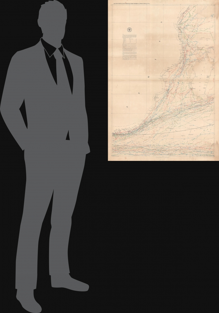
A colorful and remarkably detailed 1854 nautical map or chart of the eastern coast of Africa, from Kenya to South Africa. It was produced by Matthew Fontaine Maury, the greatest American hydrographer of his time, and like all of his wind and current charts is a marvel of infographic mapping.
Coastal hazards, degrees of magnetic variation, shoals (including those considered 'doubtful'), and even the temperature of waters are also indicated, as explained at left. Distinctive colorful lines denote the seasons in which vessels traveled. A thick black line tracks distances to Java Head (Tanjung Layar), a major navigational landmark at the western end of Java, confirming that most ships plying these waters were destined for or originating from the East Indies and beyond, most likely China.
A Closer Look
Characteristic of Maury's charts, exhaustive efforts are made to record the nature and intensity of winds and currents encountered by American and other nations' vessels that passed through these waters in the months before the chart's publication. Ships' routes fall into one of two categories: those skirting past Madagascar straight on to the Cape of Good Hope and those which sailed between Madagascar and the East African coast, in some cases in order to stop at ports, especially Zanzibar.Coastal hazards, degrees of magnetic variation, shoals (including those considered 'doubtful'), and even the temperature of waters are also indicated, as explained at left. Distinctive colorful lines denote the seasons in which vessels traveled. A thick black line tracks distances to Java Head (Tanjung Layar), a major navigational landmark at the western end of Java, confirming that most ships plying these waters were destined for or originating from the East Indies and beyond, most likely China.
Maury on the Wind and Current Chart Series
This chart was part of Maury's influential Wind and Current Chart Series. Maury explained the series in the introduction to the 1855 edition of his book The Physical Geography of the Sea,The primary object of the Wind and Current Charts, out of which has grown the Treatise on the Physical Geography of the Sea, was to collect the experience of every navigator as to the winds and currents of the ocean, to discuss his observations upon them, and then to present the world with the results on charts for the improvement of navigation.
Accordingly, when this object was made known, an appeal was addressed to the mariners, there was a flight up into the garrets, and a ransacking of time-honored sea-chests in all the maritime communities of the country for old log-books and journals.
It was supposed that the records therein contained as to the wind and weather, the sea and its currents, would afford information requisite for such an undertaking.
By putting down on a chart the tracks of many vessels on the same voyage but at different times, in different years, during all seasons, and by projecting along each track the winds and currents daily encountered, it was plain that the navigator hereafter, by consulting this chart, would have for a guide the results of the combined experience of all those whose tracks were thus pointed out.
Creating the Charts
After Maury became commander of the Depot of Charts and Instruments in July 1842, he was able to access the old logs of 'every voyage made by a commissioned ship in the Navy' which provided him with the necessary data to create his first charts. Not long after, Maury designed a data log and presented it to the Secretary of the Navy, who required all naval vessels to maintain these logs during every voyage. Since Maury's charts necessitated more data, he designed a much simpler chart than the one used by the Navy for use by merchantmen and convinced them to participate by offering free copies of his charts to any captain that provided data. Maury's influence, and that of the U.S. Naval Observatory and Hydrographical Office, became worldwide following the 1853 international conference on the ocean environment, where the major seafaring nations of the world adopted a log designed by Maury and 'agreed to cooperate in the collection of information for the betterment of navigation'. Maury, nonetheless, fell out of favor with Alexander Dallas Bache, head of the U.S. Coast Survey, in 1861 due to his Confederate sympathies. He left Washington for Richmond, and his work was subsequently shunned and mostly forgotten in both navel and academic circles. Today his charts are rare and highly desirable.Publication History and Census
This map was drawn by naval officer R. H. Wyman and produced by Matthew Fontaine Maury in February 1854. It carries the stamp of the US Hydrographical Office above the explanatory notes. This chart is independently cataloged by two institutions, the Library of Virginia and the American Geographical Society Library at the University of Wisconsin-Milwaukee, and is cataloged as part of the entire Indian Ocean series by the Library of Congress, Yale University, and Brown University.CartographerS
Matthew Fontaine Maury (January 14, 1806 - February 1, 1873) was an American astronomer, historian, oceanographer, meteorologist, cartographer, author, geologist, educator, and United States Navy officer. Maury was born in Spotsylvania County, Virginia, near Fredericksburg. He was nicknamed "Pathfinder of the Seas" and "Father of Modern Oceanography and Naval Meteorology" and later, "Scientist of the Seas," due to the publication of his extensive works in his books, especially Physical Geography of the Sea (1855), the first extensive and comprehensive book on oceanography to be published. Maury made many important new contributions to charting winds and ocean currents, including ocean lanes for passing ships at sea. In 1825 at age nineteen, Maury joined the United States Navy as a midshipman on board the frigate USS Brandywine. Almost immediately he began to study the seas and record methods of navigation. When a leg injury left him unfit for sea duty, Maury devoted his time to the study of navigation, meteorology, winds, and currents. His hard work on and love of plotting the oceans paid off when he became Superintendent of the U.S. Naval Observatory and head of the Depot of Charts and Instruments. There, Maury studied thousands of ships' logs and charts. He published the Wind and Current Chart of the North Atlantic, which showed sailors how to use the ocean's currents and winds to their advantage and drastically reduced the length of ocean voyages. Maury's uniform system of recording oceanographic data was adopted by navies and merchant marines around the world and was used to develop charts for all the major trade routes. Maury's work on ocean currents led him to advocate his theory of the Northwest Passage, as well as the hypothesis that an area in the ocean near the North Pole is occasionally free of ice. The reasoning behind this was sound: Marked harpoons found in captured whales in the Atlantic had been shot by ships in the Pacific and vice versa, and this occurred with a frequency that would have been impossible had the whales traveled around Cape Horn. With the outbreak of the Civil War, Maury, a Virginian, resigned his commission as a U.S. Navy commander and joined the Confederacy. He spent the war in the South, as well as abroad in Great Britain, acquiring ships for the Confederacy. As a result of his Confederate sympathies, Maury's work was de-emphasized in the Reconstruction era, particularly by Alexander D. Bache, head of the U.S. Coast Survey. Following the war, Maury accepted a teaching position at the Virginia Military Institute in Lexington, Virginia. He died at his home in Lexington in 1873 after completing an exhausting national lecture tour. More by this mapmaker...
United States Hydrographic Office (1866 - 1962) was a brach of he U.S. Navy that prepared and published maps, charts, and nautical books to aid in navigation. Before the establishment of the Hydrographic Office in 1866, U.S. navigators were almost entirely dependent on British charts. There had been a few private enterprises that had prepared and published charts, but none had been able to do so profitably. The Office was established 'for the improvement of the means of navigating safely the vessels of the Navy and of the mercantile marine, by providing, under the authority of the Secretary of the Navy, accurate and cheap nautical charts, sailing directions, navigators, and manuals of instructions for the use of all vessels of the United States, and for the benefit and use of navigators generally.' This way the Navy Department could furnish navy and merchant ships with charts illustrating the results of surveys and explorations undertaken by naval officers. The charts were priced to cover the cost of paper and printing alone, not preparation. Its main objective was to survey foreign coasts, as the Coast and Geodetic Surveys were responsible for surveying domestic waters. The Hydrographic Office was transferred from the Department of the Navy to the Department of Defense in 1949 and was replaced by the Naval Oceanographic Office in 1962. Learn More...
Condition
Very good. Toning along centerfold. Dampstaining at right, most noticeable at bottom-right corner. Creasing at top and bottom margin.
References
OCLC 213416173, 65215698. Pinsel, M.I. 'The Wind and Current Chart Series Produced by Matthew Fontaine Maury', Navigation: Journal of the Institute of Navigation, Vol. 28, No. 2, Summer 1981, pp. 123 - 137.