This item has been sold, but you can get on the Waitlist to be notified if another example becomes available, or purchase a digital scan.
1846 Meyer Map of East Asia, China, Korea, Japan
EastAsia-meyer-1846$87.50

Title
Chinesische Reich mit seinen Schutzstaaten nebst dem Japanischen Inselreiche.
1846 (dated) 11.5 x 14 in (29.21 x 35.56 cm) 1 : 19200000
1846 (dated) 11.5 x 14 in (29.21 x 35.56 cm) 1 : 19200000
Description
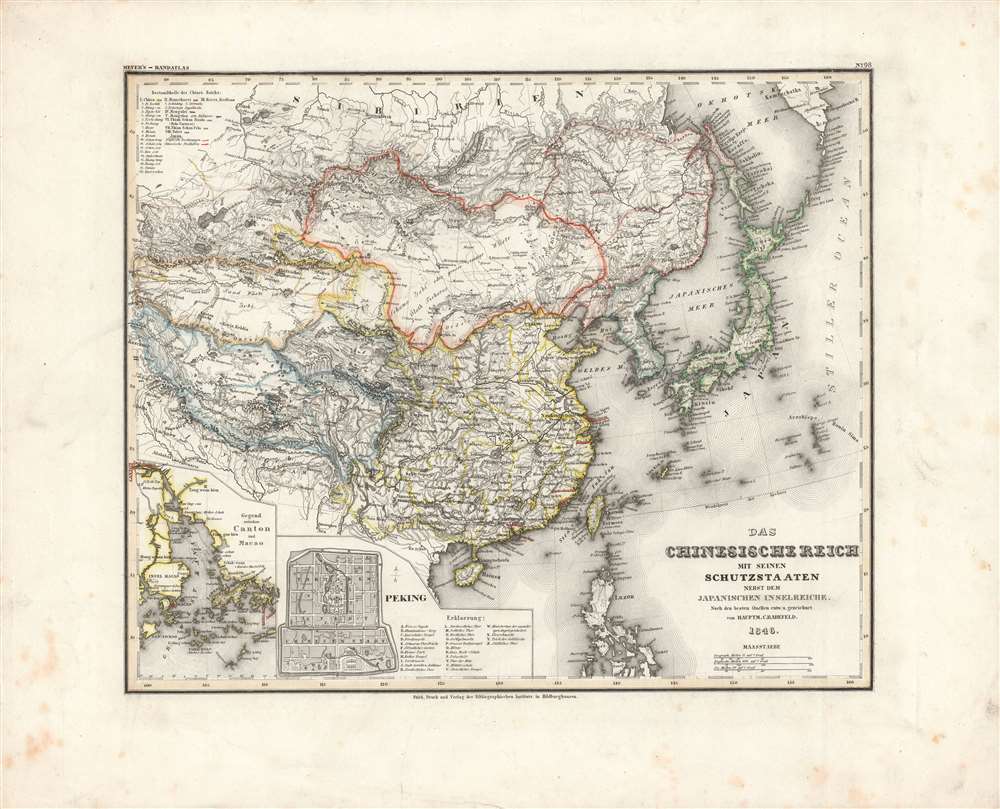
Here is Carl Radefeld's attractive 1846 map of East Asia, produced for Meyer's Grosser Hand-Atlas. It depicts the region in the wake of the Opium War (1839-1842), when the momentous changes initiated by that conflict had just begun and were not yet fully understood.
At top is Siberia and the outposts of the Russian empire there (Omsk, Irkutsk, etc.). The border between the Qing and Russian empires follows the Treaty of Nerchinsk (1689), prior to several treaties in the 1850s-1860s, when a weakened Qing Dynasty was forced to surrender swathes of territory in Manchuria to Russia.
Recently-created treaty ports are underlined in red, with the exception of Shanghai, which had not yet attained anything like its later size and prominence. Just north of Shanghai, Zhoushan (Tschusan) is underlined, as it had been captured by the British during the Opium War and held by them until 1846 as a ransom to ensure that the Qing implemented the Treaty of Nanjing, which ended the conflict. Prior to the Opium War, Zhoushan had been one of the main sites of China's foreign trade and maritime interactions, but in the decades following the Treaty of Nanjing it was quickly eclipsed by Shanghai.
At bottom-left are two insets, one of the Pearl River Delta, including Hong Kong, Macao, and Canton (Guangzhou), and the other of Beijing. The 'English Factory' at Canton, along with the recently-acquired colony of Hong Kong and the Portuguese colony at Macao are marked out in red. Beijing is divided into three sections, the imperial palace or 'Forbidden City' at center, surrounded by the 'Tartar' or Inner City of high-level Qing officials and servants of the imperial household, and the Chinese or Outer City of lower officials and other residents of the city.
Tokugawa Japan and Joseon Korea are also depicted, though Western knowledge about both countries was quite limited at the time. Japan would soon follow China in being on the receiving end of gunboat diplomacy, in their case at the hands of the Americans, while Korea managed to fend off multiple foreign military expeditions until definitively being 'forced open' by Japan in the 1870s.
The British victory in that conflict was a shock to the Qing system and the existing order in East Asia. Combined with pre-existing problems such as overpopulation and a deeply understaffed bureaucracy, the economic, social, and political forces unleashed following the Opium War set off drastic upheavals in China. The 1850-1860s saw the Qing fending off multiple internal uprisings simultaneously, the largest being the Taiping Rebellion, which managed to capture much of southern China before stalling out and gradually being pushed back.
A Closer Look
Significantly, Radefeld clearly distinguishes the various portions of the Qing empire, from 'China proper' (outlined in yellow), to Manchuria, Mongolia, Kokonor (or Qinghai in Chinese), Tibet, and the Tianshan nanlu ('Southern March') and Tianshan beilu ('Northern March'), that is, roughly, the southern and northern portions of what later became Xinjiang, which the Qing had conquered in the 1750s. Although the vast majority of the population under Qing rule lived in China proper and the emperors' rule in other parts of the empire was fairly loose, in terms of territory the areas outside of China proper constituted a majority of the realm.At top is Siberia and the outposts of the Russian empire there (Omsk, Irkutsk, etc.). The border between the Qing and Russian empires follows the Treaty of Nerchinsk (1689), prior to several treaties in the 1850s-1860s, when a weakened Qing Dynasty was forced to surrender swathes of territory in Manchuria to Russia.
Recently-created treaty ports are underlined in red, with the exception of Shanghai, which had not yet attained anything like its later size and prominence. Just north of Shanghai, Zhoushan (Tschusan) is underlined, as it had been captured by the British during the Opium War and held by them until 1846 as a ransom to ensure that the Qing implemented the Treaty of Nanjing, which ended the conflict. Prior to the Opium War, Zhoushan had been one of the main sites of China's foreign trade and maritime interactions, but in the decades following the Treaty of Nanjing it was quickly eclipsed by Shanghai.
At bottom-left are two insets, one of the Pearl River Delta, including Hong Kong, Macao, and Canton (Guangzhou), and the other of Beijing. The 'English Factory' at Canton, along with the recently-acquired colony of Hong Kong and the Portuguese colony at Macao are marked out in red. Beijing is divided into three sections, the imperial palace or 'Forbidden City' at center, surrounded by the 'Tartar' or Inner City of high-level Qing officials and servants of the imperial household, and the Chinese or Outer City of lower officials and other residents of the city.
Tokugawa Japan and Joseon Korea are also depicted, though Western knowledge about both countries was quite limited at the time. Japan would soon follow China in being on the receiving end of gunboat diplomacy, in their case at the hands of the Americans, while Korea managed to fend off multiple foreign military expeditions until definitively being 'forced open' by Japan in the 1870s.
Shifting Balance of Power
This map was published at a time when the regional and global balance of power was shifting dramatically. The Qing Dynasty, which had built a massive empire with a well-functioning bureaucracy in the 17th and 18th centuries, was now facing multiple severe challenges due to both internal and external pressures. After decades of tension over the illegal opium trade in and around Canton, which had been driven by the British, the Qing retaliated by sending the incorruptible official Lin Zexu to crack down on smuggling. Lin proceeded to seize and then burn the stores of the British opium traders in Canton, wiping out their annual profits. In response, the traders (i.e., drug smugglers) used their influence in Parliament to gain backing for a punitive military expedition against China, setting off the first Opium War in 1839.The British victory in that conflict was a shock to the Qing system and the existing order in East Asia. Combined with pre-existing problems such as overpopulation and a deeply understaffed bureaucracy, the economic, social, and political forces unleashed following the Opium War set off drastic upheavals in China. The 1850-1860s saw the Qing fending off multiple internal uprisings simultaneously, the largest being the Taiping Rebellion, which managed to capture much of southern China before stalling out and gradually being pushed back.
Publication History and Census
This map was engraved, printed, and published by Carl Radefeld of the Bibliographisches Institut in Hildburghausen, a company founded by Joseph Meyer. It appeared as map No. 98 in Meyer's Grosser Hand-Atlas, a landmark work of mid-19th century German cartography. Although the map itself is dated as 1846, the Grosser Hand-Atlas was not published and distributed until 1860. Despite an identical title and similar format, it differs from the 1839 map in Steiler's Hand-Atlas as well as an 1856 map attributed to Joseph Grässl and Wilhelm Issleib, also published by Meyer in Hildburghausen. This map is not known to be cataloged among the holdings of any institution, while Meyer's Grosser Hand-Atlas is held by perhaps a dozen institutions in North America and Europe.CartographerS
Joseph Meyer (May 9, 1796 - June 27, 1856) was a German industrialist, merchant, and publisher, active in Germany in the early to mid 19th century. He is best known for publishing the encyclopedia Meyers Conversation-Lexicon. Born in Gotha, Germany, Meyer was educated as a merchant in Frankfurt am Main. He moved to London in 1816, but returned to Germany in 1820 after his stock speculations and business adventures fell through. Once back in Germany, he began by investing in the textile trade (1820 - 24). Meyer began creating business plans concerning how to start railways soon after the first steam-hauled railway began operation in December 1835. He founded the Deutsche Eisenbahnschienen-Compangie auf Actien (German Railway Rail joint stock company) in 1845. Meyer also found great success as a publisher, utilizing the system of serial subscriptions to publications, a new idea for the time. He founded a company, Bibliographisches Institut in Gotha in 1825, which published several versions of the Bible, works of classical literature, atlases, the world in pictures on steel engravings, and an encyclopedia. He moved the Institut from Gotha to Hildburghausen in 1828. He published several atlases, including Meyer's Groẞer Hand-Atlas (1843 - 1860). In 1848, he supported the Springtime of the Peoples Revolutions that took place throughout Germany and much of Europe. When the revolutions failed in 1849, Meyer was briefly imprisoned for his support of revolutionary activities. The revolutions also began to take a toll on Meyer's business interests, and when he died, in 1856, the Bibliographisches Institut was struggling financially. His son, Herrmann Julius Meyer, took over the firm, spearheading a rapid recovery. This, and other businesses prospered under Herrmann Julius (April 4, 1826 - March 12, 1909) and when he died in 1909, he led the richest family in Saxony, with more total wealth than the King of Saxony More by this mapmaker...
Carl Christian Franz Radefeld (1788 - 1874) was a German lawyer and cartographer. Radefeld was born in Jena, Germany, where he studied law and theology and began working as a lawyer in 1811. He became interested in cartography in the 1840s when he became involved with map and atlas publisher Joseph Meyer (1796 - 1856). From 1846, he contributed maps to Meyer's Groẞer Hand-Atlas (1843 - 1860). Learn More...
Source
Meyer, J., Grosser Hand-Atlas uber alle Theile der Erde in 170 Karten, (Hildburghausen: Verlag des Bibliographischen Instituts) 1860.
Condition
Very good. Light foxing and ink smudges in margins.
References
Rumsey 4807.114.