This item has been sold, but you can get on the Waitlist to be notified if another example becomes available, or purchase a digital scan.
1752 D'Anville Map of Southeast Asia, the East Indies, China, Korea and Japan
EastAsiaSoutheastAsia-anville-1752-2$1,250.00


Title
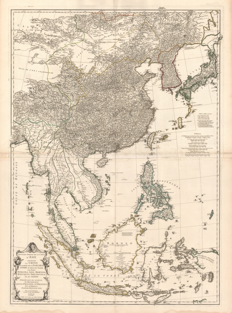
Seconde partie de la Carte d'Asie contenant La Chine et Partie de la Tartarie, L'Inde au de la du Gange, les Isles Sumatra, Java, Borneo, Moluques, Philippines, et du Japon.
1752 (dated) 39 x 28 in (99.06 x 71.12 cm) 1 : 7150000
1752 (dated) 39 x 28 in (99.06 x 71.12 cm) 1 : 7150000
Description
A beautiful example of French cartographer J. B. B. d'Anville's 1752 map of the East Indies, China, Korea, and Japan. This influential map redefined European perceptions of East Asia and remained the dominant cartographic assessment of the region until the early 19th century.
Here D'Anville successfully draws on a variety of sources to redefine the map of East Asia. For China, he relies on his own 1732 reconsideration of Chinese cartography based upon the remapping of the empire undertaken in 1708 by order of the Kangxi Emperor. In Japan, an area forbidden to Europeans, he draws on several sources, including Dutch maps and the Japanese maps of Hayashi Shihei (林 子平), among others. The mapping of the Philippines follows the 1734 Murillo Velarde map. For Java, D'Anville draws from Dutch sources. Southeast Asia and the remainder of the East Indies are notable for being overwhelmingly blank in contrast - reflecting the lack of European penetration into those regions.
A Closer Look
This impressive map covers from Mongolia and Hokkaido south as far as Timor and Java, including all of China, Japan, Taiwan (Formosa), Korea, the Philippines, Vietnam (Tonquin and Chochine), Laos, Cambodia, Thailand (Siam), Pegu (Burma, Myanmar), Tibet, Malay, Singapore, Sumatra, and Borneo, as well as most of modern-day Indonesia.Here D'Anville successfully draws on a variety of sources to redefine the map of East Asia. For China, he relies on his own 1732 reconsideration of Chinese cartography based upon the remapping of the empire undertaken in 1708 by order of the Kangxi Emperor. In Japan, an area forbidden to Europeans, he draws on several sources, including Dutch maps and the Japanese maps of Hayashi Shihei (林 子平), among others. The mapping of the Philippines follows the 1734 Murillo Velarde map. For Java, D'Anville draws from Dutch sources. Southeast Asia and the remainder of the East Indies are notable for being overwhelmingly blank in contrast - reflecting the lack of European penetration into those regions.
Errors, but still the Best
This map is deceptively sophisticated and dense, so much so that one is immediately inclined to praise its depth without considering its cartographic shortcomings. D'Anville presents a highly impressive map of a region then only tenuously understood by European geographers. Korea (Corée) is notably square at the base. Hokkaido (Yesso) is attached to the Japanese mainland as well as grossly malformed. Okinawa (Lekeyo) is so massively oversized that it nearly eclipses Taiwan - a clear indication that D'Anville is drawing from Japanese manuscript sources, such as the Hayashi Shihei maps, that typically mapped the island as such. The map's density rapidly diminishes as once moves south out of China into the lesser-known kingdoms of Southeast Asia and the East India Islands. While the major river systems are mapped with some accuracy, particularly in Pegu (Burma), Siam (Thailand), Laos, and Cambodia, the remainder of the region is vague at best. The interiors, with the exception of Java and the Philippines, both of which had been aggressively mapped by the Dutch and Spanish, respectively, are generally empty and vague. A wall separates the northern (Tonkin) and southern (Cochinchine) Vietnamese kingdoms. The Straits of Singapore (Sin Capura) are noted and the island of Singapore is present, if unlabeled.Publication History and Census
D'Anville prepared this map in 1752. Like most D'Anville maps, it was an independent issue and included in various made-to-order atlases on a case-by-case basis. It was engraved for D'Anville by Guillaume Delahaye. Well represented institutionally but scarce on the market.CartographerS
Jean Baptiste Bourguignon d'Anville (1697 - 1782) was perhaps the most important and prolific cartographer of the 18th century. D'Anville's passion for cartography manifested during his school years when he amused himself by composing maps for Latin texts. There is a preserved manuscript dating to 1712, Graecia Vetus, which may be his earliest surviving map - he was only 15 when he drew it. He would retain an interest in the cartography of antiquity throughout his long career and published numerous atlases to focusing on the ancient world. At twenty-two D'Anville, sponsored by the Duke of Orleans, was appointed Geographer to the King of France. As both a cartographer and a geographer, he instituted a reform in the general practice of cartography. Unlike most period cartographers, D'Anville did not rely exclusively on earlier maps to inform his work, rather he based his maps on intense study and research. His maps were thus the most accurate and comprehensive of his period - truly the first modern maps. Thomas Basset and Philip Porter write: "It was because of D'Anville's resolve to depict only those features which could be proven to be true that his maps are often said to represent a scientific reformation in cartography." (The Journal of African History, Vol. 32, No. 3 (1991), pp. 367-413). In 1754, when D'Anville turned 57 and had reached the height of his career, he was elected to the Academie des Inscriptions. Later, at 76, following the death of Philippe Buache, D'Anville was appointed to both of the coveted positions Buache held: Premier Geographe du Roi, and Adjoint-Geographer of the Academie des Sciences. During his long career D'Anville published some 211 maps as well as 78 treatises on geography. D'Anville's vast reference library, consisting of over 9000 volumes, was acquired by the French government in 1779 and became the basis of the Depot Geographique - though D'Anville retained physical possession his death in 1782. Remarkably almost all of D'Anville's maps were produced by his own hand. His published maps, most of which were engraved by Guillaume de la Haye, are known to be near exact reproductions of D'Anville' manuscripts. The borders as well as the decorative cartouche work present on many of his maps were produced by his brother Hubert-Francois Bourguignon Gravelot. The work of D'Anville thus marked a transitional point in the history of cartography and opened the way to the maps of English cartographers Cary, Thomson and Pinkerton in the early 19th century. More by this mapmaker...
Guillaume-Nicolas Delahaye (1725 - February 24, 1802) was the most prolific member of the Delahaye (De-La-Haye) family of engravers active in Paris throughout the 18th century. Given that the name, Delahaye literally translates to 'of the Hague' it can be assume they were French Huguenots who were forced to flee the Netherlands under threat of religious persecution. Born in Paris, he was the son of patriarch Jean-Baptiste Delahaye and brother to Jean-Baptistie-Henri Delahaye. It is said that his godfather, who held him at the baptismal font, was none other than the famous french cartographer Guillaume de L'Isle. The Delahaye family engraved for many of the great cartographers of 18th century Paris, including Jean-Baptiste Bourguignon d'Anville, Didier Robert de Vaugondy, Jean-Baptiste de Mannevillette, and Jean-Nicolas Buache, among others. He was awarded the public office Premier Graveur du Roi and worked on a series of maps illustrating the king's hunts around Versailles. Guillaume also worked with foreign cartographers such as Tomas Lopez of Madrid. Possibly Delahaye's most significant map is A Map of the Country between Albemarle Sound and Lake Erie prepared for the memories of Thomas Jefferson. He married in 1758. In total he engraved some 1200 maps. Delahaye died in Charenton. In 1792, his daughter, Antoinette Marie Delahaye (1773-1857), married the geographer Jean-Denis Barbie du Bocage. Learn More...
Condition
Very good. Two sheets joined by publisher. Minor toning along centerfold. A few minor edge reinforcements. Pea sized fill near center. Original platemark visible.
References
Rumsey 2603.006.