1920 Waterlow Telegraph Map of the World
EasternAsscTelegraph-waterlow-1920$650.00

Title
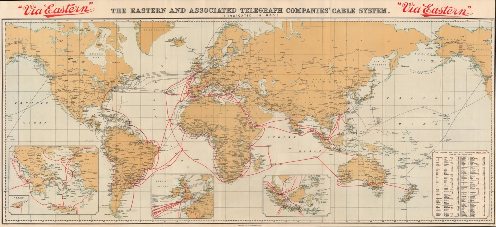
The Eastern and Associated Telegraph Companies' Cable System.
1920 (dated) 18 x 39 in (45.72 x 99.06 cm) 1 : 44000000
1920 (dated) 18 x 39 in (45.72 x 99.06 cm) 1 : 44000000
Description
This is a 1920 Waterlow map of the world illustrating the global telegraph network. Red overprinting highlights the lines of the Eastern and Associated Telegraph Companies. Connecting London with the world, the network 'jumps' from port to port, with a few overland connections in British India and Australia.
Insets
Three insets along the bottom border detail three key locations. The central inset focuses on the British Isles and Western Europe and red text labels with which city each outgoing telegraph cable connects. The left inset details Greece and the Aegean Sea, where the Eastern and Associated Telegraph Companies (and the companies they merged with) laid a lot of cable. A smaller inset highlights Cyprus and its telegraph cables. The inset on the right illustrates Indonesia, the Malacca Strait, and Singapore, the hub of the British East India trade.The Eastern and Associated Telegraph Companies
In 1902, the Eastern Telegraph Company and The Eastern Extension, Australasia, and China Telegraph Company (and ten smaller companies - one of which could trace its origins back to 1857) merged to form the Eastern and Associated Telegraph Companies (1902 - 1929). One of its preceding companies (the Eastern Telegraph Company) operated 160,000 nautical miles of cable at its height, which converts to approximately 184,000 miles, or 7.4 times around the Earth! The company ceased to exist in 1929 when it merged with six other broadcast and cable companies to form Imperial and International Communications Ltd.Publication History and Census
This map was created by Waterlow and Sons and published for the Eastern and Associated Telegraph Companies in 1920. We locate an example of the 1920 at the National Library of Australia, as well as 5 examples in OCLC: Brunel University London, the Massachusetts Institute of Technology, the University of Cambridge, the University of Otago, and the University of Queensland. We have located later editions of the present map dated 1922 and c. 1926. All editions are rare on the private market.Cartographer
Waterlow and Sons (1810 - 1961) was a British engraving and printing concern active in London specializing in currency, postage stamps, bond certificates, and occasionally maps. The firm was founded by James Waterlow (1790 - 1876) in 1810 on Birchin Lane, London, as a legal document printer and copyist. By 1852, they had expanded into stamps and his sons, Albert, Alfred, Sydney, and Walter joined the business. One year after James Waterlow's death, in 1877, infighting among the sons led Alfred Waterlow to split off, forming Waterlow Brothers and Layton. The rift was settled by 1920, and the two firms once again merged under the Waterlow and Sons imprint. They were involved in the Portuguese Bank Note Affair of 1925, wherein the Portuguese fraudster Artur Virgílio Alves Reis convinced the firm to print 200,000 banknotes of 500 Portuguese Escudos each, amounting to roughly 88% of Portugal's GDP. The affair was settled in court with a ruling against Waterlow. In 1928, Waterlow lost its most lucrative contract, printing English banknotes, and began to fall into decline. In 1961, they were acquired by Purnell and Sons who, shortly afterwards, sold the firm to De La Rue. Ironically, De La Rue acquired the contract to print Bank of England banknotes again in 2003 – 75 years after Waterlow lost it! More by this mapmaker...
Condition
Very good. Mounted on linen.
References
National Library of Australia, MAP G3201.P93 1920. OCLC 920549595, 429730621.