This item has been sold, but you can get on the Waitlist to be notified if another example becomes available, or purchase a digital scan.
1879 Stanley Map of East Africa Tracing His First Trans-Africa Expedition
EasternHalfEquatorialAfrica-stanley-1879-2$475.00

Title
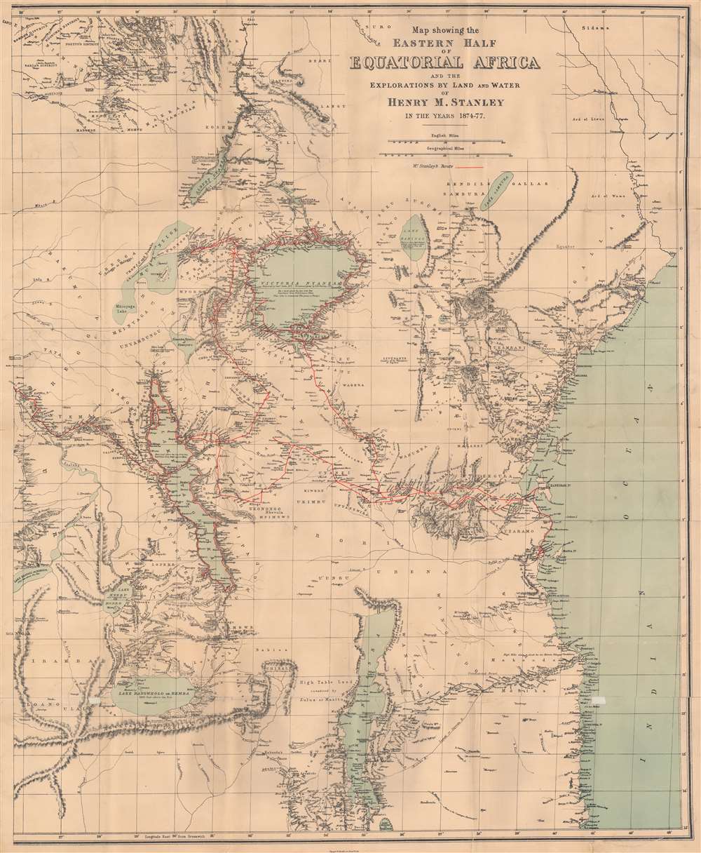
Map showing the Eastern Half of Equatorial Africa and the Explorations by Land and Water of Henry M. Stanley in the years 1874 - 1877.
1879 (dated) 33 x 26.75 in (83.82 x 67.945 cm) 1 : 2850000
1879 (dated) 33 x 26.75 in (83.82 x 67.945 cm) 1 : 2850000
Description
This is a rare 1879 Henry Morton Stanley map of East Africa - one of the first maps to accurately illustrated the Rift Valley. Coverage extends from South Sudan to Zambia and Mozambique and from the Democratic Republic of the Congo to the Indian Ocean. A study in stark contrast, Stanley's route from Zanzibar across the continent to Uzimba in the modern-day Democratic Republic of the Congo, is highly detailed. Points all along the route are labeled, including during his circumnavigation of Lake Victoria and Lake Tanganyika. Notes concerning the region's larger lakes are also included, such as their elevation above sea level and the name of the first European to 'discover' each lake. However, outside of the immediate vicinity of Stanley's expedition, the map is blank, underscoring a general lack of knowledge. Tribes are named, and river courses are included, but the majority of the territory is blank.
Stanley's First Trans-Africa Expedition
This map traces half of Henry Morton Stanley's first trans-Africa expedition, which took place from 1874 to 1877. Its stated goals were to explore Lake Victoria, Lake Albert, Lake Tanganyika, their inflowing and outflowing rivers, and to explore the Lualaba River. Another important goal of the expedition was to establish the source of the Nile River. Sponsored by the New York Herald and the Daily Telegraph, Stanley left Zanzibar on November 12, 1874 at the head of a column of 230 people, most of whom were African porters. By March 1875 he and his party arrived at Lake Victoria, although over sixty members died en route. Stanley spent fifty-seven days exploring Lake Victoria, and then moved on to Lake Tanganyika. He was unable to explore Lake Albert due to a war between Uganda and Wavuma. The party then began work on achieving their final goal of determining whether the Lualaba River fed the Nile, the Congo, or the Niger. This arduous task took nearly a year, and in the end Stanley's party declined to just 115, including three children born during the trip.Publication History and Census
This map was produced for Henry Morton Stanley's Through the Dark Continent; Or, The Sources of the Nile: Around the Great Lakes of Equatorial Africa and Down the Livingstone River to the Atlantic Ocean and most likely published in the 1879 first American edition. We note six examples cataloged in OCLC, at the New York Public Library, Princeton University, the University of Virginia, DePaul University, the University of Texas at Arlington, and the University of California San Diego. This map is rare on the market.CartographerS
Sir Henry Morton Stanley (January 28, 1841 - May 10, 1904) was a British journalist and explorer and a seminal figure in the history of exploration for which we can offer only a cursory treatment here. Stanley is renowned for his explorations of central Africa, locating the missionary and explorer David Livingstone, and his search for the source of the Nile. Born in Wales, Stanley was the illegitimate son of an 18 year old woman and an unknown man, saddling him with the burden of illegitimacy throughout his life. Rowlands moved to the United States in 1859, where he adopted the name Henry Morton Stanley under unclear circumstances. Stanley fought on both sides of the American Civil War and also served in the Union Navy, possibly the only man to serve in all three. After the war, Stanley became a foreign correspondent for the New York Herald, for which he traveled the world, writing stories about his explorations for the paper. More by this mapmaker...
Harper and Brothers (1817 – Present) is New York based American printing publishing firm founded in 1817 by James Harper and his brother John Harper as J. and J. Harper (1817-1833). Their younger brothers Joseph Wesley Harper and Fletcher Harper joined the company around 1926 prompting the 1833 imprint change to Harper and Brothers (1833 – 1962). The firm published countless books, magazines, prints, maps, and more. They began publishing a monthly magazine, Harper's Monthly in 1850. The success of Harper's Monthly led to the introduction of a popular weekly illustrated journal, Harper's Weekly published from 1857 - 1916. They later introduced Harper's Bazar (1867) and Harper's Young People (1879). From about 1899 the business went through a series of permutations selling off some assets and developing others. The company merged with Row, Peters and Company inn 1962, rebranding itself as Harper and Row (1962 – 1990), which was acquired by Marshall Pickering in 1988. It was acquired by Rupert Mordoch (News Corp) and merged with William Collins and Sons in 1990 to form HaprerCollins (1990 – Present), the imprint under which it still publishes. Their original offices were at 331 Franklin Street, roughly below today's Manhattan Bridge. Today they have many offices and are one of the world's largest publishing companies and one of the 'Big Five' English-language publishers. Learn More...
Source
Stanley, H.M., Through the Dark Continent; Or, The Sources of the Nile: Around the Great Lakes of Equatorial Africa and Down the Livingstone River to the Atlantic Ocean. (New York: Harper and Brothers) 1879.
Condition
Good. Mounted on linen. Wear along original fold lines. Slight loss at most fold intersections.
References
OCLC 61668901.