1831 Dower / Teesdale Map of the Eastern Hemisphere
EasternHemisphere-dower-1831$250.00

Title
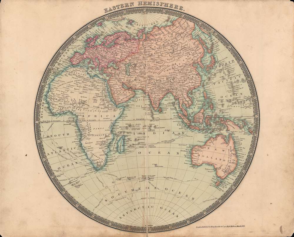
The Eastern Hemisphere.
1831 (dated) 14 x 14 in (35.56 x 35.56 cm) 1 : 60000000
1831 (dated) 14 x 14 in (35.56 x 35.56 cm) 1 : 60000000
Description
This is a beautifully-colored 1831 Henry Teesdale / John Dower map of the Eastern Hemisphere published in their A New General Atlas of the World. It reflects the latest geographical knowledge available at that time and charts the voyages of Captain James Cook.
Also notable is the lines tracing the three voyages of Captain James Cook (and John Gore, who took command after Cook's death on his third voyage and returned the hapless expedition to England).
A Closer Look
This map is a wonderful encapsulation of geographic knowledge in the early 19th century. An impressive number of rivers, islands, cities, and mountains are indicated. Some errors or missing information could be pointed out, but the world appears much as it would on a modern map. Antarctica is not present here. Although several ships spotted it in the 1820s, cartographers were reluctant to include it without further verification, which would take decades.Also notable is the lines tracing the three voyages of Captain James Cook (and John Gore, who took command after Cook's death on his third voyage and returned the hapless expedition to England).
Publication History and Census
Although not indicated on the sheet, this map was engraved by John Dower as the first plate in the 1831 edition of A New General Atlas of the World, published by Henry Teesdale. This appears to be a rare presentation of this map, as most examples from any edition of the atlas do not show such vivid and full color, only hand-colored outlines of territories. The 1831 edition of this map is only independently cataloged in the holdings of the National Library of Australia, while the entire atlas is held by roughly a dozen institutions.CartographerS
John James Dower (June 1, 1825 - 1901) was a well-respected mapmaker, print seller, and publisher based in London, England. Dower is the heir to the more prominent London engraver and mapmaker John Crane Dower (1791 - 1847). Dower worked with many prominent middle to late 19th century London map publishers including Weller, Cassell, Bacon, Petermann, and others. He was elected to the Royal Geographical Society in 1854. Dower also published on maps his own account including one atlas and various school geographies. In addition to his cartographic work, Dower is well known as an engraver of military scenes. More by this mapmaker...
Henry Teesdale (December 1776 - January 1856) was a British map publisher active in the first half of the 19th century. Teesdale was born in London. He was elected to the Royal Geographical Society in 1830. Teesdale initially partnered with John Hordan and William Colling Hobson as Henry Teesdale and Company, but this partnership was dissolved in 1832. Afterwards Teesdale continued to publish maps and atlases on his own account. He worked with several major British map engravers of the period including John Crane Dower, Christopher Greenwood, and Josiah Henshall, among others. His most prominent work is a large map of the world engraved by Dower. He must have enjoyed considerable commercial success because in 1845 he is registered as a partner in the Royal Bank of Scotland. Teesdale died in January of 1856 and was buried in All Souls, Kensal Green. Learn More...
Source
Dower, John, A New General Atlas of the World, (London: Teesdale) 1831.
Condition
Good. Wear along centerfold. Even toning. Some loss at corners.
References
OCLC 225358138.