1873 Meiji 6 Gaiko Oya Map of the Eastern Hemisphere
EasternHemisphere-gaikooya-1873$1,200.00


Title
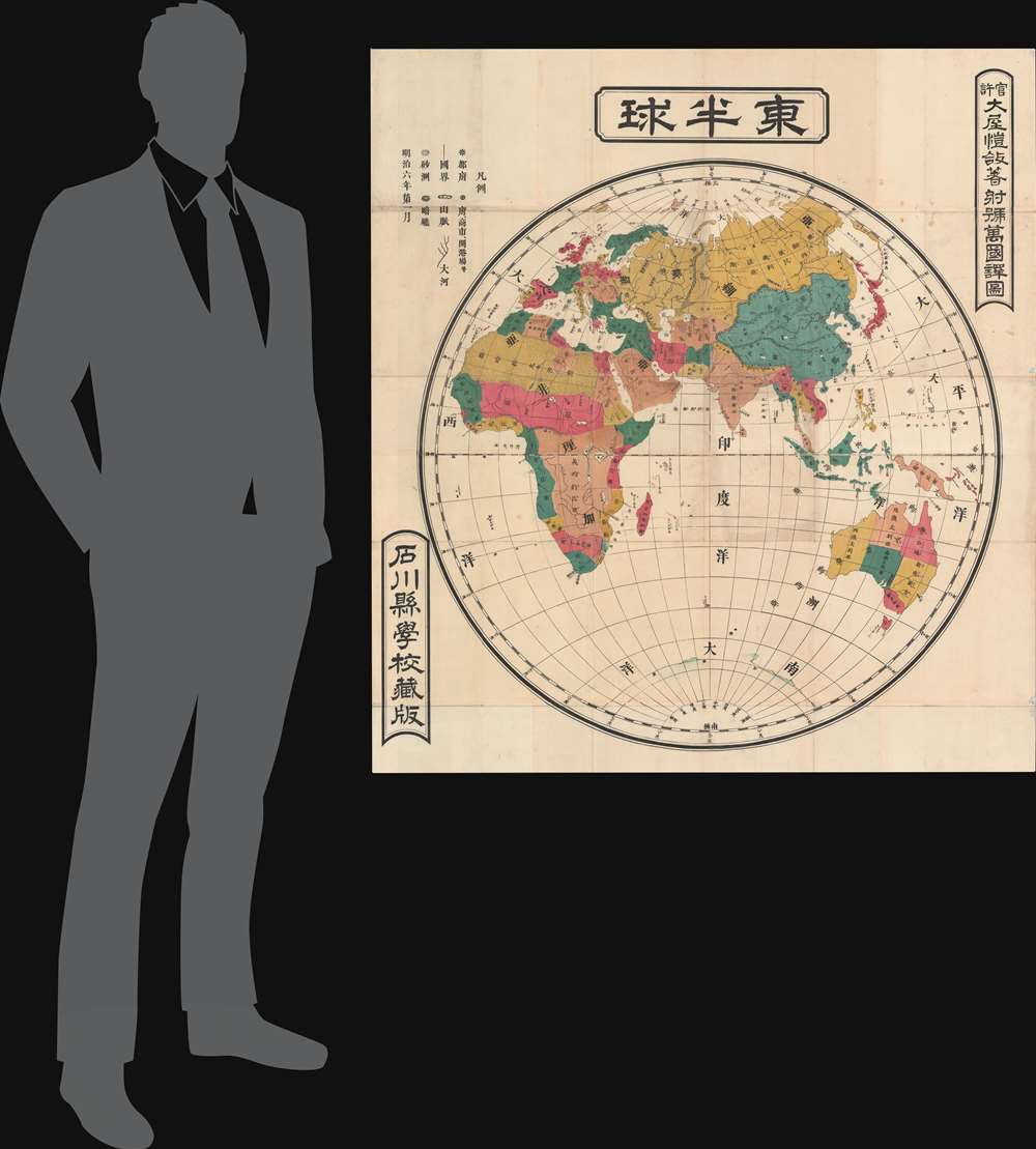
東半球 / Eastern Hemisphere.
1873 (dated) 42.25 x 38.94 in (107.315 x 98.9076 cm) 1 : 25500000
1873 (dated) 42.25 x 38.94 in (107.315 x 98.9076 cm) 1 : 25500000
Description
A rare 1873 or Meiji 6 wall map of the Eastern Hemisphere by the Japanese geographer Gaiko Oya (大屋 愷敆). The map follows the early Meiji Restoration convention of copying cartography from western sources. The practice was intended to modernize Japanese geographical conceptions and place Japan into a geographically accurate global reference.
A Closer Look
Coverage here extends pole to pole and from West Africa to the Solomon Islands. Countries are defined by color coding in a finely executed 4-color system. The map is also quite large, underscoring that it was produced for classroom use at the Ishikawa Prefecture School. The map would have hung on the wall or, more likely, laid on the floor, where school children could walk around the map, studying it from different angles.Japan Finds a Place on the Global Stage
This map illustrates Japan's emergence from an insular feudal nation to a rising power on the world's social, military, and economic stage. The arrival of Commodore Perry and the forced opening of Japan in 1853 transformed Japan's vision of itself, breaking the illusion that it was the sole repository of civilization and underscoring the truth that it was indeed well behind Western powers. The Meiji Restoration followed and was characterized by a major reorganization of government, a reassertion of imperial power, and a drive towards aggressive industrial and social modernization. Japan's victory over Imperial Russia in the Russo-Japanese War (1904 - 1905) marked the first major victory in war by an Asian power over a European Power, an achievement that established Japan as a global power.Publication History and Census
This map was drawn by Gaiko Oya (大屋 愷敆) based on unnamed Western sources and published for the Ishikawa Prefecture School Collection. (官許 大屋愷敆著射號萬國譯圖). The map is rare. We note only one other known example, which is part of the collection at the National Diet Library in Japan.Cartographer
Gaiko Oya (大屋 愷敆; 1839 - 1901) was a Japanese geographer and academic active in the second half of the 19th century. More by this mapmaker...
Condition
Very good. Some wear on old fold lines.