1818 Franz Pluth Map of the Eastern United States
EasternUnitedStates-pluth-1818$750.00

Title
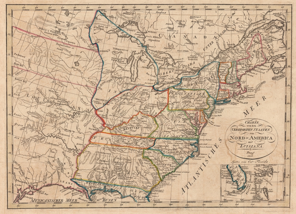
Charte von den Vereinigten Staaten von Nord=America mit Luisiana.
1818 (dated) 12 x 16.75 in (30.48 x 42.545 cm) 1 : 8000000
1818 (dated) 12 x 16.75 in (30.48 x 42.545 cm) 1 : 8000000
Description
This is an 1818 Franz Pluth map of the eastern United States. The is an intriguing Czech production published in Prague. It is both impressively detailed and utterly confusing, reflecting ambiguity regarding U.S territorial claims following the Louisiana Purchase.
A Closer Look
Coverage embraces the post-Louisiana Purchase pre-Mexican-American War United States, and in doing so introduces a great deal of ambiguity regarding boundaries and borders. Ands east of the Mississippi are somewhat strait forward. Georgia stretches from the Atlantic to the Mississippi, thus including modern day Alabama and Mississippi. Indiana is identified as a sprawling territory extending from the Ohio River to roughly 49°N, well north of Lake Superior. It is inexplicably divided by the colorist into two zones by the Illinois River (here the Theakiki, likely a deviation of Kankakee).Uncertain Northern Limit of Louisiana Purchase
Within Louisiana Territory there are inexplicable boundary lines along the 41st and 45th parallels, possibly referencing debate over the northernmost limit of the Louisiana purchase. The northern line, 45°N, may be an extension of the U.S.-Canada border abutting Vermont, New Hampshire, and New York. The lower line, 41°N, represents no boundary line that we are aware of, unless it is meant to delimitate the northern border of Mexican California (California Alta) and the southern border of British Columbia. If the line were extended fully to the Pacific, it would hit just south of Astoria/Fort George, on the Columbia River, giving British claims to the region primacy. The British did, in fact, lay claim to Astoria/Fort George from 1813 to 1818, corresponding with the production of this map.Impressive Detail
Aside from the quandaries presented by the borders, a high level of detail is present. Coastal locations are labeled throughout, including Mount Desert Island, Block Island, Long Island, Albemarle Sound, and Cape Hatteras. Several important cities, both in the northeast and elsewhere, are also noted, such as Boston, Philadelphia, Washington, D.C., Savannah, New Orleans, Pensacola, Nashville, and St. Louis, along with smaller towns. Various Native American tribes are named throughout, including Seminole, Miami, and Sioux.Publication History and Census
This map was produced by Franz Pluth in Prague in 1818. We note four examples cataloged in OCLC which are part of the collections at Harvard University, the University of Illinois at Urbana Champaign, the Library of Congress, and the Birmingham Public Library.Cartographer
Franz Pluth (1800 - 1871) was an engraver based in Prague, the capital of the Kingdom of Bohemia, then part of the Habsburg Austrian Empire. Pluth was born in Prague and most likely died in Zbraslav. He was active as a map engraver until at least 1848. His work is similar in style to that of Karl Ferdinand Weiland, a prolific German engraver, with whom he may have worked. More by this mapmaker...
Condition
Excellent. Even overall toning. Light wear along original fold lines.
References
OCLC 49512511.