This item has been sold, but you can get on the Waitlist to be notified if another example becomes available, or purchase a digital scan.
1901 Railroad Map of the Eastern United States
EasternUnitedStates2-railwaypublishing-1901$75.00

Title
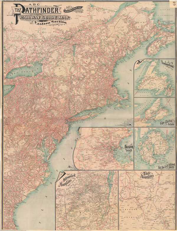
ABC The Pathfinder Railway Guide Map. Eastern Section
1901 (undated) 37.75 x 29 in (95.885 x 73.66 cm) 1 : 2473000
1901 (undated) 37.75 x 29 in (95.885 x 73.66 cm) 1 : 2473000
Description
A very attractive large format 1901 railroad map of the eastern part of the United States. The map covers the Atlantic Seaboard from Nova Scotia to Florida and extends west as far as Lake Erie. An array of 7 inset maps fill the Atlantic Ocean, extending the scope of the map to include Newfoundland and Cape Breton Island. Other inset maps include Boston, Mount Desert Island (Acadia), the Adirondack Mountains, and the White Mountains. Rail lines appear in red. The lower part of the map below St. Augustine, Florida has been inexplicably removed. Map is in generally good condition and shows evidence of inclusion in an elephant folio atlas. Part of the map has been removed to include a page number. The detailing of the map is incredible, showing myriad rail stops which would allow the user to know, if not every, nearly every stop along their chosen rail route. This map was published by the New England Railway Publishing Company as part of the ABC Pathfinder Series.
Cartographer
The New England Railway Publishing Company (fl. c. 1900 – 1920) was a Boston based publisher of railroad maps and guides. Most of their guides were promoted under the 'ABC Pathfinder' brand, but they also published the 'Nickel Pathfinder' and the 'Baby Pathfinder.'. The company maintained offices at 67 Federal Street, Boston. More by this mapmaker...
Condition
Good. Tear repaired on bottom margin and light wear along the edges. Map cut near Florida border (Jacksonville and St. Augustine are shown along Atlantic coast) so does not represent full area of original print.