
This item below is out of stock, but another example (left) is available. To view the available item, click "Details."
Details
1814 Thomson Map of Southeast Asia (Singapore, Thailand, Malay)
1814 (dated) $450.00
1814 Thomson Map of Southeast Asia (Singapore, Thailand, Malay)
EastIndiaIsles-thomson-1814$225.00

Title
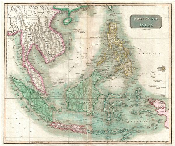
East India Isles.
1814 (undated) 17.5 x 21 in (44.45 x 53.34 cm)
1814 (undated) 17.5 x 21 in (44.45 x 53.34 cm)
Description
This is an exceptionally fine example of John Thomson's 1814 map of Southeast Asia and the East India Islands. Centered on Borneo, Thomson's map covers from China and Hainan south to Sumatra and Java, and eastward as far as the Philippines and New Guinea. Includes the Pearl River Delta at its northern most edge and names Macao and Lantao Island (Hong Kong). The Singapore Straits are identified, as are Bintan and Batam Islands, but the Island of Singapore itself is unnamed.
Just to the east of the Philippine island of Mindanao, sets the apocryphal island of St. John's. The fiction of St. John's Island probably originates with the Portuguese cooption of manuscript mappings of this region acquired form Magellan expedition, though it's first published reference is in Ortelius' 1570 Asiae Nova Descripto. Following St. John's appearance on Ortelius' maps numerous mariners, including Dampier, claimed to have visited it, however, most were most likely mistaking it for other islands in the region. Over the years the location of St. John's Island thus migrated westwards towards Mindanao's eastern coast where it resided until about 1850, when the island finally disappeared from cartographic record. In later editions this map Thomson annotates St. John's island with 'Doubtful,' but in this early edition, at least, he seems quite confident of its placement.
The whole of this map is beautifully engraved in the minimalist English style pioneered in the early part of the 19th century. Relief is shown by hachure with towns, roadways, cities, and major topographical features identified. This map is a steel plate engraving by T. Clerke and was prepared by John Thomson for inclusion in the 1817 edition of Thomson's New General Atlas.
Cartographer
John Thomson (1777 - c. 1841) was a Scottish cartographer, publisher, and bookbinder active in Edinburgh during the early part of the 19th century. Thomson apprenticed under Edinburgh bookbinder Robert Alison. After his apprenticeship, he briefly went into business with Abraham Thomson. Later, the two parted ways, John Thomson segueing into maps and Abraham Thomson taking over the bookbinding portion of the business. Thomson is generally one of the leading publishers in the Edinburgh school of cartography, which flourished from roughly 1800 to 1830. Thomson and his contemporaries (Pinkerton and Cary) redefined European cartography by abandoning typical 18th-century decorative elements such as elaborate title cartouches and fantastic beasts in favor of detail and accuracy. Thomson's principle works include Thomson's New General Atlas, published from 1814 to 1821, the New Classical and Historical Atlas of 1829, and his 1830 Atlas of Scotland. The Atlas of Scotland, a work of groundbreaking detail and dedication, would eventually bankrupt the Thomson firm in 1830, at which time their plates were sequestered by the court. The firm partially recovered in the subsequent year, allowing Thomson to reclaim his printing plates in 1831, but filed again for bankruptcy in 1835, at which time most of his printing plates were sold to A. K. Johnston and Company. There is some suggestion that he continued to work as a bookbinder until 1841. Today, Thomson maps are becoming increasingly rare as they are highly admired for their impressive size, vivid hand coloration, and superb detail. More by this mapmaker...
Source
Thomson, J. A New General Atlas, (Edinburgh) 1817.
Condition
Very good condition. Original centerfold exhibits some minor discoloration. Some offsetting. Original plate mark visible. Blank on verso.
References
Rumsey 1007.043. Phillips (Atlases) 731. Newberry Library: Ayer 135 T4 1817.