This item has been sold, but you can get on the Waitlist to be notified if another example becomes available, or purchase a digital scan.
1804 Arrowsmith Map or Chart of the East Indies
EastIndies-arrowsmith-1804$75.00

Title
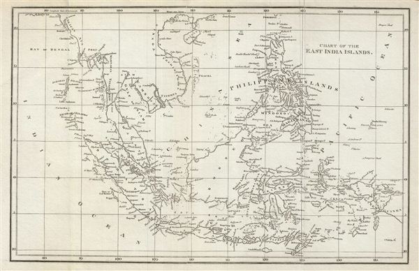
Chart of the East India Islands.
1804 (undated) 10.5 x 16 in (26.67 x 40.64 cm)
1804 (undated) 10.5 x 16 in (26.67 x 40.64 cm)
Description
This is a fine example of the 1804 A. Arrowsmith map of the east Indies. Covers from the southern tip of Taiwan (Formosa) to the Indonesian island of Timor and from the Andaman and Nicobar Islands in the Indian Ocean as far east as Papua New Guinea. Includes Sumatra, Java, Floris & Timor & the Philippine Islands, Borneo, Celebes, Papua & part of New Guinea. Identifies the strait of Singapore and the Bintang Islands, but not the Island of Singapore. Throughout, the map identifies various cities, islands, bays, and an assortment of additional topographical details. This map is created by Aaron Arrowsmith in 1804 for his General Atlas.
Cartographer
Aaron Arrowsmith (1750-1823), John Arrowsmith (1790-1873), and Samuel Arrowsmith. The Arrowsmith family were noted map engravers, publishers, geographers, and cartographers active in the late 18th and early 19th century. The Arrowsmith firm was founded by Aaron Arrowsmith, who was trained in surveying and engraving under John Cary and William Faden. Arrowsmith founded the Arrowsmith firm as a side business while employed by Cary. The firm specialized in large format individual issue maps containing the most up to date and sophisticated information available. Arrowsmith's work drew the attention of the Prince of Wales who, in 1810, named him Hydrographer to the Prince of Wales, and subsequently, in 1820, Hydrographer to the King. Aaron Arrowsmith was succeeded by two sons, Aaron and Samuel, who followed him in the map publication business. The Arrowsmith firm eventually fell to John Arrowsmith (1790-1873), nephew of the elder Aaron. John was a founding member of the Royal Geographical Society. The firm is best known for their phenomenal large format mappings of North America. Mount Arrowsmith, situated east of Port Alberni on Vancouver Island, British Columbia, is named for Aaron Arrowsmith and his nephew John Arrowsmith. More by this mapmaker...
Source
Arrowsmith, A., General Atlas, (London) 1804.
Condition
Very good. Original fold lines visible. Typical wear along folds.