This item has been sold, but you can get on the Waitlist to be notified if another example becomes available, or purchase a digital scan.
1840 Black Map of the East Indies and Southeast Asia
EastIndies-black-1840$112.50

Title
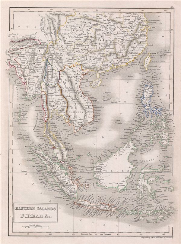
Eastern Islands Birmah & C.
1840 (undated) 16 x 11.5 in (40.64 x 29.21 cm)
1840 (undated) 16 x 11.5 in (40.64 x 29.21 cm)
Description
A fine example of Adam and Charles Black's 1840 map of the east Indies, Southeast Asia, and the Philippines. Includes modern day nations of Myanmar (Burma), Laos, Vietnam, Cambodia, Thailand, Malaysia, Indonesia, the Philippines and parts of China. During this time in history, Burma was under British rule, while much of modern day Indonesia including Sumatra and parts of Borneo were part of the Dutch colony of the Dutch east Indies. The French dominated Indochina, including Cambodia and Vietnam and most of the modern day Philippines were a Spanish territory called Spanish east Indies. Only Thailand (Siam) and China retained national sovereignty. This map was engraved by S. Hall for issue in the 1840 edition of Black's General Atlas.
Cartographer
Charles and Adam Black (fl. 1807 - present) were map and book publishers based in Edinburgh. Charles and his uncle, Adam, both of Edinburgh, Scotland, founded their publishing firm in 1807. They published a series of maps and atlases throughout the 19th century. In addition to an array of atlases, the Black firm is known for their editions of the Encyclopedia Britannica (1817 - 1826) and the first publishing of Sir Walter Scott's novels in 1854. In 1889 the A. & C. Black publishing house moved to London where it remains in operation to this day. More by this mapmaker...
Source
Hall, Sydney, Black's General Atlas: A series of Fifty-Four Maps from the Latest and Most Authentic Sources, Engraved on Steel, In the First Style of the Art, (Edinburgh: Adam and Charles Black) 1840.
Condition
Very good. Blank on verso. Original platemark visible.
References
Rumsey 2305.046 (1854 edition). Philips (atlases) 4334.