This item has been sold, but you can get on the Waitlist to be notified if another example becomes available, or purchase a digital scan.
1657 Sanson Map of the East Indies (Sumatra, Java, Borneo)
EastIndies-sanson-1657$225.00

Title
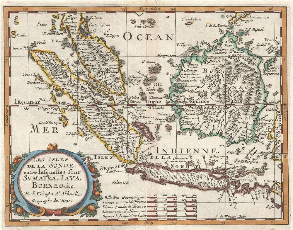
Les Isles de la Sonde entre lesquelles sont Sumatra, Java, Borneo, etc.
1657 (undated) 8 x 10.25 in (20.32 x 26.035 cm) 1 : 13000000
1657 (undated) 8 x 10.25 in (20.32 x 26.035 cm) 1 : 13000000
Description
This is a 1657 Nicolas Sanson D'Abbeville map of the East Indies. The map depicts the region from the Indian Ocean to Celebes and from Malay Peninsula to Java. Highly detailed, myriad locations throughout the region are labeled, including Malacca and Jakarta. Singapore (labeled here as Sincapura) is illustrated as being part of mainland Malaysia and not a separate island. Trees and mountains are shown in profile and numerous rivers trace their way across Malaya, Borneo, Sumatra, and Java.
When Sanson drew this map French cartographers remained dependent on geographical knowledge of the East Indies from Portugal and Flanders. It was not until the 18th century that French cartographers began to recieve more comprehensive first hand reports from merchants and travellers.
This map was first issued by Sanson in 1752, when it was engraved by A. Peyrounin. The current example, updated and revised by A. de Winter was published in Paris by Nicolas Sanson in 1657.
Cartographer
Nicolas Sanson (December 20, 1600 - July 7, 1667) and his descendants were the most influential French cartographers of the 17th century and laid the groundwork for the Golden Age of French Cartography. Sanson was born in Picardy, but his family was of Scottish Descent. He studied with the Jesuit Fathers at Amiens. Sanson started his career as a historian where, it is said, he turned to cartography as a way to illustrate his historical studies. In the course of his research some of his fine maps came to the attention of King Louis XIII who, admiring the quality of his work, appointed Sanson Geographe Ordinaire du Roi. Sanson's duties in this coveted position included advising the king on matters of geography and compiling the royal cartographic archive. In 1644, he partnered with Pierre Mariette, an established print dealer and engraver, whose business savvy and ready capital enabled Sanson to publish an enormous quantity of maps. Sanson's corpus of some three hundred maps initiated the golden age of French mapmaking and he is considered the 'Father of French Cartography.' His work is distinguished as being the first of the 'Positivist Cartographers,' a primarily French school of cartography that valued scientific observation over historical cartographic conventions. The practice result of the is less embellishment of geographical imagery, as was common in the Dutch Golden Age maps of the 16th century, in favor of conventionalized cartographic representational modes. Sanson is most admired for his construction of the magnificent atlas Cartes Generales de Toutes les Parties du Monde. Sanson's maps of North America, Amerique Septentrionale (1650), Le Nouveau Mexique et La Floride (1656), and La Canada ou Nouvelle France (1656) are exceptionally notable for their important contributions to the cartographic perceptions of the New World. Both maps utilize the discoveries of important French missionaries and are among the first published maps to show the Great Lakes in recognizable form. Sanson was also an active proponent of the insular California theory, wherein it was speculated that California was an island rather than a peninsula. After his death, Sanson's maps were frequently republished, without updates, by his sons, Guillaume (1633 - 1703) and Adrien Sanson (1639 - 1718). Even so, Sanson's true cartographic legacy as a 'positivist geographer' was carried on by others, including Alexis-Hubert Jaillot, Guillaume De L'Isle, Gilles Robert de Vaugondy, and Pierre Duval. More by this mapmaker...
Condition
Very good. Even overall toning. Blank on verso.
References
OCLC 1061969480. Durand, F., and Curtis, R., Map of Malaya and Borneo Discovery, Statehood and Progress, #26.