This item has been sold, but you can get on the Waitlist to be notified if another example becomes available, or purchase a digital scan.
1619 Schouten and Blaeu Map of the East Indies: Malaya, Java, Borneo, Singapore
EastIndies-schouten-1619$875.00

Title
Archipelage Des Moluques.
1619 (undated) 13 x 17 in (33.02 x 43.18 cm)
1619 (undated) 13 x 17 in (33.02 x 43.18 cm)
Description
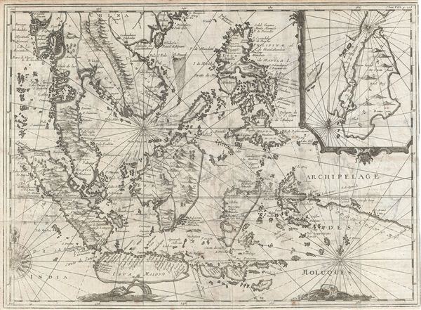
An extremely scarce and obscure c. 1619 map of the east Indies by Willem Cornelisz Schouten and Willem Janszoon Blaeu. Centered on Borneo, the map coves all of Southeast Asia and the east Indies from Pegu and Arakan in the North to Java and Timor in the South and from the Andaman Islands in the west to the Philippines and New Guinea in the east. This includes the modern day nations of Thailand, Burma (Myanmar), Malaysia, Cambodia, Vietnam, Laos, Indonesia, Borneo, and the Philippines. An inset in the upper right detail Buton Island or, as it is written here, Botton Island.
As the map has no clear title and is very rare, with no other known example archived in any collection public and private, researching it has proven challanging. Cartographically this map corresponds point-for-point with the east Indies section of Willem Blaeu's 1609 wall map of Asia. The map's various decorative elements and its engraving style are also highly indicative of the Blaeu firm. If this is in fact a Blaeu map, it was not published in any of his major atlases and is most likely the earliest example of a Blaeu map to specifically focus on the east India Islands.
The single most identifying factor on this map is the inset in the upper left quadrant of the Button Strait (Buton Strait). Booton or Buton Island is a small island set in the Flores Sea just the southeast of the Celebes or Sulawesi. The inset map details a strait, the Strait of Buton, separating the island form the nearby Pulau Muna or Moena eiland (here labeled Camboy), located just to the west. The singular historic event relating to this strait is its discovery by Willem Cornelisz Schouten and Jacob le Maire in 1616. Between 1615 and 1617 Schouten and Le Maire circumnavigated the globe in a search not only for elusive and apocryphal Terra Australis, but also for an alternative route to the Spice Island that would enable them to undermine the trade monopoly of the Dutch east India Company (VOC). In 1616 Schouten rounded Cape Horn, which he names for his birthplace Hoorn, and coasted New Ireland and New Guinea, in the process identifying several new islands which he named Willem Schoute eylandt (Schouten Islands). On the present example these are identified just to the north of New Guinea – a significant and telling point of variance between this and the 1609 Blaeu wall map of Asia.
Schouten then purportedly discovered the Strait of Buton, of which he wrote:
Voici une Carte des Isles Moluques & de Botton, que moi Jean Cornelisz de Moye ai dessinee avec toute I'exactitude possible, pendant les diverses navigations que j'y ai faites, sur tout dans le detroit de BottonThusly we may ascribe, with some confidence, the primary map to Blaeu, the inset in the upper right to Schouten, and the engraving to the Blaeu firm for inclusion in Blaeu's 1619 publication of Schouten's journals. All and all a wonderful, fascinating, and appealing decorative map of the east Indies that will not likely appear on the market again.
Here is a Map of Molucca Isles and Button, as I Jean Cornelisz de Moye describe with all possible exactitude, during various voyages I have made to the Button Strait. [our own translation].
CartographerS
Willem Cornelisz Schouten (c. 1567 - 1625) was a Dutch navigator and explorer active in the early 17th century. Schouten was born in Hoorn, Holland. In 1615 Willem Cornelisz Schouten and Jacob le Maire sailed from Texel in the Netherlands, in command of an expedition sponsored by Isaac Le Maire and his Australische Compagnie in equal shares with Schouten. A main purpose of the voyage was to search for the apocryphal southern continent of Terra Australis. A further objective was to evade the trade restrictions of the Dutch East India Company (VOC) by discovering a new route to the Moluccas or Spice Islands. In 1616 Schouten rounded Cape Horn, which he named for his birthplace, the Dutch city of Hoorn. He followed the north coasts of New Ireland and New Guinea and visited adjacent islands, naming some the Schouten Islands. Although Schouten did in fact discover a new and previously unknown trade route, the ever jealous VOC claimed infringement of its monopoly of trade to the Spice Islands. Schouten was arrested (and later released) and his ship confiscated in Java. Jacob le Maire's wealthy father lobbied for their cause and Schouten was eventually freed. On his release he would sail to the Indies, this time for the VOC, where he fought several naval battles with other colonial powers over trade rights in the region. During one such battle was killed off the coast of Madagascar in 1625. Schouten's journals were published in 1618 and 1619 by Willem Jansz Blaeu. More by this mapmaker...
Willem Janszoon Blaeu (1571 - October 18, 1638), also known as Guillaume Blaeu and Guiljelmus Janssonius Caesius, was a Dutch cartographer, globemaker, and astronomer active in Amsterdam during the late 16th and early 17th centuries. Blaeu was born 'Willem Janszoon' in Alkmaar, North Holland to a prosperous herring packing and trading family of Dutch Reformist faith. As a young man, he was sent to Amsterdam to apprentice in the family business, but he found the herring trade dull and instead worked for his cousin 'Hooft' as a carpenter and clerk. In 1595, he traveled to the small Swedish island of Hven to study astronomy under the Danish Enlightenment polymath Tycho Brahe. For six months he studied astronomy, cartography, instrument making, globe making, and geodesy. He returned to Alkmaar in 1596 to marry and for the birth of his first son, Johannes (Joan) Blaeu (1596 – 1673). Shortly thereafter, in 1598 or 1599, he relocated his family to Amsterdam where he founded the a firm as globe and instrument makers. Many of his earliest imprints, from roughly form 1599 - 1633, bear the imprint 'Guiljelmus Janssonius Caesius' or simply 'G: Jansonius'. In 1613, Johannes Janssonius, also a mapmaker, married Elizabeth Hondius, the daughter of Willem's primary competitor Jodocus Hondius the Elder, and moved to the same neighborhood. This led to considerable confusion and may have spurred Willam Janszoon to adopt the 'Blaeu' patronym. All maps after 1633 bear the Guiljelmus Blaeu imprint. Around this time, he also began issuing separate issue nautical charts and wall maps – which as we see from Vermeer's paintings were popular with Dutch merchants as decorative items – and invented the Dutch Printing Press. As a non-Calvinist Blaeu was a persona non grata to the ruling elite and so he partnered with Hessel Gerritsz to develop his business. In 1619, Blaeu arranged for Gerritsz to be appointed official cartographer to the VOC, an extremely lucrative position that that, in the slightly more liberal environment of the 1630s, he managed to see passed to his eldest son, Johannes. In 1633, he was also appointed official cartographer of the Dutch Republic. Blaeu's most significant work is his 1635 publication of the Theatrum orbis terrarum, sive, Atlas Novus, one of the greatest atlases of all time. He died three years later, in 1638, passing the Blaeu firm on to his two sons, Cornelius (1616 - 1648) and Johannes Blaeu (September 23, 1596 - December 21, 1673). Under his sons, the firm continued to prosper until the 1672 Great Fire of Amsterdam destroyed their offices and most of their printing plates. Willem's most enduring legacy was most likely the VOC contract, which ultimately passed to Johannes' son, Johannes II, who held the position until 1617. As a hobbyist astronomer, Blaeu discovered the star now known as P. Cygni. Learn More...
Source
Shouten, J. C., Novi Freti, a parte meridionali freti Magellanici in Magnum Mare Australe Detectio. Diarium vel descriptio laboriosissimi et molestissimi itineris, facti a Guilielmo Cornelii Schoutenio annis 1615-17, (Amsterdam: Blaeu), c. 1619.
Condition
Very good. Exhibits original fold lines. Some transference.