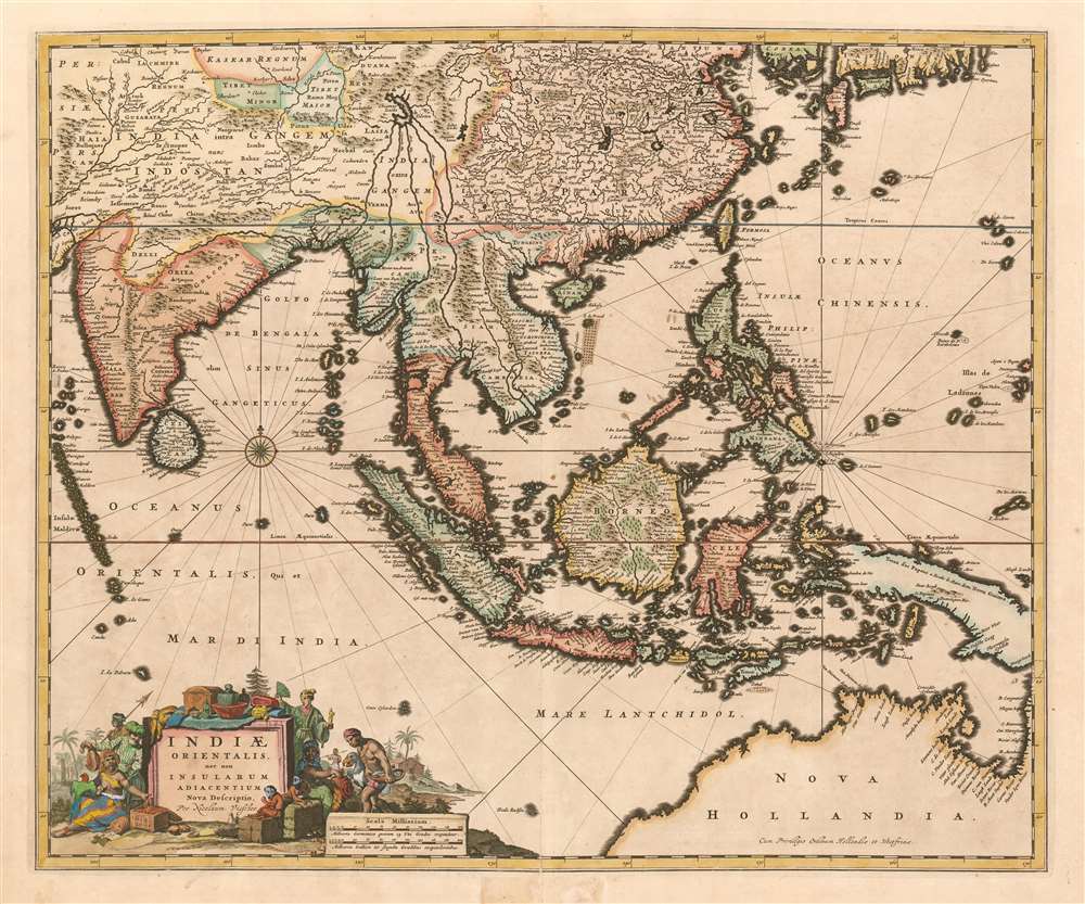
1657 Visscher Map of the East Indies, Southeast Asia, and Australia
EastIndies-visscher-1657$1,500.00

Title
Indiae Orientalis, nec non Insularum Adiacenum Nova Descriptio per Nicolaum Visscher.
1657 (dated) 18.25 x 22 in (46.355 x 55.88 cm) 1 : 15000000
1657 (dated) 18.25 x 22 in (46.355 x 55.88 cm) 1 : 15000000
Description
This is Nicolas Visscher's c. 1657 map of the East Indies, one of the defining Dutch maps of the primary source of Dutch wealth for the second half of the 17th century. The map shows India and the Indian Ocean, the East Indies, the north coast of Australia showing the Gulf of Carpentaria, and New Guinea. China is shown, as are the southern coasts of Korea and Japan.
Geographical Improvements
The Visscher family generally employed larger plates and finer detail than the mapmakers of the first half of the 17th century, generally improving the clarity of the maps and allowing the addition of more geographical detail. This map's inclusion in Jansson's 1657 atlas attests to its quality - in both scope and detail it far outstrips Jansson's own 1630 map, which remained unchanged in that firm's atlases. Visscher takes advantage of the larger plate size, extending the western reach of the map to encompass the Indian peninsula and much of the Indian Ocean, including the Maldives. The map extends southwards to be able to include the Australian coastline uncovered during Tasman's 1644 voyage, thus bringing the map considerably more up-to-date than the Jansson map it replaced. This map improves even on areas that the Jansson covered by showing them in considerably finer detail, with many more place names - the engravers' art having advanced to allow smaller, more legible lettering. China's mapping is state-of-the art, largely based on Martino Martini's geographical information, new to Europe in the 1650s. The southern coast of Korea resembles that which appears in the Martini maps, suggesting a correction from the old insular model appearing on Jansson's earlier maps.Cartouche
The map's elegant cartouche emphasizes both the exoticism of the regions covered in the map, and the riches to be had there. The title is presented on a plinth, piled high with silks, chests and jugs; and crates of spices are stacked about it. Figures in the garb of Moguls, Sumatrans, Moluccans and a Japanese noble flank the cartouche. Monkeys cavort on spice bales; one of the figures carries a parrot. To the right, a native carries a tray of fish - Visscher's cartouches frequently sported a fisherman, as an allusion to the family name. This particular 'Visscher' also carries what appears to be a dodo.Publication History and Census
This map appears to have first been included in Jansson's Novus Atlas of 1657-58, and was later included with Visscher's Atlas Contractus. The presence of the 'Cum Priviligeo' indicates a date no earlier than 1677, and that the map was probably included by one of the younger Visschers in their Atlas Minor, the composite atlas published by the family starting in the mid-1670 and continuing without change into the 18th century. Fifteen examples of the Atlas Minor appear in OCLC with varying pagination; OCLC also catalogues perhaps thirty examples of this separate map in various issues.Cartographer
Claes Jansz Visscher (1587 - 1652) established the Visscher family publishing firm, which were prominent Dutch map publishers for nearly a century. The Visscher cartographic story beings with Claes Jansz Visscher who established the firm in Amsterdam near the offices of Pieter van den Keer and Jadocus Hondius. Many hypothesize that Visscher may have been one of Hondius's pupils and, under examination, this seems logical. The first Visscher maps appear around 1620 and include numerous individual maps as well as an atlas compiled of maps by various cartographers including Visscher himself. Upon the death of Claes, the firm fell into the hands of his son Nicholas Visscher I (1618 - 1679), who in 1677 received a privilege to publish from the States of Holland and West Friesland. The firm would in turn be passed on to his son, Nicholas Visscher II (1649 - 1702). Visscher II applied for his own privilege, receiving it in 1682. Most of the maps bearing the Visscher imprint were produced by these two men. Many Visscher maps also bear the imprint Piscator (a Latinized version of Visscher) and often feature the image of an elderly fisherman - an allusion to the family name. Upon the death of Nicholas Visscher II, the business was carried on by the widowed Elizabeth Verseyl Visscher (16?? - 1726). After her death, the firm and all of its plates was liquidated to Peter Schenk. More by this mapmaker...
Source
Visscher, Nicolas I and II, Atlas Minor, (Amsterdam) c. 1677-1700.
Condition
Very good condition. Marginal mend at top, mended split at lower centerfold, just entering printed area.
References
Rumsey 11755.116. OCLC Koeman Vis 19, P. 169-170.