This item has been sold, but you can get on the Waitlist to be notified if another example becomes available, or purchase a digital scan.
1701 Wells Map of India and the East Indies
EastIndies-wells-1701$325.00

Title
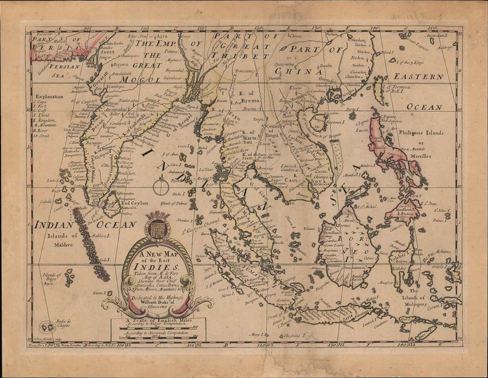
A New Map of the East Indies, Taken from Mr. de Fer's Map of Asia, Shewing their Chief Divisions, Cities, Towns, Ports, Rivers, Mountains etc.
1701 (undated) 14 x 19 in (35.56 x 48.26 cm) 1 : 13000000
1701 (undated) 14 x 19 in (35.56 x 48.26 cm) 1 : 13000000
Description
This is an attractive and scarce c. 1701 map of India, Southeast Asia, and the East Indies by Edward Wells. Based on the cartography on Nicolas de Fer, it is a good representation of Europeans' perception of the geography of South and Southeast Asia at the time.
The island of Singapore is illustrated but not labeled. Bali (Baly) and Lombok (Lombock) as well as Batavia are identified. Most of the Great Sunda Islands as well as the Lesser Sunda Islands, which were largely unexplored well into the 19th century, are mapped speculatively. India is depicted too narrow, and Taiwan is misshapen. The Maldives, Laccadives, Chagos Archipelago, and other islands are greatly exaggerated in size, reflecting their importance to European navigators. Likewise, Parta Island (Pratas), an island and surrounding shoals now administered by Taiwan, is unusually large here. A curious swath of shallow water and hazards is included parallel to the Vietnamese coast in the South China Sea, from what is perhaps the island of Dao Phu Qui or the westernmost of the Spratly Islands north to the Paracel Islands.
Both Ferro and London are used as Prime Meridians, while two scales of English miles are determined according to different calculations. A brief legend at left-top explains the abbreviations.
A large title cartouche is included towards bottom-left featuring the coat of arms of the Duke of Gloucester, that is, Prince William, who was a student at Oxford, where Wells taught mathematics and geography, when this map was being prepared. The sickly prince died in 1700 at only 11 years old and Wells devoted A New Sett of Maps to his memory. Incidentally, the death of William set off a succession crisis leading Parliament to pass the Act of Settlement, which aimed to prevent a Catholic becoming monarch and placed the House of Hanover next in line of succession, determining the line of British kings and queens for the next two centuries.
A Closer Look
Centered on the Malay Peninsula, this map covers all of South and Southeast Asia from Persia to Timor Island, inclusive of the modern-day nations of India, Sri Lanka, Thailand, Burma (Myanmar), Malaysia, Cambodia, Vietnam, Laos, Indonesia, and the Philippines. Based on Nicholas De Fer's map of Asia, it renders the region in detail, offering both topographical and political information with mountains beautifully rendered in profile.The island of Singapore is illustrated but not labeled. Bali (Baly) and Lombok (Lombock) as well as Batavia are identified. Most of the Great Sunda Islands as well as the Lesser Sunda Islands, which were largely unexplored well into the 19th century, are mapped speculatively. India is depicted too narrow, and Taiwan is misshapen. The Maldives, Laccadives, Chagos Archipelago, and other islands are greatly exaggerated in size, reflecting their importance to European navigators. Likewise, Parta Island (Pratas), an island and surrounding shoals now administered by Taiwan, is unusually large here. A curious swath of shallow water and hazards is included parallel to the Vietnamese coast in the South China Sea, from what is perhaps the island of Dao Phu Qui or the westernmost of the Spratly Islands north to the Paracel Islands.
Both Ferro and London are used as Prime Meridians, while two scales of English miles are determined according to different calculations. A brief legend at left-top explains the abbreviations.
A large title cartouche is included towards bottom-left featuring the coat of arms of the Duke of Gloucester, that is, Prince William, who was a student at Oxford, where Wells taught mathematics and geography, when this map was being prepared. The sickly prince died in 1700 at only 11 years old and Wells devoted A New Sett of Maps to his memory. Incidentally, the death of William set off a succession crisis leading Parliament to pass the Act of Settlement, which aimed to prevent a Catholic becoming monarch and placed the House of Hanover next in line of succession, determining the line of British kings and queens for the next two centuries.
Publication History and Census
This map was prepared by Edward Wells, engraved by Sutton Nicholls, and published by T. Bonwicke for either the 1700 (first) or 1701 (second) edition of Edward Wells' atlas, A New Sett of Maps both of Ancient and Present Geography, distinguished by the inclusion of the number '30' in the cartouche below the title. Despite having five listings in the OCLC between them, the 1700 and 1701 editions of the map are only indicated in the holdings of five institutions, while the entire 1700 and 1701 editions of the entire A New Sett of Maps are somewhat more widely distributed.CartographerS
Edward Wells (1667 - 1727) was an English mathematician, geographer, and classical scholar based at Christ Church College, Oxford. Wells trained for the ministry but quickly found himself unsuited to religious life and instead applied for an academic position at Oxford, where he authored numerous well respected works on a wide range of mathematical and scientific topics. He tutored Prince William, the sickly son of Queen Anne, who was likely about 11 at the time this map was prepared. Wells dedicated nearly all of the maps in his atlas, A New Sett of Maps both of Ancient and Present Geography, to the young prince - quite possibly posthumously, as William died in July of 1700 shortly prior to the publication of the atlas. Nonetheless, Wells' geography proved popular and was published in number editions well into the 1730s. More by this mapmaker...
Nicholas de Fer (1646 - October 25, 1720) was a French cartographer and publisher, the son of cartographer Antoine de Fer. He apprenticed with the Paris engraver Louis Spirinx, producing his first map, of the Canal du Midi, at 23. When his father died in June of 1673 he took over the family engraving business and established himself on Quai de L'Horloge, Paris, as an engraver, cartographer, and map publisher. De Fer was a prolific cartographer with over 600 maps and atlases to his credit. De Fer's work, though replete with geographical errors, earned a large following because of its considerable decorative appeal. In the late 17th century, De Fer's fame culminated in his appointment as Geographe de le Dauphin, a position that offered him unprecedented access to the most up to date cartographic information. This was a partner position to another simultaneously held by the more scientific geographer Guillaume De L'Isle, Premier Geograph de Roi. Despite very different cartographic approaches, De L'Isle and De Fer seem to have stepped carefully around one another and were rarely publicly at odds. Upon his death of old age in 1720, Nicolas was succeeded by two of his sons-in-law, who also happened to be brothers, Guillaume Danet (who had married his daughter Marguerite-Geneviève De Fer), and Jacques-François Bénard (Besnard) Danet (husband of Marie-Anne De Fer), and their heirs, who continued to publish under the De Fer imprint until about 1760. It is of note that part of the De Fer legacy also passed to the engraver Remi Rircher, who married De Fer's third daughter, but Richer had little interest in the business and sold his share to the Danet brothers in 1721. Learn More...
Source
Wells, E., A New Sett of Maps both of Ancient and Present Geography, (London: T. W. Bonwicke) c. 1701.
Condition
Average. Acid burn from old framing. Loss in lower margin reinstated.
References
Rumsey 11181.033. OCLC 606383083, 224651991, 947874775, 7465243, 43200747.