1878 Hayden Economic / Geological Map of Green River, Bear Lake, Jackson Hole Region
EconomicMapWYIDUT-hayden-1879$400.00


Title
Economic map of portions of Wyoming, Idaho and Utah.
1879 (dated) 20.5 x 36 in (52.07 x 91.44 cm) 1 : 506880
1879 (dated) 20.5 x 36 in (52.07 x 91.44 cm) 1 : 506880
Description
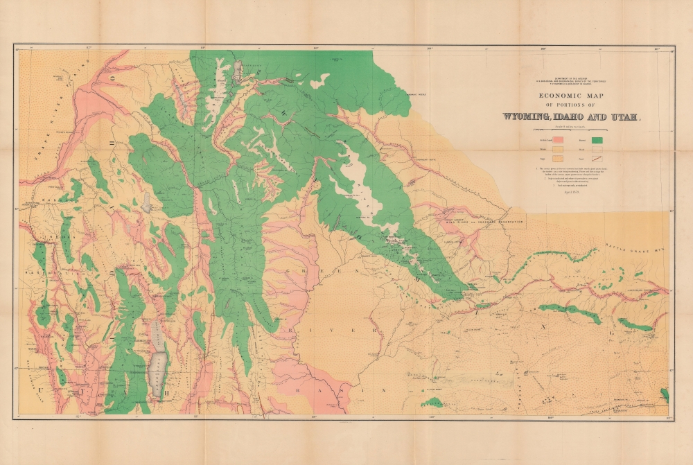
An impressive, large-scale 1879 map of the border region between Idaho, Utah, and Wyoming illustrating economic growth factors. Though similar in appearance to other geological maps produced by the USGGST, it focuses on 'economic' factors such as coal and arable land. It was produced by Ferdinand Vandeveer Hayden and the U.S. Geological and Geographical Survey of the Territories (USGGST), the forerunner to the U.S. Geological Survey.
A Closer Look
Ranging from the Snake River Plains and the 'Bannack' (now the Fort Hall Shoshone-Bannock) Reservation in the west to the Rattle Snake Mountains and the area around Rawlins in the east, this map takes in the Green River Basin, Bear Lake, Jackson Hole, and the Wind River Shoshone Reservation. Mountains and settlements (with their elevations), waterways, roads, railroads, and more are indicated. Though still quite remote, the development of towns in the region is apparent, especially along roads, rail lines, and waterways. Color shading indicates the nature of the land (arable land, forest, rock, grass, sage) and the location of coal deposits.The U.S. Geological and Geographical Survey of the Territories
The U.S. Geological and Geographical Survey of the Territories (also known as the Hayden Survey) was created under the U.S. Department of the Interior in 1870, with Hayden as its director. It operated through 1879. The first year the Survey operated in Wyoming on a budget of $25,000 with twelve assistants and eight teamsters and cooks. The following year (1871), the Survey received $40,000 and employed thirty-two individuals, including artist Thomas Moran and photographer W. H. Jackson. That year they launched from Ogden, Utah (which the Union Pacific Railroad had reached) and spent the summer in what is now Yellowstone National Park. The work conducted by the survey that year played a critical role in convincing the U.S. Senate to create Yellowstone, the first U.S. National Park. The Survey worked in Colorado from 1873 through 1876 because of hostilities between white settlers and Native Americans in Wyoming. The team returned to the Yellowstone in 1877 and 1878. Then, in 1879, the Hayden Survey, along with surveys led by John Wesley Powell (the Colorado River and the Grand Canyon) and Clarence King (Fortieth Parallel Survey), were merged to create the U.S. Geological Survey.Publication History and Census
This map was produced by the USGGST, led by Ferdinand Vandeveer Hayden. Though dated April 1879, it appeared in the Twelfth Annual Report of the USGGST for the year 1878 (the map is also sometimes dated to 1883 as the 1878 report was not published by the Government Printing Office until 1883). Due to these discrepancies over publication date, as well as cataloging variations in the title and attribution of authorship, and the co-mingling of digital and physical copies, the map appears in eight listings in the OCLC. All told, it is independently cataloged among the holdings of some twelve institutions worldwide, while the entire 1878 Annual Report is somewhat more widely distributed.Cartographer
Ferdinand Vandeveer Hayden (September 7, 1829 - December 22, 1887) was an American geologist remembered for leading late 19th century pioneering surveying expedition in the Rocky Mountains and served as a doctor in the Union Army during the U.S. Civil War. Born in Westfield, Massachusetts, and discovered a fascination with nature and wildlife in his youth. He studied at Oberlin College and graduated in 1850, then attended the Albany Medical College and earned his degree in 1853. While at Albany, Hayden garnered the attention of Professor James Hall, then the state geologist of New York. Professor Hall convinced Hayden to join an expedition to the Nebraska Territory, where he collected fossils and studied geology. He accompanied expeditions led by Gouverneur K. Warren in 1856 and 1857 and the Raynolds Expedition of 1860 led by Captain William F. Raynolds. He served as an army surgeon during the U.S. Civil War and rose to become the chief medical officer of the Army of the Shenandoah. After the war, Hayden resumed working on geologic and geographic surveys in the Nebraska and Western Territories and was appointed geologist-in-chief of the United States Geological and Geographical Survey of the Territories in 1867. Hayden led the first federally funded geological survey into the Yellowstone Region in northwestern Wyoming in 1871 under orders from Secretary of the Interior Columbus Delano. The expedition included fifty men, including painter Thomas Moran and Civil War photographer William Henry Jackson. Hayden's report on the expedition, Preliminary Report of the United State Geological Survey of Montana and Portions of Adjacent Territories; Being a Fifth Annual Report of Progress played an instrumental role in persuading Congress to establish Yellowstone as the first U.S. National Park. More by this mapmaker...
Source
Hayden, F. V., Twelfth Annual Report of the United States Geological and Geographical Survey of the Territories: A report of progress of the exploration in Wyoming and Idaho for the year 1878, (Washington, D.C.: Government Printing Office) 1883.
Condition
Good. Wear and some uneven toning along fold lines.