
1935 Reid Pictorial Map of Edinburgh and Leith, Scotland

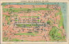
Pictorial Map of Edinburgh and Leith.
Edinburgh's Pioneering Blend of Conservation and Slum Clearance.
$300.00
Choose a Collection:
- Digital Map Information
- Suitable for large format printing
- Full resolution TIFF file
- ICC color profile embedded
- Delivered instantly via download link
This Item
Enquire
Edinburgh's Pioneering Blend of Conservation and Slum Clearance.
This is a 1935 Art Deco-style pictorial map of Edinburgh, Scotland, published by George A. Reid. It was issued at a time when Edinburgh, led by urban planner Patrick Geddes, implemented innovative urban renewal projects while preserving the city's distinctive historic architecture.A Closer Look
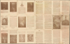
The map covers Edinburgh and the port of Leith from the Firth of Forth in the north to the Royal Observatory and Craigmillar Castle in the south, with important monuments and buildings represented in profile, including Edinburgh Castle, Holyrood Palace, Waverly Station, and numerous clubs, churches, theaters, schools, parks, and hospitals. Streets are labeled throughout, including those that compose the Royal Mile leading to Parliament Square and the castle. Railway, tramway, and bus lines are traced in color.This pictorial map is notable and unusual as similar works generally depict major international cities like London or Paris. At the same time, even after the incorporation of Leith in 1920, Edinburgh was not even among the five largest British cities at the time of publication. This is the 'Clarinda Edition' of Reid's map, referring to the 'Story of Clarinda' which appears on the verso along with a biography of Mary Queen of Scots. Clarinda was an Edinburgh native who had a clandestine affair with Robert Burns, inspiring, some say, much of his best work.
Historical Context
In the early 20th century, Edinburgh grappled with urban decay and dense tenement overcrowding, a crisis that intensified even as the city expanded its borders, most notably through its historic 1920 amalgamation with the port of Leith. Amidst these pressures, pioneering Scottish urban planner and sociologist Patrick Geddes (1854 - 1932) championed a revolutionary alternative to the era's destructive slum clearances through a philosophy he called 'conservative surgery.' Instead of wholesale demolition, Geddes advocated the selective removal of only the most dilapidated structures to introduce light, fresh air, and pocket gardens into the dense Old Town, thereby revitalizing historic architecture while preserving the community's existing social fabric. His holistic approach was epitomized by projects like Ramsay Garden and the Outlook Tower (labeled here in faint letters as 'Camera Obscura') near Castle Hill, which he turned into a sort of hands-on demonstration space and museum for urban planning.Publication History and Census
This map was published in several editions throughout the early-mid 20th century, none of which are dated, but most of which are numbered ('Second Edition,' 'Third Edition' and so on). The present example is an exception, the 'Clarinda Edition,' which is generally dated to c. 1935. Later editions, c. 1950, were published by the Stanley Press instead of Reid (see our earlier listing Edinburgh-stanleypress-1950). The various editions of the map are held by ten institutions in the OCLC, but this Clarinda Edition is noted only in the holdings of the National Library of Scotland.Cartographer
George A. Reid (fl. c. 1900 - 1940) was a Scottish printer and bookseller active in Edinburgh during the first half of the 20th century. Reid published an Edinburgh directory as well as a number of Masonic titles, suggesting an affiliation with the Scottish Rite. Reid maintained his offices at 53 Elder St., Edinburgh. Further Details...
Condition
Good. Wear along original fold lines. Slight loss at several fold intersections. Verso repairs to fold separations. Text and printed images on verso.
References
OCLC 877345408.