This item has been sold, but you can get on the Waitlist to be notified if another example becomes available, or purchase a digital scan.
1907 U.S. Geological Survey Map of Egg Harbor, Atlantic City, New Jersey
EggHarborAtlanticCity-usgs-1907$175.00

Title
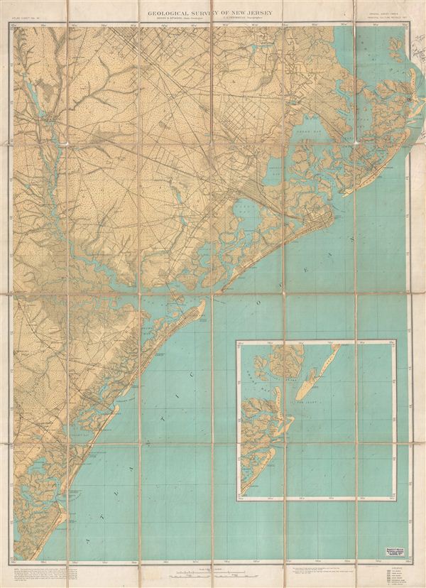
Topographical Map of the 'Egg harbor and Vicinity' New Jersey No 16.
1907 (dated) 36 x 26 in (91.44 x 66.04 cm)
1907 (dated) 36 x 26 in (91.44 x 66.04 cm)
Description
This is a scarce example of the 1907 U. S. Geological Survey southern New Jersey in the vicinity of Atlantic City and egg Harbor. Centered on the Great egg Harbor, the map covers from Great Bay to Peermont, including Ocean City, Atlantic City, Sea Isle City, and Brigantine. An inset of the Great Bay area is included. The map offers copious topographical detail in addition to identifying towns, roads, rivers, railway lines, and some city street grids. Originally dissected and mounted by e. P. Noll and Co., 21 N Seventh Street, Philadelphia, PA, this map was created under the supervision of Henry B. Kummel, New Jersey State Geologist. The topography is the work of C.C. Vermeule.
Cartographer
The Office of the Coast Survey (later the U.S. Geodetic Survey) (1807 - present), founded in 1807 by President Thomas Jefferson and Secretary of Commerce Albert Gallatin, is the oldest scientific organization in the U.S. Federal Government. Jefferson created the "Survey of the Coast," as it was then called, in response to a need for accurate navigational charts of the new nation's coasts and harbors. The first superintendent of the Coast Survey was Swiss immigrant and West Point mathematics professor Ferdinand Hassler. Under the direction of Hassler, from 1816 to 1843, the ideological and scientific foundations for the Coast Survey were established. Hassler, and the Coast Survey under him developed a reputation for uncompromising dedication to the principles of accuracy and excellence. Hassler lead the Coast Survey until his death in 1843, at which time Alexander Dallas Bache, a great-grandson of Benjamin Franklin, took the helm. Under the leadership A. D. Bache, the Coast Survey did most of its most important work. During his Superintendence, from 1843 to 1865, Bache was steadfast advocate of American science and navigation and in fact founded the American Academy of Sciences. Bache was succeeded by Benjamin Pierce who ran the Survey from 1867 to 1874. Pierce was in turn succeeded by Carlile Pollock Patterson who was Superintendent from 1874 to 1881. In 1878, under Patterson's superintendence, the U.S. Coast Survey was reorganized as the U.S. Coast and Geodetic Survey (C & GS or USGS) to accommodate topographic as well as nautical surveys. Today the Coast Survey is part of the National Oceanic and Atmospheric Administration or NOAA. More by this mapmaker...
Condition
Very good. Dissected and mounted on linen in 24 sheets. Linen split at few places. Markings by pen in right margin. Some erased pencil marks here and there in the upper right quadrant.