This item has been sold, but you can get on the Waitlist to be notified if another example becomes available, or purchase a digital scan.
1858 Dispatch Map of Egypt, Nubia, Abyssinia (Ethiopia) and the Red Sea
Egypt-dispatch-1858$70.00

Title
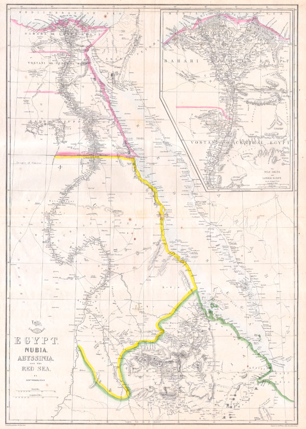
Egypt, Nubia, Abyssinia and the Red Sea.
1858 17 x 25 in (43.18 x 63.5 cm)
1858 17 x 25 in (43.18 x 63.5 cm)
Description
This hand colored map is a lithographic transfer, dating to 1858, by London cartographer Edward Weller. Depicts northeastern Africa from the city of Addis Ababa in Ethiopia, north along the Nile to Egypt and the Delta. Shows the Red Sea in full along with parts of Saudi Arabia.. Originally part of the Weekly Dispatch Atlas, whose September 19th, 1958 stamp still appears on the top left of the map.
Cartographer
Edward Weller (July 1, 1819 - 1884) was a cartographer and engraver based in London. Weller was a nephew of another well-known map publisher Sidney Hall (1788 - 1831), who gave him 50 Pounds to pay his apprenticeship fees. He engraved for many prominent mapmakers and was active enough in the community to be recommended for membership to the Royal Geographical Society in 1851 on the recommendation of John Arrowsmith, among others. He eventually inherited the Sidney Hall map business which led him to follow Arrowsmith as the unofficial geographer to the Royal Geographical Society. Weller was among the first map printers in London to embrace lithography. His best known work appears in Cassell's Weekly Dispatch Atlas, published in monthly segments for subscribers of the 'Weekly Dispatch' newspaper. This collection of maps eventually grew to include much of the known world. Published in various editions from 1855 through the early 1880s. Weller died in May of 1884, leaving behind a successful business and an unhappy widow. His son, Francis Sidney Weller (1849 - 1910), followed in his father's footsteps and continued the family map business. The atlas Mackenzie's Comprehensive Gazetteer of England and Wales was published in 1894 and bore F. S. Weller's signature on the maps. More by this mapmaker...
Condition
Very good condition.