
Weller, Edward

Edward Weller (July 1, 1819 - 1884) was a cartographer and engraver based in London. Weller was a nephew of another well-known map publisher Sidney Hall (1788 - 1831), who gave him 50 Pounds to pay his apprenticeship fees. He engraved for many prominent mapmakers and was active enough in the community to be recommended for membership to the Royal Geographical Society in 1851 on the recommendation of John Arrowsmith, among others. He eventually inherited the Sidney Hall map business which led him to follow Arrowsmith as the unofficial geographer to the Royal Geographical Society. Weller was among the first map printers in London to embrace lithography. His best known work appears in Cassell's Weekly Dispatch Atlas, published in monthly segments for subscribers of the 'Weekly Dispatch' newspaper. This collection of maps eventually grew to include much of the known world. Published in various editions from 1855 through the early 1880s. Weller died in May of 1884, leaving behind a successful business and an unhappy widow. His son, Francis Sidney Weller (1849 - 1910), followed in his father's footsteps and continued the family map business. The atlas Mackenzie's Comprehensive Gazetteer of England and Wales was published in 1894 and bore F. S. Weller's signature on the maps.
The first European expedition into the Tian Shan Mountains.
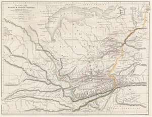
Map of Russian and Chinese Frontier Illustrating the Journey of Semenof to the Tian-Shan Mounts. and R. Jaxartes and Golubof's Issyk-kul Expedition.
$575.00
Acquire
- Digital Map Information
- Suitable for large format printing
- File Size: 12.88 MB
- File Type: ZIP / TIFF
- ICC color profile embedded
- Delivered instantly via download link
This is an 1861 John Murray map of Central Asia tracing Pyotr Semyonov's (1827 - 1914) first European ascent into the Tian Shan Mountains. The map depicts the region from Lake Balkash south to the Tian Shan Mountains, encompassing modern-day Kyrgyzstan, Kazakhstan, and western China - at the time considered one of the most remote and inaccessible parts of the world. (more details)
Landmark map of an Amazon tributary.
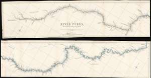
Map of the River Purûs, From Near its Source to its Mouth.
$300.00
Acquire
- Digital Map Information
- Suitable for large format printing
- File Size: 18.98 MB
- File Type: ZIP / TIFF
- ICC color profile embedded
- Delivered instantly via download link
This is landmark 1866 William Chandless map of the Purûs River in Brazil and Peri is he first accurate map of the river's 1,866-mile course. Chandless took measurements throughout his expedition, covering both the ascent and the descent of the river. He identifies tributaries, islands, and Indian villages, and includes a handful of comments concerning the river's depth and width. In the appendix to his article on the expedition, Chandless addresses the creation of the map:
This has been made from bearings and distances taken throughout the whole river, and from observations with sextant and artificial horizon (mercurial). Observations of latitude were taken at 79 points, and time observations for longitude by chronometer at about three-fourths of them. So far as was possible, time observations were repeated at the principal points on the down voyage, so as to be dependent on chronometer for a few days only.Even today the Purûs River basis is considered on of the most remote, biodiverse, and inaccessible parts of the Amazon Rainforest. In 2008, a previously unknown pre-Columbian civilization was discovered in the upper region of the river close to the Bolivian border. After much of the forest in the region was cleared for agricultural use, satellite pictures revealed the remains of large geometric earthworks. (more details)
First detailed map of the Juruá River, one of the longest tributaries of the Amazon.
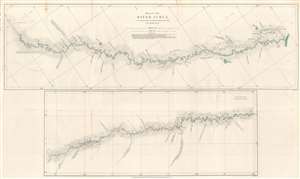
Map of the River Juruá.
$250.00
Acquire
- Digital Map Information
- Suitable for large format printing
- File Size: 13.33 MB
- File Type: ZIP / TIFF
- ICC color profile embedded
- Delivered instantly via download link
This is an 1869 William Chandless map of the Juruá River. The map divides the Juruá into two sections. The upper map illustrates the Juruá from its confluence with the Amazon to a point near Lake Ocoá. The lower map illustrates the upper portion of the river from Lake Ocoá to the point where the expedition reversed course. Small black crosses mark astronomical observations, and the dashed lines indicate the mouth of a lake or tributary. Chandless includes comments on the nature of the tributaries, and also notes the locations of the few tribal villages he encountered. (more details)
The early days of British Aden.
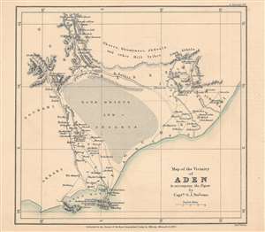
Map of the vicinity of Aden to accompany the paper by Captn. G. J. Stevens.
$350.00
Acquire
- Digital Map Information
- Suitable for large format printing
- File Size: 10.78 MB
- File Type: ZIP / TIFF
- ICC color profile embedded
- Delivered instantly via download link
This is an 1873 map of Aden, Yemen and its surroundings engraved by Edward Weller and published by the firm John Murray for the The Journal of the Royal Geographical Society. The map accompanied an article written by Captain G. J. Stevens of his travels through these lands. (more details)
The beginning of events leading to the Second Anglo-Afghan War.

Map of Eastern Persia to illustrate the Paper by Major General Sir F. J. Goldsmid.
$350.00
Acquire
- Digital Map Information
- Suitable for large format printing
- File Size: 6.04 MB
- File Type: ZIP / TIFF
- ICC color profile embedded
- Delivered instantly via download link
This is an 1873 John Murray map of eastern Persia, or modern-day south-central Iran. A thin red line highlights Sir Frederic John Goldsmid's route through the region from Bandar Abbas on the Strait of Hormuz north to Mash-had. Goldsmid was dispatched to this region in order to enforce a British-negotiated Selstan frontier boundary settlement, a move in the 'Great Game' intended to secure Persia and Afghanistan as buffer provinces between Russia and British India. (more details)
Great Game: Tsar's Acquisition of Transoxiana.
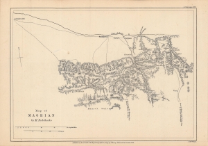
Notes on M. Fedchenko's Map of Maghian.
$250.00
Acquire
- Digital Map Information
- Suitable for large format printing
- File Size: 4.89 MB
- File Type: ZIP / TIFF
- ICC color profile embedded
- Delivered instantly via download link
This is an 1873 map of 'Maghian,' that is, the area that now comprises the westernmost portion of Sughd Province in Tajikistan, along the border with Uzbekistan. Based on a Russian map by Alexei Fedchenko, it was lithographed by Edward Weller and published by John Murray in the Journal of the Royal Geographical Society. (more details)
Pre-Japanese look at indigenous Taiwan.
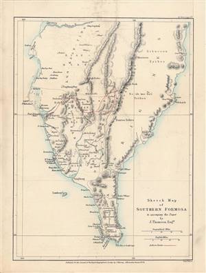
Sketch Map of Southern Formosa.
$650.00
Acquire
- Digital Map Information
- Suitable for large format printing
- File Size: 4.27 MB
- File Type: ZIP / TIFF
- ICC color profile embedded
- Delivered instantly via download link
This is a rare 1873 lithograph of the southern tip of Taiwan, published for the The Journal of the Royal Geographical Society. It encapsulates the geographical knowledge gained during an 1871 trip through southern Taiwan by the geographer and photographer John Thomson and his companion, the missionary James Laidlaw Maxwell. (more details)
'Most Desolate and Uninviting.' -Forrest
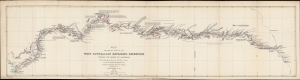
Map showing the route of the West Australian Exploring Expedition through the centre of Australia from Champion Bay on the west coast to the Overland Telegraph Line between Adelaide and Port Darwin.
$850.00
Acquire
- Digital Map Information
- Suitable for large format printing
- File Size: 136.62 MB
- File Type: ZIP / TIFF
- ICC color profile embedded
- Delivered instantly via download link
An 1875 map prepared by John Forrest, head of the Western Australia Exploring Expedition. It traces the progress and discoveries of the first extensive exploration of Western Australia's interior. (more details)
After the conquest of Khiva.
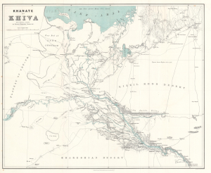
Khanate of Khiva after Russian sources.
$500.00
Acquire
- Digital Map Information
- Suitable for large format printing
- File Size: 24.08 MB
- File Type: ZIP / TIFF
- ICC color profile embedded
- Delivered instantly via download link
This is an 1875 Herbert William Wood map of the Khanate of Khiva in modern-day Uzbekistan - issued shortly after the 1873 Russian conquest of Khiva, a defining moment in the Great Game. (more details)
Traces the 1877 expedition of British Army officer William John Gill.
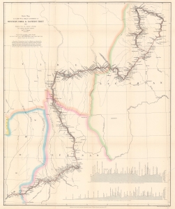
Route Map of Captain W. J. Gill's Journey in Western China and Eastern Tibet.
$850.00
Acquire
- Digital Map Information
- Suitable for large format printing
- File Size: 16.95 MB
- File Type: ZIP / TIFF
- ICC color profile embedded
- Delivered instantly via download link
This is a scarce and important 1878 William John Turner map of western China and eastern Tibet tracing Captain William John Gill's 1877 expedition through the region. (more details)
One of the first western maps of Xinjiang, China, illustrating a Great Game Era British trade mission.
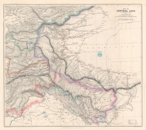
Map of Central Asia to accompany the Paper by Captain H. Trotter R.E., on the Geographical Results of Sir T.D. Forsyth's Mission to Kashgar, 1873 - 74.
$950.00
Acquire
- Digital Map Information
- Suitable for large format printing
- File Size: 24.76 MB
- File Type: ZIP / TIFF
- ICC color profile embedded
- Delivered instantly via download link
This is a 1878 William John Turner and Royal Geographical Society map of Xinjiang, China, that traces explorations of the 1873 - 1874 Forsyth Mission, making this one of the first detailed Western maps of the region. The map is a relic of the Great Game, a series of struggles between Britain and Russia to control Central Asia. (more details)
Surveying the interior of the Malay Peninsula.
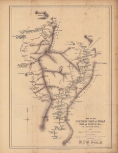
Map of the northern part of Perak (Malay Peninsula)...
$1,300.00
Acquire
- Digital Map Information
- Suitable for large format printing
- File Size: 12.31 MB
- File Type: ZIP / TIFF
- ICC color profile embedded
- Delivered instantly via download link
An early map of the northern part of the Perak Sultanate, now a state of Malaysia, prepared by pioneering British surveyor Dominic Daniel Daly for publication in the 1882 Proceedings of the Royal Geographical Society. It dates from soon after the establishment of a British residency in the sultanate, amid a tin mining boom that transformed the region's economy and society. (more details)
Expanding British influence in Malaya; early mention of Kuala Lumpur.
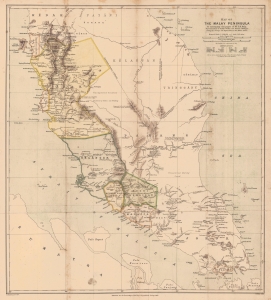
Map of the Malay Peninsula. To accompany the paper of Mr. D.D. Daly...
$1,100.00
Acquire
- Digital Map Information
- Suitable for large format printing
- File Size: 16.98 MB
- File Type: ZIP / TIFF
- ICC color profile embedded
- Delivered instantly via download link
An important map of the Malay Peninsula by Dominic Daniel Daly, lithographed by Edward Weller and published in 1882 in the Proceedings of the Royal Geographical Society. Daly's surveys of portions of the peninsula were the first scientific surveys conducted there. The map depicts the peninsula as British influence over the indigenous sultanates was expanding rapidly, aided by a boom in tin mining. (more details)
Botanical excursion through Central Asia.
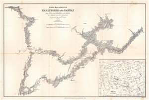
Survey Map of Route in Karateghin and Darwaz Made During the Expedition of Dr. Regel.
$375.00
Acquire
- Digital Map Information
- Suitable for large format printing
- File Size: 17.72 MB
- File Type: ZIP / TIFF
- ICC color profile embedded
- Delivered instantly via download link
This is an 1886 M. Kossiakof map of Turkestan in Central Asia. Red lines trace Kossiakof's route through the Rasht Valley (Karateghin) and Darvaz (Darwaz) regions with the 1881 Regel Expedition. The primarily botanically focused 1881 expedition was led by Johann Albert von Regel (1845 - 1909), a Swiss-Russian physician and botanist. Nonetheless, the Regel Expedition was one of the first European penetrations into the area. Kossiakof was a military topographer attached to the mission. He mapped the region, labeling cities, towns, and villages through which the group passed. Rivers are illustrated. In the lower right corner, an inset map of Asia and eastern Europe situates the depicted area in a continental manner. The map covers only the actual path followed, along with the observable surrounds, underscoring Kossiakof's integrity in illustrating only scientifically confirmed geography. (more details)
Connecting Burma and China by rail - bold but hopeless...
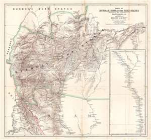
Parts of Burmah, Siam and the Shan States illustrating the explorations of Holt S. Hallett, C.E.
$400.00
Acquire
- Digital Map Information
- Suitable for large format printing
- File Size: 33.9 MB
- File Type: ZIP / TIFF
- ICC color profile embedded
- Delivered instantly via download link
This is an 1886 Henry Sharbau and H. A. Milne map of Burma (Myanmar) and Thailand. The map focuses on northern Thailand (Siam) and the railroad proposed by civil engineer Holt S. Hallett (1841 - 1911) and his associate Archibald Colquhoun (pronounced kuhl-HOON.) It was created to accompany a paper Hallett presented to the Royal Geographical Society. Red lines trace Hallett's explorations,
scouting and surveying the best railroad route. A dashed black and white line illustrated the proposed railway, running south from Kiang Hsen to the map's lower border. An inset along the right illustrates the route's continuation to Bangkok. (more details)
Britain's Bulwark.
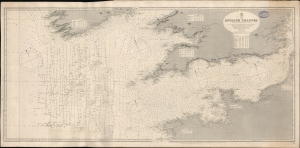
English Channel. [Admiralty Chart No.] 1598.
$600.00
Acquire
- Digital Map Information
- Suitable for large format printing
- File Size: 73.9 MB
- File Type: ZIP / TIFF
- ICC color profile embedded
- Delivered instantly via download link
A large-format 1897 nautical map or chart of the English Channel produced by the British Admiralty. It demonstrates both the notorious hazards of the channel for larger ships, as well as a greater understanding and cataloging of those same hazards in the late 19th century. (more details)
The first successful ascent of Aconcagua, the tallest mountain in America.
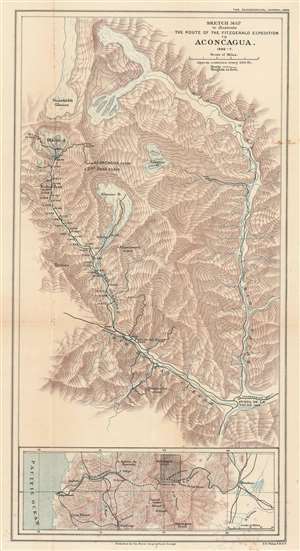
Sketch Map to illustrate the Route of the Fitzgerald Expedition to Aconcagua 1896 - 7.
$700.00
Acquire
- Digital Map Information
- Suitable for large format printing
- File Size: 14.7 MB
- File Type: ZIP / TIFF
- ICC color profile embedded
- Delivered instantly via download link
This is an 1898 Francis Sidney Weller map of This is an 1898 Francis Sidney Weller map of Mount Aconcagua, Mendoza Province, Argentina. The map depicts the region around Aconcagua, principally the Horcones Valley and the Vacas Valley. Black lines trace the 1896 – 1897 expedition financed and led by Edward Fitz Gerald (FitzGerald) that made the first successful ascent of Aconcagua. Aconcagua, labeled here in large block characters, is the tallest mountain outside Asia, as such it is also the tallest mountain in the Americas and in the Western and Southern Hemispheres. The region's topography is illustrated by hachure, and the area's glaciers and other major peaks are identified. An inset map along the bottom border situates Aconcagua in the larger region, placing it between Valparaiso, Chile and Mendoza, Argentina, where Fitz Gerald's team started their ascent. The proposed Trans-Andine Railway is illustrated here as well, with black lines detailing its progress through the mountains. (more details)
One of the most beautiful places on Earth.
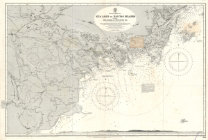
Kua Lakh to Kao Tao Islands Including The Delta of the Song Ka.
$500.00
Acquire
- Digital Map Information
- Suitable for large format printing
- File Size: 76.86 MB
- File Type: ZIP / TIFF
- ICC color profile embedded
- Delivered instantly via download link
This is a 1926 British Admiralty nautical chart or maritime map of northeastern Vietnam in the vicinity of Hanoi and Ha Long Bay. Today, this area is regarded as one of the most beautiful places on Earth. (more details)