1849 Greenleaf Map of Egypt
Egypt-greenleaf-1849$200.00

Title
Egypt.
1849 (undated) 13 x 10.75 in (33.02 x 27.305 cm) 1 : 1950000
1849 (undated) 13 x 10.75 in (33.02 x 27.305 cm) 1 : 1950000
Description
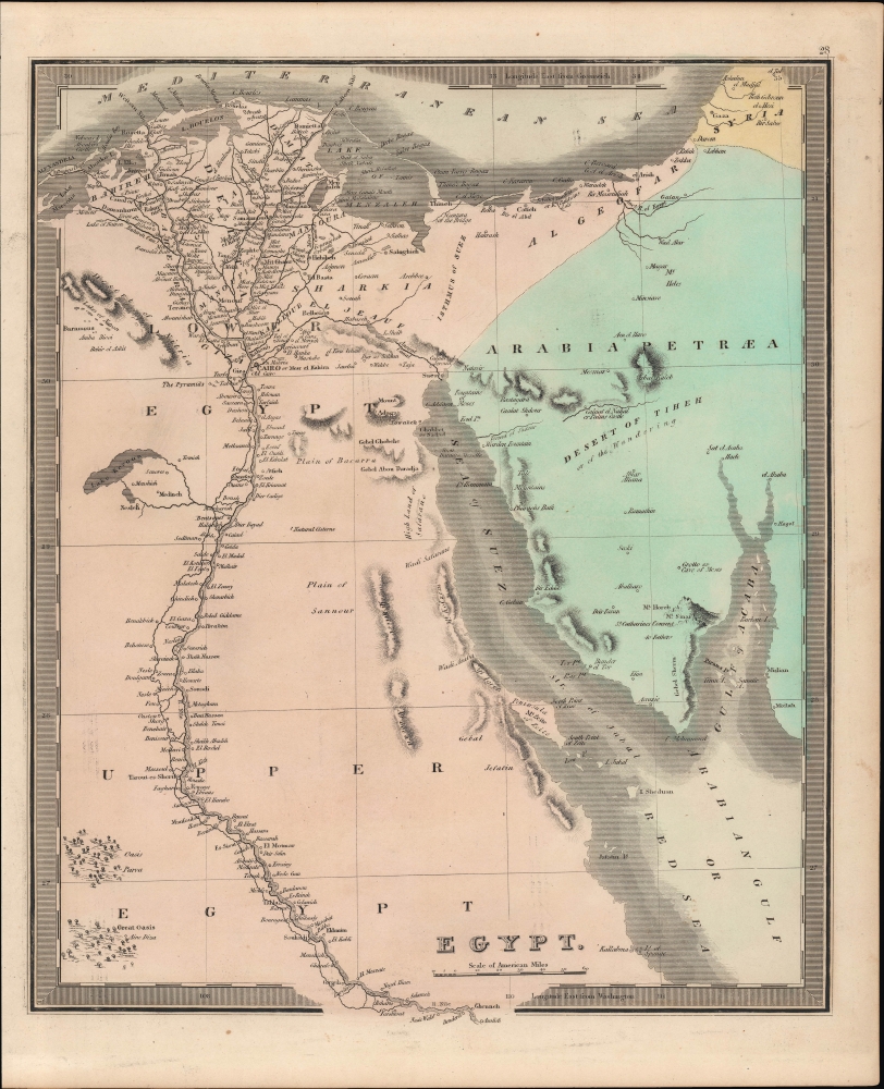
This is Jeremiah Greenleaf's 1849 hand-colored map of Egypt, focusing on the Nile River Delta and the Sinai Peninsula. It displays the region as it was undergoing significant turmoil and political change, as the skilled general Muhammed Ali first re-imposed then broke free from Ottoman control to establish his own independent dynasty.
A Closer Look
The map depicts Egypt, centered on the Nile River from its delta on the Mediterranean, south as far as Asalieh. Greenleaf notes cities and villages along the river as well as beautifully rendered topography. Ancient ruins such as 'the Pyramids' outside Giza and Pompey's Pillar at Alexandria are labeled, as are other sites recorded in antiquity, such as the Fountains of Moses and the Pharoh's Bath on the Gulf of Suez. Aside from the Nile region, settlements, and geographic features are recorded more sparsely, reflecting the desert environment, with greater detail along coastlines.Historical Context
This map was prepared in the declining days of the Ottoman Empire. In Egypt, following the expulsion of the Napoleonic forces by the Ottoman Mamluk Turks, Muhammad Ali, the Ottoman viceroy of Egypt, established a dynasty that would rule Egypt until the Egyptian Revolution of 1952, albeit under the indirect control of Britain for most of that time. Between 1820 and 1833, Ali annexed northern Sudan, Syria, and parts of Arabia into his realm. After the conquest of Palestine by Muhammad Ali's Egypt in 1832, British intervention returned control of Palestine to the Ottoman rulers in 1840.Publication History and Census
This map was published by Jeremiah Greenleaf in the scarce 1849 (last) edition of his New Universal Atlas. It is based on David Burr's 1834 original, which was published in the latter's atlas of the same name, before being inherited and updated by Greenleaf, who published it in several editions in the 1840s.CartographerS
Jeremiah Greenleaf (1791 - 1864) is a little known but highly admired American cartographer of the early 19th century. He published from roughly 1830 to 1850. His most important work is A New Universal Atlas; Comprising of all the Principal Empires, Kingdoms, and States Throughout the World and Forming a distinct Atlas of the United States, published in several editions in the 1840s. Many of his maps are reformatted versions of his contemporary David Burr's much admired cartographic works. Greenleaf's maps are extremely rare and admired for their stunningly vivid pastel color washes. More by this mapmaker...
David Hugh Burr (August 18, 1803 - December 25, 1875) of one of the first and most important truly American cartographers and map publishers. Burr was born in Bridgeport Connecticut in August of 1803. In 1822 Burr moved to Kingsboro, New York to study law. A year and a half later he was admitted to the New York Bar association. Burr must have questioned his choice of careers because shortly after being admitted to the Bar, he joined the New York State Militia. Though largely untrained in the art of surveying, Burr was assigned to work under Surveyor General of New York, Simeon De Witt, to survey several New York Roadways. Seeing a window of opportunity, Burr was able to negotiate with the governor of New York at the time, De Witt Clinton, to obtain copies of other New York survey work in order to compile a map and Atlas of the state of New York. Recognizing the need for quality survey work of its territory, the government of New York heartily endorsed and financed Burr's efforts. The resulting 1829 Atlas of the State of New York was the second atlas of an individual U.S. state and one of the most important state atlases ever produced. Burr went on to issue other maps both of New York and of the United States in general. In cooperation with publishing firm of Illman & Pillbrow, he produced an important New Universal Atlas and, with J.H. Colton, several very important maps of New York City. In recognition of this work, Burr was appointed both "Topographer to the Post office" and "Geographer to the House of Representatives of the United States". Later, in 1855, Burr was assigned to the newly created position of Surveyor General to the State of Utah. Burr retired from the position and from cartographic work in general in 1857 when light of some of his financial misdeeds and frauds came to light. He was accused of submitting false expense reports and underpaying employees, among other indiscretions. Learn More...
Source
Greenleaf, J., New Universal Atlas, (Brattleboro, Vermont: Greenleaf) 1849.
Condition
Very good.
References
Rumsey 15176.032.