This item has been sold, but you can get on the Waitlist to be notified if another example becomes available.
1854-1866 Linant de Bellefonds Set of Maps of the Nile River Valley and the Suez Canal
Egypt-linant-1866$3,000.00


Title
Carte Hydrographique de la Basse Égypte/ Carte Hydrographique de la Moyenne Égypte/Carte Hydrographique de la Partie Septentrionale de la Haute Egypte/ Carte Hydrographique de la Partie Méridionale de la Haute Egypte.
1866 (dated) 31.75 x 51.25 in (80.645 x 130.175 cm) 1 : 250000
1866 (dated) 31.75 x 51.25 in (80.645 x 130.175 cm) 1 : 250000
Description
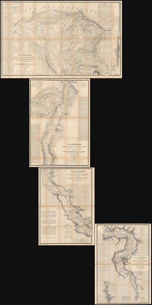
This is a set of four large, superbly detailed maps of Egypt by Linant de Bellefonds, detailing the course of the River Nile and the prospective routes of the Suez Canal. The four maps are on a uniform scale and were sold a group by Paris mapseller Lanée, to American congregationalist preacher and professor Roswell Dwight Hitchcock, probably in 1869 in preparation for that avid traveler's 1870 visit to Egypt. These were easily the most detailed maps to cover the Egyptian Nile available at that time, and their rich detail of ancient and reference to Biblical monuments would have been compelling. Taken together, the maps illuminate the Nile continuously from the Mediterranean Sea to the cataracts upstream of Aswan.
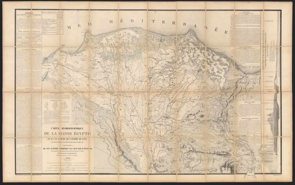
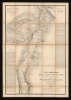
In the midst of the desert of the Isthmus of Suez - an area including caravan trails on the 1822 map, and little more - Linant's map includes notes regarding canal traces described by the local Arabs as 'the Pharaoh's Canal.' Linant specifically characterizes these as 'Vestiges du Canal des deux Mers'. He also noted the presence of 'Bancs de Coquillages,' (shell beds), suggesting that a waterway existed at one time connecting the Mediterranean and the Red Sea. Linant's commentary includes the key idea that the level of the two seas was not measurably different, directly contradicting the belief that prohibitively costly and time-consuming lock systems would be required for such a waterway. The 1855 Kaeppelin edition of this map included for the first time a proposed course for the Suez Canal; the profile of the canal route at the right-hand border of the map was also added at this time. In addition, the 1855 printing included significant updating throughout showing telegraph lines, a railroad connecting Alexandria and Cairo, and new developments (particularly the new neighborhood of Abbasia, northeast of Cairo). It also contained several edits to the accompanying text at the borders, and updated statistical tables.
As early as 1856, but probably in the vicinity of 1866, the printing firm Lemercier produced a variant of Kaeppelin's edition, with which the present example corresponds. This, while distinguishable, introduced no changes in content. In 1882, Lemercier produced the final iteration of the map, this time edited to show the course of the completed Suez Canal.
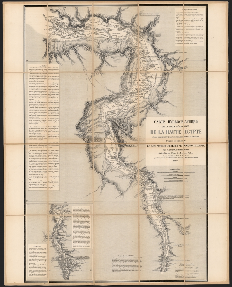
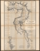
These two maps were initially printed by Kaeppelin in 1855 and 1854 respectively. Lemercier editions of both exist; that edition of the southernmost map is dated 1866; ours conforms to this example. The northern map in this set is an example of the 1855 Kaeppelin issue.
Linant de Bellefonds in Egypt
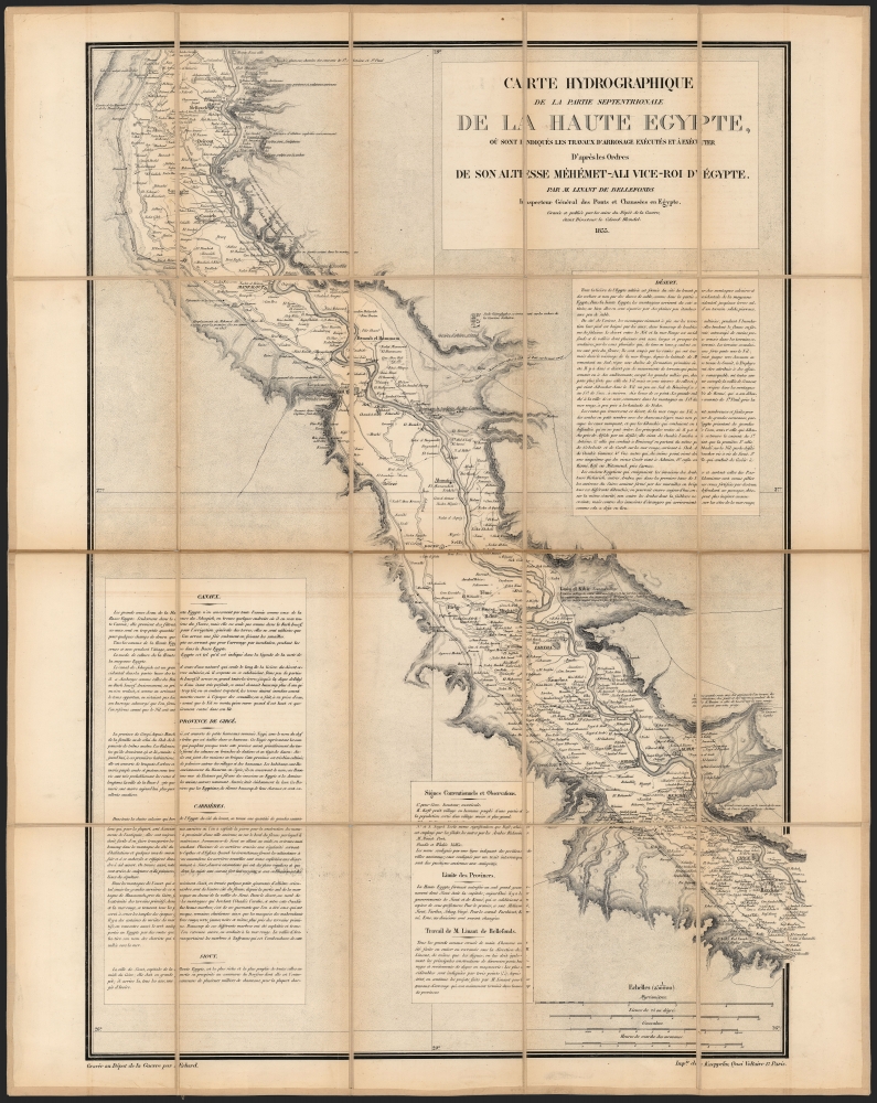
Linant's experience of Egypt began when he was still a cadet aboard the frigate Cléopâtre on a mission to the Levant, which ended at Cairo. Linant stayed on, setting out on a series of explorations that characterized a large part of his extraordinary adult life. Throughout his travels, he noted archaeological traces of hydrology: ancient canals, in the Sinai and Suez. He would later write that his 1827 and 1828 visits to the Isthmus of Suez inspired his first studies of a project to connect the Mediterranean and Red Seas, and he dedicated himself to engineering thereafter. As a result, he rose to chief engineer of the public works of Upper Egypt in 1831. In this position, he was responsible for modernizing Egypt's irrigation canals. In the course of these activities, he drew a series of hydrographic maps of Egypt at a uniform scale of 1:250000. Those focusing on the Middle and Upper Nile mostly pertained to Egypt's irrigation, and provide the most detailed and reliable overview of the dike system available at that time. The map of the Lower Nile, embracing as it does the Nile Delta and the Isthmus of Suez, is of primary importance for Linant's quest to connect the Mediterranean and the Red Sea.The Suez Canal
Linant's first official proposals for the construction of a canal through the Isthmus of Suez were submitted in 1841, and by 1844 he provided ambassador Ferdinand de Lesseps with complete plans for the canal. Lesseps obtained the canal concession from viceroy Muhammad Sa'id on behalf of the Compagnie Universelle du Canal Maritime de Suez, of which Linant was chief engineer. Between Linant's submission to Lesseps and its acceptance by the viceroy, there was published in 1847 for the Dépôt Général de la Guerre by Paris lithographer Kaeppelin the large, superbly-detailed Carte Hydrographique de la Basse Egypte et d'une partie de l'Isthme de Suez. The publication of that map during the promotion of the canal project suggests that it may have been instrumental in Lesseps' efforts to build support.Updating the Hydrography of Egypt
These maps were based on the maps of the corresponding areas to be found in the 1822 Description de l'Egypte, the work cataloging the efforts of Napoleon's Commission des sciences et arts d'Egypte, whose archaeologists, cartographers, and engineers swarmed northern Egypt in the first part of the 19th century. These tended to focus on antiquities, but among included Napoleon's vestigial canal leading north from Suez. (The discovery of this canal, made during Napoleon's 1798 campaign in Egypt and Syria, spurred the French to form the Commission in the first place.) While not reinventing material when the Commission's maps would serve, Linant updated the maps thoroughly within his expertise. His edits included new and proposed irrigation canals, with extensive corrections and notations regarding dried bodies of water throughout.The Lower Nile
For Linant, this was the most important of his four maps: not only did it focus on the Nile Delta from Cairo to the Mediterranean, but it also encompassed the Isthmus of Suez, where he believed a canal connecting the Red Sea and the Mediterranean was most practicable. Certainly, Linant completed this map before any others: we see no evidence that his maps of the Middle and Upper Nile were produced any earlier than 1854, while the first edition of his map of the Lower Nile, lithographed by Kaeppelin, is dated 1847.In the midst of the desert of the Isthmus of Suez - an area including caravan trails on the 1822 map, and little more - Linant's map includes notes regarding canal traces described by the local Arabs as 'the Pharaoh's Canal.' Linant specifically characterizes these as 'Vestiges du Canal des deux Mers'. He also noted the presence of 'Bancs de Coquillages,' (shell beds), suggesting that a waterway existed at one time connecting the Mediterranean and the Red Sea. Linant's commentary includes the key idea that the level of the two seas was not measurably different, directly contradicting the belief that prohibitively costly and time-consuming lock systems would be required for such a waterway. The 1855 Kaeppelin edition of this map included for the first time a proposed course for the Suez Canal; the profile of the canal route at the right-hand border of the map was also added at this time. In addition, the 1855 printing included significant updating throughout showing telegraph lines, a railroad connecting Alexandria and Cairo, and new developments (particularly the new neighborhood of Abbasia, northeast of Cairo). It also contained several edits to the accompanying text at the borders, and updated statistical tables.
As early as 1856, but probably in the vicinity of 1866, the printing firm Lemercier produced a variant of Kaeppelin's edition, with which the present example corresponds. This, while distinguishable, introduced no changes in content. In 1882, Lemercier produced the final iteration of the map, this time edited to show the course of the completed Suez Canal.
Middle Egypt
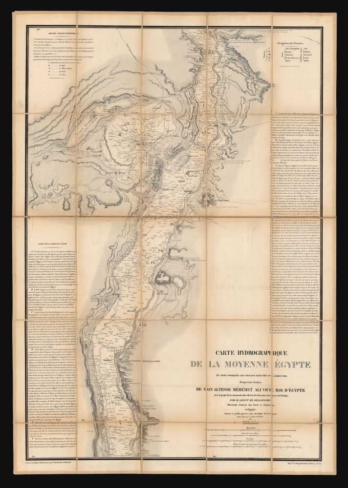
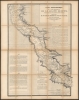
In contrast to the convoluted print history of the map of the Lower Nile, Carte Hydrographique De La Moyenne Égypt, was produced in a single, 1854 Kaeppelin edition. It focuses on the course of the Nile, from the vicinity of Saqiyat Moussa, north to just short of Giza. It includes the Faiyum Oasis, and notes many archaeological sites. As elsewhere, Linant's focus is on irrigation and the control of the reguar flooding of the Nile. The dikes he proposed are mainly intended for the maintenance of navigability and water levels further downstream. These works a proposed Grand Canal, which appears along the west bank of the Nile on this and the two maps of Upper Egypt.Upper Egypt
Linant's map of Upper Egypt is broken into two sections, north and south. The north part covers the Nile Valley from Bardis in the south to Qalandul and Mallawi in the north; the south spans from the vicinity of Farshut in the north to Gebel el-Silsila and an inset details the final portion culminating in the cataracts of Aswan.Monuments and proposed Works
The map's detail at 'Gebel and Cilicy' (Gebel el-Silsila) includes both a dam across the river and also the upstream portions of the Grand Canal (never constructed) running the west bank of the Nile from Gebel to the Bahr Jousef, at Faiyum. The site of Gebel el-Silsila was important going back to the Pharaonic Era. It was a crucial sandstone quarry as late as the Greco-Roman Period, and much of its stone can be found at Luxor. Linant seemed to think it a suitable location for a dam, perhaps due to the uniformity of the stony landscape; nevertheless, neither that dam nor the canal it was meant to feed were constructed.These two maps were initially printed by Kaeppelin in 1855 and 1854 respectively. Lemercier editions of both exist; that edition of the southernmost map is dated 1866; ours conforms to this example. The northern map in this set is an example of the 1855 Kaeppelin issue.
Provenance
Despite these maps being of different editions, they were sold together as a set in Paris, likely in 1869. The buyer's signature appears on the seller's labels on each map: Roswell Dwight Hitchcock (1817 - 1887). Hitchcock was a congregationalist minister, and professor at Bowdoin and later at the Union Theological Seminary in New York. His ministry took him to Germany in the 1840s. Afterwards, he visited Italy and Greece in 1866; and in 1869 and 1870 he traveled to Egypt and Palestine. He was appointed president of the American Palestine Exploration Society in 1871, and vice-president of the American Geographical Society in 1880. Whether he acquired these en route to Egypt, or on his way back to America, Hitchcock's dual enthusiasms for travel and geography came together in the acquisition of these maps.Publication History and Census
All four of these maps are scarce. We see a handful of examples of the Lemercier edition of Carte hydrographique de la Basse Égypte listed in OCLC with conjectural dates ranging from 1856 to 1868. We suspect a date of 1866, consistent with the Lemercier editions of the other maps in the set. Institutional collections list the Kaeppelin Moyenne Égypte in about ten copies, the Kaeppelin Partie Septentrionale de la Haute Egypte shows nine, and seven of the 1866 Lemercier Partie Méridionale de la Haute Egypte.CartographerS
Louis Maurice Adolphe Linant de Bellefonds (November 23, 1799 - July 9, 1883) was a French engineer and explorer. He was a principal engineer of the Suez Canal, and is listed as a founder of the Suez Canal Company. Born in the port city of Lorient, Linant was educated with an emphasis on mathematics, drawing and painting. His father Antoine-Marie, a naval officer, had charted the coastal waters of Newfoundland in 1814 and it is thought that Bellefonds assisted his father. He joined the navy as a cadet, and served aboard the frigate Cléopâtre, engaged on a mission to Greece, Syria, Palestine, and Egypt. On this voyage, he made drawings and relief maps. One of the expedition's artists died on the voyage, and Linant was on hand to be commissioned as his replacement. Thus, the expedition saw Linant drawing ancient sites and ruins in Athens, Constantinople, Ephesus, Akka and Jerusalem.
The voyage continued from Jaffa to Damietta by camel, then up the Nile to Cairo. Upon arrival, Linant chose not to return to France but to remain in Egypt. This was only the first in a wild array of African and Middle Eastern explorations that would occupy him until 1830, and which he would describe later in his Mémoires. During the course of his expeditions, he studied ancient canal works; his exploration of the Suez in 1827 and 1828 led him to consider the possibilities of a canal connecting the Mediterranean and the Red Sea. According to his own account, he then spent a year in the study of engineering in order 'to acquire what I lacked in scientific understanding to take up service with the Egyptian government in the character of an engineer'. Indeed, upon his return to Cairo he would be named chief engineer of the public works of Upper Egypt. While engaged in what would prove a long career modernizing Egypt's system of irrigation canals and Nile levees, he did not neglect his notion of a communication between the Mediterranean and the Red Seas. He submitted an early plan to the Compagnie Péninsulaire et Orientale in 1841, and in 1844, a set of complete plans. When in 1854 the Compagnie universelle du canal maritime de Suez gained the concession for the canal, Linant was named chief engineer. He retired in 1869 to write his memoir, the best and most flamboyant account of his own deeds.
More by this mapmaker...
Kaeppelin et Cie (fl. c. 1839 - 1860) was a Parisian publisher of prints and maps based at 15 Quai Voltaire. It appears to have developed an expertise in works dealing with the Anglophone world, including North America and Australia. Learn More...
Rose-Joseph Lemercier (June 29, 1803 - 1887) was a French photographer, lithographer, and printer. One of the most important Parisian lithographers of the 19th century, Lemercier was born in Paris into a family of seventeen children. His father was a basket maker, and he even began working as a basket maker at the age of fifteen, but Lemercier was drawn to lithography and printing and soon entered into an apprenticeship with Langlumé, where he worked from 1822 until 1825. After working for a handful of other printers, Lemercier started his own firm in 1828 at 2, rue Pierre Sarrazin with only one printing press. He subsequently moved a few more times before arriving at 57, rue de Seine, where he founded the printing firm Lemercier and Company. He created the firm Lemercier, Bénard and Company in 1837 with Jean François Bénard. Lemercier bought out Bénard's share in the firm in 1843 and, since his two sons died at a young age, he decided to bring his nephew Alfred into the business beginning in 1862, who would progressively take on more and more responsibility in running the firm. Between 1850 and 1870, Lemercier's firm was the largest lithographic company in Paris. The firm began to decline in prestige in the early 1870s, and, after Lemercier's death in 1887, its descent only quickened. It is unclear when the firm closed, but Alfred directed the firm until his death in 1901. Learn More...
Condition
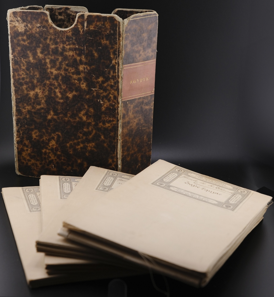
Very good. Four lithograph maps dissected and mounted on linen for folding, by publisher: Lower Egypt 31.75 x 51.25 inches; Middle Egypt 37.25 x 25.25 inches; Upper Egypt (north part) 33 x 23.5 inches; Upper Egypt (south part) 34.25 x 22.75 inches. Folds to fit slipcase, 9 x 6 x 2.5 inches. Some separations in linen, else excellent Original slipcase in marbled papers.
References
OCLC 841569819, 47115124, 841569824, 53798712.