1588 Livio and Giulio Sanuto Map of Egypt, Libya and the Lower Nile
Egypt-sanuto-1588$2,500.00

Title
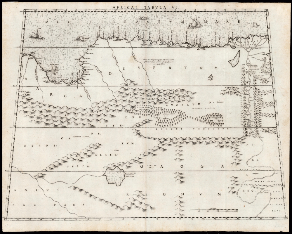
Africae Tabula VI.
1588 (undated) 15.5 x 20.5 in (39.37 x 52.07 cm) 1 : 5321000
1588 (undated) 15.5 x 20.5 in (39.37 x 52.07 cm) 1 : 5321000
Description
This elegant map of Egypt, focusing on the Lower Nile and Eastern Mediterranean coast was printed in a single edition in 1588 for Livio and Giulio Sanuto's twelve-sheet 'atlas' of Africa. Of the 16th century maps focusing north Africa, Sanuto is unique. His depiction of the continent differed sharply from any contemporaneous map, the result of his thorough reconsideration of African geography in the light of both conventional and newly available sources - marking it as a unique and underappreciated masterpiece of geographical thought.
There are features along the Nile unique to the present work, for example the eremitic cells of Saint Anthony and shire of Saint Paul the Anchorite. These are depicted on no other prior map we have seen. These saints were of particular importance in Coptic Christianity, and their holy sites may have been included in the reports of missions to Abyssinia (such as that of Francisco Álvares, which was consulted extensively by Sanuto for his maps of the Upper Nile.) The consistency of the geographical information on this map with Sanuto's map of Abyssinia - for example, in the meandering of the Nile upriver from Aswan, and into 'Barnagassi Regnum' - suggests that Álvares' information might have also impacted the present work.
Sanuto's treatment of the deserts west of the Nile is sharply different from either Ptolemy, or Gastaldi. Some features - notably the lakes of Gaoga and Fons Solis, do survive from those sources. But the positioning of mountains, cities, and even forests are here unique. The forests depicted in the regions of Berdoa - southeastern Libya - appear on no other map. Further south, the large Gaoga Lacus is depicted much as it is on earlier maps - except that here, it is declared to be the primary source of the River Canagar (Senegal River). While this itself represents a gross error, it is a different gross error than other mapmakers of the 17th century, who conflated the Senegal with the Niger.
We do not know the source of Sanuto's information on the Arab denizens of the Egyptian desert, but the sentiments of the map's comment - 'Arabes hoc in deserto degertes miserrime vivunt sunt vero proditores omnium totius fere terrarum orbis sclerosissimi.' ('the most hardened traitors of almost the entire world') - are such that one wonders who Sanuto's source on these Arabs might have been, and why their opinions were so negative.
Ancient Roots, Modern Fertilizer
The Ptolemaic map focusing on this area - 'Tertia Africae Tabula' as it was titled in the 1478 Rome Ptolemy - figured in at least part of Sanuto's geographical calculus. A comparison of the linear, schematic formulation of the mountains embanking the lower Nile and the ranges depicted striking towards the Red Sea between 23° and 27° latitude is enough to draw the conclusion that Sanuto consulted Ptolemy. Even so, the placenames along the Nile are not, for the most part, Ptolemaic.There are features along the Nile unique to the present work, for example the eremitic cells of Saint Anthony and shire of Saint Paul the Anchorite. These are depicted on no other prior map we have seen. These saints were of particular importance in Coptic Christianity, and their holy sites may have been included in the reports of missions to Abyssinia (such as that of Francisco Álvares, which was consulted extensively by Sanuto for his maps of the Upper Nile.) The consistency of the geographical information on this map with Sanuto's map of Abyssinia - for example, in the meandering of the Nile upriver from Aswan, and into 'Barnagassi Regnum' - suggests that Álvares' information might have also impacted the present work.
Sanuto's treatment of the deserts west of the Nile is sharply different from either Ptolemy, or Gastaldi. Some features - notably the lakes of Gaoga and Fons Solis, do survive from those sources. But the positioning of mountains, cities, and even forests are here unique. The forests depicted in the regions of Berdoa - southeastern Libya - appear on no other map. Further south, the large Gaoga Lacus is depicted much as it is on earlier maps - except that here, it is declared to be the primary source of the River Canagar (Senegal River). While this itself represents a gross error, it is a different gross error than other mapmakers of the 17th century, who conflated the Senegal with the Niger.
We do not know the source of Sanuto's information on the Arab denizens of the Egyptian desert, but the sentiments of the map's comment - 'Arabes hoc in deserto degertes miserrime vivunt sunt vero proditores omnium totius fere terrarum orbis sclerosissimi.' ('the most hardened traitors of almost the entire world') - are such that one wonders who Sanuto's source on these Arabs might have been, and why their opinions were so negative.
A Bright Light, Dimmed
As published, Sanuto's work was the first such book dedicated solely to Africa. This was not the author's intent, as the work was but one volume of a 12-volume global geography. If Sanuto were to have applied the same fresh thought to other regions that he applied to Africa, the result would certainly have been an atlas to eclipse that of Ortelius. As it happened, Livio died in 1576 before producing the other volumes, likely a victim of the plague. The completed volume - the set of Africa maps - was published posthumously in 1588, in a single edition. Thus, despite the detail and beauty of Sanuto's Africa maps, they achieved scant recognition. Dutch Golden Age mapmakers instead copied Ortelius's less refined mapping. Improved maps of the African interior did not appear until the 1670s and 80s, with the work of Du Val, Ludolf, and Coronelli. Of Sanuto's work, Bifolco and Ronca offer high praise:...The description of Africa is the best of the sixteenth century and the maps represent a happy synthesis of all the elements then available; hence it is legitimate to conclude that if Sanuto had succeeded in completing the entire work, we would have in it one of the greatest monuments of geography in the period of the Renaissance.
Publication History and Census
This map was composed by Livio Sanuto, and engraved by his brother Giulio for inclusion in their Geografia di M Livio Sanuto Distinta in XII Libri, of which only the Africa volume was published. It is not known when exactly the plates for the Geografia were engraved, but it is thought that Livio prepared the text for the work between 1561 and 1575. Livio died in 1576. The work was published posthumously in 1588 by Damiano Zenaro. We see only one example of this separate map in OCLC, cataloged by the Biblioteca Nacional de España. The complete atlas appears to be reasonably well represented in institutional collections.CartographerS
Livio Sanuto (1520 – 1576) was a Venetian cartographer and scientific instrument maker produced, with his engraver brother, Giulio (fl. 1540-1588) – an array of some of the most important geographical works produced in Venice during the second half of the sixteenth century. These included a 27-inch globe and the 1588 12-sheet atlas, Geografia della Africa. Among Livio and Giulio's works were some, if not all of the maps prepared for Ruscelli's 1561 Ptolemy. More by this mapmaker...
Giulio Sanuto (fl. 1540 – 1580) was a Venetian engraver. He was born the illegitimate son of Cavaliere Francesco di Angelo Sanuto; With his brother, the cartographer and scientific instrument maker Livio Sanuto (1520 – 1576) he produced an array of some of the most important geographical works produced in Venice during the second half of the sixteenth century. These included a 27-inch globe and the 1588 12-sheet atlas, Geografia della Africa. Giulio's career is singluar among Venice's engraves in that it appears to have been equally based on artistic, figurative work as well as his cartographic works. Giulio is more broadly known for a small but sought-after selection of decorative engravings; no more than twelve of these can be attributed confidently to him, including the monumental Apollo and Marsyas, measuring over 1.30 meters wide. Whilst Sanuto's engravings were generally based upon the designs of other artists, his work was both ambitious and grand, and he often signed these works. Learn More...
Source
Sanuto, L., Geografia di M Livio Sanuto Distinta in XII Libri, (Venice: Zenaro) 1588.
Condition
Very good; small areas of virtually invisible scuffing and worming.
References
Not in Afriterra. OCLC 796358674. Norwich, O. Maps of Africa cf 304. Bifolco, S. / Ronca, F. Cartografia e Topografia Italiana del XVI Secolo. pp. 2525-6.