
Sanuto, Giulio

Giulio Sanuto (fl. 1540 – 1580) was a Venetian engraver. He was born the illegitimate son of Cavaliere Francesco di Angelo Sanuto; With his brother, the cartographer and scientific instrument maker Livio Sanuto (1520 – 1576) he produced an array of some of the most important geographical works produced in Venice during the second half of the sixteenth century. These included a 27-inch globe and the 1588 12-sheet atlas, Geografia della Africa. Giulio's career is singluar among Venice's engraves in that it appears to have been equally based on artistic, figurative work as well as his cartographic works. Giulio is more broadly known for a small but sought-after selection of decorative engravings; no more than twelve of these can be attributed confidently to him, including the monumental Apollo and Marsyas, measuring over 1.30 meters wide. Whilst Sanuto's engravings were generally based upon the designs of other artists, his work was both ambitious and grand, and he often signed these works.
One of the Earliest Modern Maps of the Holy Land and Cyprus.
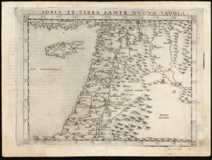
Soria et Terra Santa Nuova Tavola.
$650.00
Acquire
- Digital Map Information
- Suitable for large format printing
- Full resolution TIFF file
- ICC color profile embedded
- Delivered instantly via download link
This is a handsome example of Girolamo Ruscelli's 1561 / 1574 map of the Holy Land and Cyprus. It is an enlarged, more finely-engraved iteration of Giocomo Gastaldi's 1548 Soria e Terra Sancta nova tabula. While Tibbetts avers that the Ruscelli contains fewer place names than its Gastaldi source, he is incorrect: Ruscelli's map preserves all the data of the Gastaldi, but between the increased size of the plate and the clear, legible, and well-spaced engraving of the newer map, its data is presented without the crowding evident on the 1548 map. The skill evident in this work can be credited to the engraver Giulio Sanuto, one of the few Venetian engravers whose career was not isolated either to map engraving or to figurative artistic works, but consisted of both over a career of more than forty years. (more details)
One of the earliest Acquirable Post-Magellan Maps of Southeast Asia.
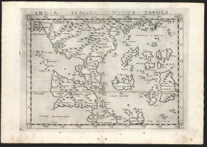
India Tercera Nuova Tavola.
$450.00
Acquire
- Digital Map Information
- Suitable for large format printing
- Full resolution TIFF file
- ICC color profile embedded
- Delivered instantly via download link
This is Girolamo Ruscelli's 1561 / 1574 map of the East Indies and Southeast Asia, considered to be among the earliest maps of Southeast Asia. Although based on Giacomo Gastaldi's 1548 map of the same title, it is roughly twice the size and better engraved. (more details)
One of the Earliest Modern Maps of Egypt.
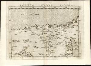
Egitto Nuova Tavola.
$325.00
Acquire
- Digital Map Information
- Suitable for large format printing
- Full resolution TIFF file
- ICC color profile embedded
- Delivered instantly via download link
This is Girolamo Ruscelli's 1561 map of Egypt. It is the second modern map of the Lower Nile, predated only by the 1548 Gastaldi map, upon which it is based. It is among the earliest acquirable maps to show the Nile Delta with contemporaneous information; it is also one of the first printed maps to depict the Egyptian Pyramids. (more details)
One of the Earliest Modern Maps of Italy.
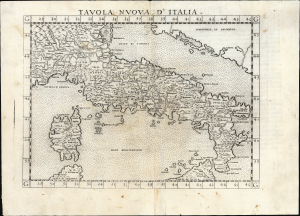
Tavola Nuova d' Italia.
$500.00
Acquire
- Digital Map Information
- Suitable for large format printing
- Full resolution TIFF file
- ICC color profile embedded
- Delivered instantly via download link
An influential 1561 map of Italy by Girolamo Ruscelli, based upon Giacomo Gastaldi's groundbreaking cartography and representing one of the defining maps of Renaissance Italy. Engraved by Giulio Sanuto for Ruscelli's edition of Ptolemy, the map greatly enlarged and refined Gastaldi's seminal 1548 map. From the Alps and Venice to Sicily, it presents Italy with a wealth of cities, mountains, rivers, and coastal detail, enlivened by a dramatically erupting Mount Etna and a miniature view of Venice. Gastaldi's geography, disseminated through Ruscelli's widely read atlas, remained the dominant cartographic representation of Italy until Giovanni Antonio Magini's 1608 map. (more details)
Among the Earliest Acquirable Contemporary Maps of Russia.
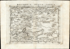
Moschovia Nuova Tavola.
$750.00
Acquire
- Digital Map Information
- Suitable for large format printing
- Full resolution TIFF file
- ICC color profile embedded
- Delivered instantly via download link
This is the 1561 first Ruscelli edition of Giacomo Gastaldi's map of Muscovy, one of the earliest acquirable modern maps of Russia. It is among the earliest obtainable maps to include Paolo Giovio's geography from the Muscovite Embassy. (more details)
Among the Earliest Acquirable Contemporary Maps of the Baltic Coast.
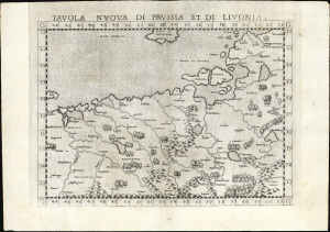
Tavola nuova di Prussia et di Livonia.
$650.00
Acquire
- Digital Map Information
- Suitable for large format printing
- Full resolution TIFF file
- ICC color profile embedded
- Delivered instantly via download link
This is the 1561 first Ruscelli edition of Giacomo Gastaldi's map of the Baltic Coast of Prussia and Livonia, now the coastline of Poland, Lithuania, Latvia, and Estonia. It is among the earliest detailed maps of this part of the world based on contemporary geographical knowledge, particularly with respect to the Gulf of Riga. (more details)
One of the Earliest Maps of Scandinavia, Greenland and Ultima Thule.
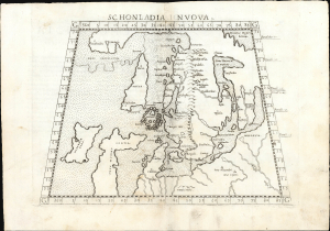
Schonlandia Nuova.
$1,000.00
Acquire
- Digital Map Information
- Suitable for large format printing
- Full resolution TIFF file
- ICC color profile embedded
- Delivered instantly via download link
This is a handsome example of Girolamo Ruscelli's 1561 map of Scandinavia, after Gastaldi. It is among the earliest generally acquirable modern maps of the northern parts of the world, capturing a period when geographers were struggling to integrate new geographical information with heretofore authoritative classical knowledge. Ruscelli's map is an expanded, more clearly-engraved and legible iteration of Gastaldi's 1548 Schonlandia Nova. (more details)
Roman-Era Egypt, as drafted by a Native Son.
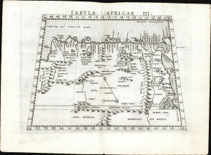
Tabula Africae III.
$600.00
Acquire
- Digital Map Information
- Suitable for large format printing
- Full resolution TIFF file
- ICC color profile embedded
- Delivered instantly via download link
This is a handsome example, in its first edition, of Girolamo Ruscelli's 1561 map of Libya and Egypt, extending to the Red Sea, based on the 2nd-century knowledge of Claudius Ptolemy. It represents the first mapping of the region based on information from someone who lived there. (more details)
First Edition of the Earliest Acquirable Englishman's Map of the British Isles.
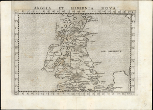
Anglia et Hibernia Nova.
$750.00
Acquire
- Digital Map Information
- Suitable for large format printing
- Full resolution TIFF file
- ICC color profile embedded
- Delivered instantly via download link
This is a handsome example of Girolamo Ruscelli's 1561 map of the British Isles. Of the maps prepared for Ruscelli's Ptolemy, it is among the most important: while most were larger, superior copies of the maps appearing in the 1548 Gastaldi Ptolemy, this map was a unique, updated work based on an English source, George Lily. (more details)
Early Glimpses of Mexico, California and the Gulf Coast.
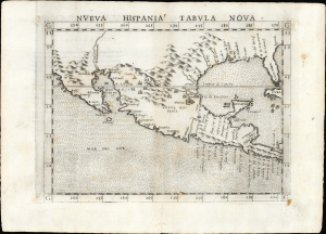
Nueva Hispania Tabula Nova.
$1,250.00
Acquire
- Digital Map Information
- Suitable for large format printing
- Full resolution TIFF file
- ICC color profile embedded
- Delivered instantly via download link
This is Girolamo Ruscelli's 1561 Nueva Hispania Tabula Nova, an early and influential map of what would become Mexico, California, Texas, and Florida. Ruscelli's work is an enlarged and improved version of the 1548 map of the same region by fellow Venetian Giacomo Gastaldi. Apart from the Gastaldi, Ruscelli's map is the earliest to focus so closely on the southern parts of what would become the United States and is one of the earliest acquirable maps to reflect Spanish exploration and colonization in the Americas. Overall, along with the map covering the East Coast north of Florida, this is among the earliest maps to focus on North America. (more details)
Among the earliest detailed maps of the coast of Sub-Saharan Africa.
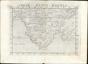
Africa Nuova Tavola.
$500.00
Acquire
- Digital Map Information
- Suitable for large format printing
- Full resolution TIFF file
- ICC color profile embedded
- Delivered instantly via download link
This is Girolamo Ruscelli's 1561 map of southern Africa, an enlarged and improved version of the 1548 map of fellow Venetian Giacomo Gastaldi. It is among the earliest detailed maps of the coast of Sub-Saharan Africa; while Münster's 1540 map presented an image of the whole continent, it lacked significant coastal detail. This map, like its Gastaldi model, is among the earliest obtainable maps to include details of both the African coastline and its river systems. (more details)
One of the Earliest Depictions of Discovery-Era India.
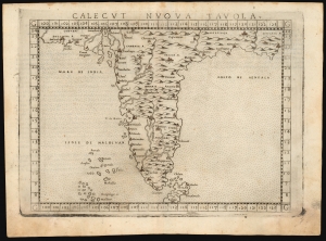
Calecut Nuova Tavola.
$400.00
Acquire
- Digital Map Information
- Suitable for large format printing
- Full resolution TIFF file
- ICC color profile embedded
- Delivered instantly via download link
This is Girolamo Ruscelli's 1561 / 1574 map of India. It is among the earliest printed, modern maps of India - most earlier maps being iterations of Claudius Ptolemy's geographical information of the 2nd century. (more details)
First Specific Copperplate Map of Brazil.
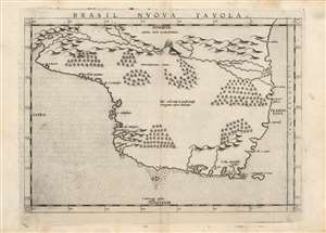
Brasil Nuova Tavola.
$650.00
Acquire
- Digital Map Information
- Suitable for large format printing
- Full resolution TIFF file
- ICC color profile embedded
- Delivered instantly via download link
This is a bold, sharp strike of Girolamo Ruscelli's 1561 map of Brazil. It is among the first detailed specific maps of any part of South America. While most of the maps in Ruscelli's edition of Ptolemy were based on those appearing in Gastaldi's 1548 Ptolemy, this map was a new composition. It is predated only by the Ramusio woodcut map of 1556, whose geography is also credited to Gastaldi, and from which much of the detail of the Ruscelli is derived. (more details)
One of the Earliest Maps of the North American East Coast.
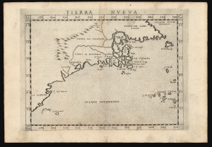
Tierra Nueva.
$1,600.00
Acquire
- Digital Map Information
- Suitable for large format printing
- Full resolution TIFF file
- ICC color profile embedded
- Delivered instantly via download link
This is Girolamo Ruscelli's 1574 map Tierra Nueva, one of the earliest maps to focus on the North American East Coast and the Canadian Maritime Provinces. (more details)
An Early Map of Western Africa.
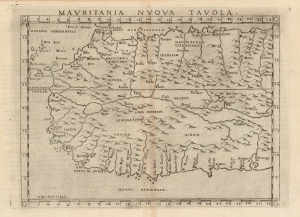
Mauritania Nuova Tavola.
$400.00
Acquire
- Digital Map Information
- Suitable for large format printing
- Full resolution TIFF file
- ICC color profile embedded
- Delivered instantly via download link
This is Girolamo Ruscelli's 1574 map of western Africa, here termed 'Mauritania' but extending south to include northwestern Africa from Gibraltar in the north to the Guinea coast in the south. The map spans from the Canary Islands in the west, eastwards to modern Tunisia and Nigeria. Ruscelli's work is an enlarged and improved version of the 1548 map of fellow Venetian Giacomo Gastaldi. (more details)
Geographical Reassessment of the eastern Sahara and the Lower Nile.
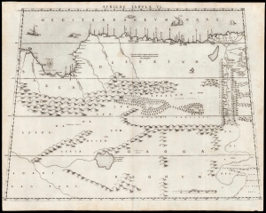
Africae Tabula VI.
$2,500.00
Acquire
- Digital Map Information
- Suitable for large format printing
- DPI: 600
- File Size: 42.73 MB
- File Type: ZIP / TIFF
- ICC color profile embedded
- Delivered instantly via download link
This elegant map of Egypt, focusing on the Lower Nile and Eastern Mediterranean coast was printed in a single edition in 1588 for Livio and Giulio Sanuto's twelve-sheet 'atlas' of Africa. Of the 16th century maps focusing north Africa, Sanuto is unique. His depiction of the continent differed sharply from any contemporaneous map, the result of his thorough reconsideration of African geography in the light of both conventional and newly available sources - marking it as a unique and underappreciated masterpiece of geographical thought. (more details)
Best 16th century map of the region around Marrakesh.
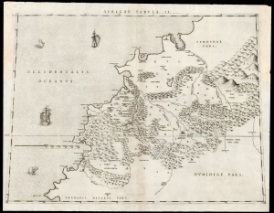
Africae Tabula II.
$2,000.00
Acquire
- Digital Map Information
- Suitable for large format printing
- DPI: 600
- File Size: 44.36 MB
- File Type: ZIP / TIFF
- ICC color profile embedded
- Delivered instantly via download link
This is Livio Sanuto's rare and beautiful 1588 map of central Morocco, focusing on Marrakesh and the area lying between the Oum Er-Rbia and the Sous Rivers. The map depicts the rugged western end of the Atlas Mountains with details drawn almost exclusively from the reports of the Berber-Andalusi traveler, diplomat, and author Johannes Leo Africanus (1494 - 1554). It is moreover a strikingly beautiful engraving, a masterwork of Livio's brother Giulio, who engraved all twelve of the maps comprising their atlas of Africa. (more details)