1851 Black Map of Egypt, Arabia and Asia Minor
EgyptAsiaMinor2-black-1851$125.00

Title
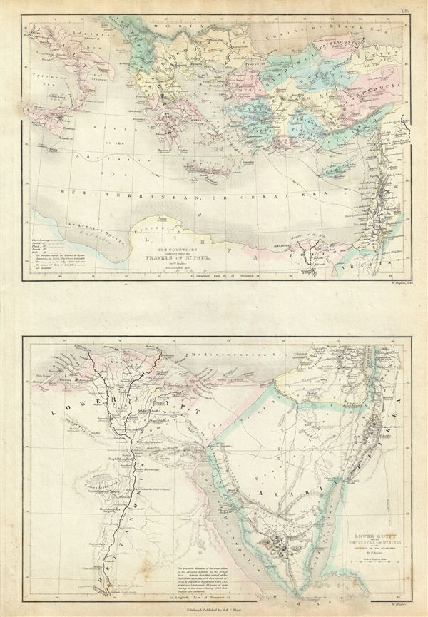
The Countries embraced within the Travels of St. Paul. Lower Egypt with the Peninsula of Mt. Sinai and the Journeys of the Israelites.
1851 (undated) 16.5 x 11 in (41.91 x 27.94 cm)
1851 (undated) 16.5 x 11 in (41.91 x 27.94 cm)
Description
This is a fine example of Adam and Charles Black's 1851 Biblical reference map of Greece, Italy, Asia Minor and Lower egypt in antiquity. The map is divided into two parts: The upper map covers the countries traveled by St. Paul, which include Italy, Greece and the Balkans and Asia Minor south as far as Arabia and egypt. The lower map covers Arabia and egypt and follows the journeys of the Israelites, including egypt, centered on the Nile River, and extending south as far as Hermopolis. Both maps feature ancient and contemporary place names, ie. Candia and Crete, for each destination - an invaluable resource or scholars of antiquity. The journeys of St. Paul are depicted on the upper map by variously dotted lines to differentiate from the first to the fifth journey. The lower map also depicts the Journeys of the Israelites from their first arrival at Kadesh and their second and third arrival and departure thereof. Throughout, the map identifies various cities, towns, rivers, mountain passes and an assortment of additional topographical details with relief shown by hachures. The upper map is hand colored in pink, green, blue and yellow pastels to define provincial boundaries. The lower map is outlined in red and green color depicting boundaries. This map was engraved by Sidney Hall for issue as plate no. LX in the 1851 edition of Black's General Atlas of the World.
CartographerS
Charles and Adam Black (fl. 1807 - present) were map and book publishers based in Edinburgh. Charles and his uncle, Adam, both of Edinburgh, Scotland, founded their publishing firm in 1807. They published a series of maps and atlases throughout the 19th century. In addition to an array of atlases, the Black firm is known for their editions of the Encyclopedia Britannica (1817 - 1826) and the first publishing of Sir Walter Scott's novels in 1854. In 1889 the A. & C. Black publishing house moved to London where it remains in operation to this day. More by this mapmaker...
Sidney Hall (1788 - 1831) was an English engraver and map publisher active in London during the late 18th and early 19th centuries. His earliest imprints, dating to about 1814, suggest a partnership with Michael Thomson, another prominent English map engraver. Hall engraved for most of the prominent London map publishers of his day, including Aaron Arrowsmith, William Faden, William Harwood, and John Thomson, among others. Hall is credited as being one of the earliest adopters of steel plate engraving, a technique that allowed for finer detail and larger print runs due to the exceptional hardness of the medium. Upon his early death - he was only in his 40s - Hall's business was inherited by his wife, Selina Hall, who continued to publish under the imprint, "S. Hall", presumably for continuity. The business eventually passed to Sidney and Selina's nephew Edward Weller, who became extremely prominent in his own right. Learn More...
Source
Black, A. and C., General Atlas Of The World, (Edinburgh) 1851.
Condition
Very good. Minor overall toning. Blank on verso. Minor foxing.
References
Rumsey 2305.072 (1854 edition). Philips (atlases) 4334.