1879 Meyer Map of Elizabethtown, New Jersey, During the American Revolution
Elizabethtown-meyer-1879$2,000.00

Title
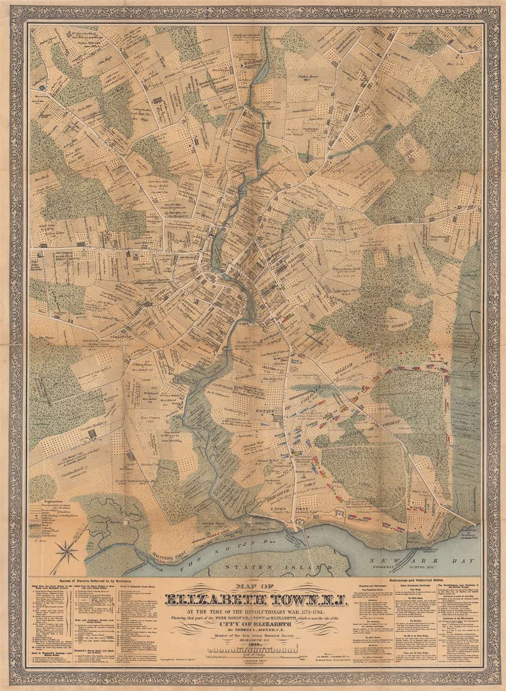
Map of Elizabethtown, N.J. at the Time of the Revolutionary War, 1775 - 1783. Showing that part of the Free Borough and Town of Elizabeth, which is now the site of the City of Elizabeth.
1879 (dated) 40 x 29.25 in (101.6 x 74.295 cm) 1 : 7200
1879 (dated) 40 x 29.25 in (101.6 x 74.295 cm) 1 : 7200
Description
This is an 1879 Ernest Meyer map of Elizabeth, New Jersey, during the American Revolution.
Historical Detail
Coverage embraces most of Union County, including Elizabeth, Westfield, and Springfield, as they appeared during the Revolutionary War (1775 - 1783). Tracts of land are identified by individual property owners, with years in parentheses identifying when documentary evidence exists for each parcel of land. Some even include a history of how the land changed hands from one owner to the next. Buildings are illustrated throughout, some identified by name, such as Liberty Hall (the residence of the governor), Allen's Tavern, and a cider mill likely owned by Cornelius Hatfield Jr. In the bottom right, British and Hessian defensive positions are marked by letters and symbols identifying specific units.Elizabeth and the American Revolution
With its proximity to British-occupied Staten Island, Elizabethtown (just Elizabeth today) endured multiple invasions and raids. The most devastating took place on January 25, 1780, in which the British burned the Presbyterian Church, the Manse, the Old Academy School, and the Courthouse. British fortifications from the 1780 invasion are marked by capital letters (A through H), including defensive works that were built to protect the army's withdrawal. The Battle of Springfield, just north of Elizabethtown, marked the last British incursion into New Jersey and the last major battle in the North, as fighting shifted to the Southern theater soon after the British defeat.Publication History and Census
This map was created and published by Ernest L. Meyer in 1879 and engraved by Joseph Shedler. We note two cataloged examples: Library of Congress and Princeton University. This map does not appear in OCLC, and we see no history of it appearing on the private market.CartographerS
Ernest Ludolph Meyer (August 26, 1828 - April 3, 1902) was a German American civil engineer, surveyor, and mapmaker. Born in Horneburg, Lower Saxony, Germany, Meyer arrived in the United States in 1851. Meyer served as City Surveyor of Elizabeth, New Jersey, for nearly thirty-five years. He planned Elizabeth's entire sewer system and devised the changes abolishing crossings at Elizabeth by the Pennsylvania and New Jersey Central railroads. Meyer's maps were recognized for their 'historical accuracy'. Meyer also designed Evergreen Cemetery in Elizabeth. More by this mapmaker...
Joseph Shedler (April 27, 1813 - December 12, 1887) was a German American lithographer and engraver. Born in Enger, Baden, Germany, it is likely that Shedler immigrated to the United States after the 1848 revolution in Germany. Shedler and his family settled in Jersey City, where he established a lithographic and engraving business. Shedler may have had as many as twelve children. Learn More...
Condition
Good. Mounted on linen. Areas of loss at some fold intersections. Accompanied by original binder.
References
Library of Congress G3814.E5S3 1879 .M4. Princeton University HMC01.1912.