1950 Junta Nacional de Turismo Pictorial Map of El Salvador
ElSalvadorPictorial-juntadeturismo-1950$250.00

Title
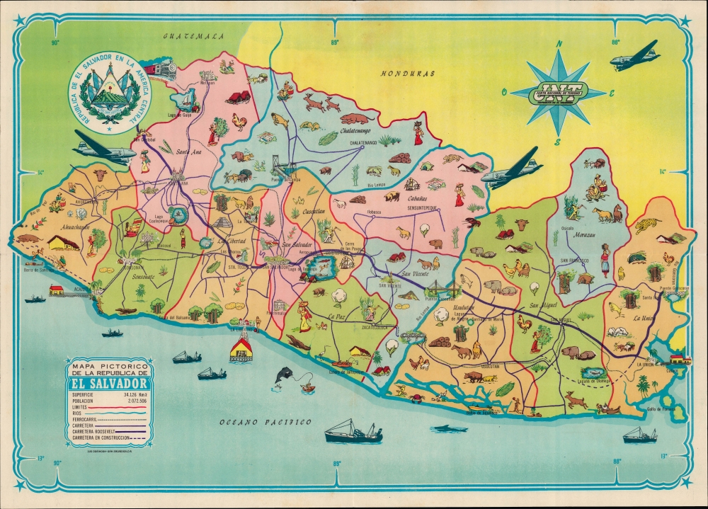
Mapa Pictorico de la Republica de El Salvador.
1950 (undated) 12 x 17 in (30.48 x 43.18 cm) 1 : 300000
1950 (undated) 12 x 17 in (30.48 x 43.18 cm) 1 : 300000
Description
A colorful c. 1950 pictorial map of El Salvador, printed by Luk Dreikorn for the country's Junta Nacional de Turismo. It highlights both the country's history and contemporary developments, such as airplanes, concrete bridges, and highways, including the Pan-American Highway.
A Closer Look
El Salvador is displayed as divided into departments, which are shaded different colors for easy distinction. Major cities, highways (existing and under construction), railroads, and waterways are indicated in accordance with the legend at bottom left. Particularly prominent is the 'Carretera Roosevelt,' a local name for the Pan-American Highway, which Franklin Delano Roosevelt championed during his administration. (Chile also named a portion of the highway after Roosevelt). Illustrations throughout represent local cultures, economies, and attractions, including beaches, Mayan ruins, and sugar cane production. Ships and sea creatures are illustrated at sea, while three airplanes appear in the upper portion of the map, hinting at the increasing use of air travel to reach El Salvador.The Pan-American Highway
Originally conceived as a railway in the late 19th century, the Pan-American Highway is a network of roads measuring about 29,800 miles in length that links the mainland nations of the Americas in a single interconnected highway system stretching from Alaska to Buenos Aires, Argentina and Santiago, Chile, except for a 54-mile break at the Darien Gap on the border of Panama and Colombia. By improving existing highways and constructing new ones, the long-discussed project was gradually brought to fruition over several decades in the early-mid 20th century, with periodic advances when efforts could be organized at an international level. One such period was the presidency of Franklin D. Roosevelt, who advocated extending the road south from Mexico, which it already traversed by the mid-1940s. Roosevelt's support for the highway's construction through Latin America was a manifestation of his 'Good Neighbor Policy.'Publication History and Census
This map was printed by Luk Dreikorn in San Salvador for the Junta Nacional de Turismo around 1950. The only other known examples of this map are held by the Biblioteca del Pavelló de la República in Barcelona and the Biblioteca AECID in Madrid.Cartographer
Lud Dreikorn (fl. c. 1949 - 1980) was a German-born publisher of maps, atlases, stamps, and books who established the first lithographic enterprise in El Salvador. Many of his works were commissioned by the government, including the Ministerío de Economía and Junta Nacional de Turismo. His sons went on to found their own printshop, Algiers Impresores, which continues to operate today. More by this mapmaker...
Condition
Very good. Light wear along original fold lines.
References
OCLC 1026104365.