This item has been sold, but you can get on the Waitlist to be notified if another example becomes available, or purchase a digital scan.
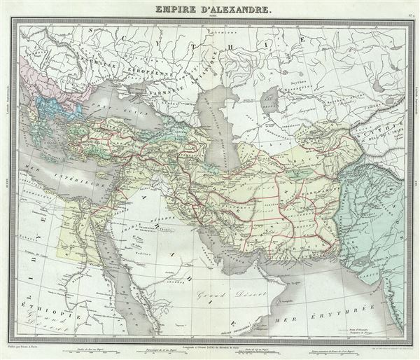
1874 Tardieu Map of Asia Minor and Arabia (The Empire of Alexander the Great)
EmpireDAlexandre-tardieu-1874$75.00

Title
Empire d'Alexandre.
1874 (undated) 15 x 17.5 in (38.1 x 44.45 cm) 1 : 13000000
1874 (undated) 15 x 17.5 in (38.1 x 44.45 cm) 1 : 13000000
Description
This is a beautiful 1874 map of the Empire of Alexander the Great by Ambroise Tardieu. It covers from Alexander's homeland in Macedonia eastwards past Asia Minor and Persia as far as India and south to include Egypt. Both the Caspian Sea and the Black Sea are included. Throughout, the map identifies various cities, towns, rivers and assortment of additional topographical details.
Tardieu created this map to illustrate the conquests of the Macedonian King Alexander III, called ‘the Great,' conqueror of the Persian empire and at just thirty, ruler of one of the largest Empires in history. Alexander the Great was undefeated in battle and is considered one of the most successful military commanders of all time. The map also notes the route for the march of Alexander, inland through Gedrosia. Alexander lost a huge number of soldiers and supplies during this march through the desert.
This map was prepared by Ambroise Tardieu and issued as plate no. 2 in his 1874 edition of Atlas Universel de Geographie Ancienne et Moderne.
CartographerS
Ambroise Tardieu (March 2, 1788 - January 17, 1841) was a prominent French cartographer and engraver operating in the late 18th and early 19th centuries. He was member of the large and prolific Tardieu family, which, for over 200 years, produced multiple skilled and active engravers. Tardieu's work is known for its beauty and accuracy as well as for its depth of detail. Tardieu's most important work is his version of John Arrowsmith's large format map of the United States, published in 1806. Ambroise Tardieu is eclipsed in fame by his son, artist and medical scholar, August Ambroise Tardieu. Ambroise Tardieu is also frequently confused with Jean Baptiste Pierre Tardieu, another unrelated French map and print engraver active in the early 19th century. More by this mapmaker...
Alexandre Aimé Vuillemin (1812 - 1880) was an engraver, publisher, and editor based in Paris, France in the middle of the 19th century. Despite a prolific publishing career, much of Vuillemin's life is shrouded in mystery. In 1852, he married Josephine Caroline Goret and they had at least one child, Ernestine Adèle Vuillemin, later in the same year. What is known is that his studied under the prominent French Auguste Henri Dufour (1798 - 1865). Vuillemin's most important work his detailed, highly decorative large format Atlas Illustre de Geographie Commerciale et Industrielle. Learn More...
Source
Furne, Jouvet et Cie Atlas Universel de Geographie Ancienne et Moderne (Paris), 1874.
Condition
Very good. Minor wear along original centerfold. Original platemark visible. Minor spotting.
References
Rumsey 4697.006 (1863 edition).