This item has been sold, but you can get on the Waitlist to be notified if another example becomes available, or purchase a digital scan.
1860 Dufour Map of Europe and The French or Napoleonic Empire
EmpireFrancais1812-dufour-1860$112.50

Title
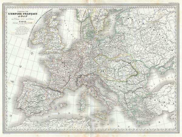
Carte de l'Empire Francais 1812.
1860 (dated) 23 x 31 in (58.42 x 78.74 cm) 1 : 5550000
1860 (dated) 23 x 31 in (58.42 x 78.74 cm) 1 : 5550000
Description
This is a scarce and beautiful 1860 elephant folio map of the Europe depicting the French Empire, issued by A. H. Dufour. The map covers the entire European continent from Ireland and southern Scandinavia south the Mediterranean Sea and east as far as the Black Sea. It depicts the extent of the First French Empire or the Napoleonic Empire at its height in 1812. The Empire included the modern day countries of France, Switzerland, Slovenia, Croatia, Belgium, Netherlands, Germany, Poland, Lithuania, parts of Italy and Austria.
In 1799, following the French Revolution, Napoleon Bonaparte staged a coup which led to Bonaparte's dictatorship and eventually (in 1804) his proclamation as Emperor, which marked the end of the republican phase of the French Revolution. The 1812 French invasion of Russia marked a turning point in Napoleon's fortunes and led to the defeat of his forces at the 'Battle of the Nations' in 1813. In 1814, a coalition of European powers defeated France and forced Napoleon into exile on the island of Elba. Napoleon's escape and final defeat at Waterloo would end 22 years of almost continuous warfare (the French Revolutionary Wars from 1792-1802, and the Napoleonic Wars, 1804-1814).
This map was prepared by Auguste-Henri Dufour and engraved by Charles Dyonette for publication plate no. 9 in Armand Le Chevalier's 1860 edition of Atlas Universel, Physique, Historique et Politique de Geographie Ancienne et Moderne.
CartographerS
Adolphe Hippolyte Dufour (1795 - 1865), also known as Auguste-Henri Dufour, was a Paris based map and atlas publisher active in the middle to late 19th century. Dufour claimed to be a student of another French cartographer, Emile Lapie. He is known to have worked with numerous other French cartographers, publishers, and engravers of the period including Andriveau-Goujon, Charles Dyonnet, and Duvotenay. His corpus includes numerous maps and atlases, the most striking of which is probably his monumental elephant folio Atlas Universel Physique, Historique et Politique Geographie Ancienne et Moderne. Dufour's student and successor was Alexandre Vuillemin. More by this mapmaker...
Charles Dyonnet (fl. c. 1822 - c. 1880) was an extremely active Paris based engraver working in the mid to late 19th century. From his offices at 220 Rue St. Jacques, Paris, Dyonnet engraved numerous maps for many of the most prominent 19th French cartographic publishers including Vuillemin, Dufour, Fremin and Duvotenay. From 1850-1861, he held the coveted position of "Graveur du Dépot de la Marine," and in this position engraved numerous French naval and military maps. Dyonnet had a detail oriented and aesthetically minded hand and is responsible from some of the most beautiful French maps to emerge during the 19th century. Learn More...
Source
Chevalier, A., Atlas Universel, Physique, Historique et Politique de Geographie Ancienne et Moderne, Paris 1860.
The 19th century French cartographer Auguste-Henri Dufour began publishing the dramatic elephant folio Atlas Universel, also occasionally titled Grand Atlas Universal, around 1855. Several editions appeared between its initial publication in the 1850s and a final run c. 1870. The 1863 and 1864 editions in particular are highly desirable among collectors because the United States and North America maps illustrate the proposed, but unrealized, state of Corona (roughly modern day Utah). The atlas contained roughly 40 maps, most of which were engraved by Louis Antoine (the maps) and Deletre (typography) under the supervision of Charles Dyonnet, official engraver of the Depot de la Marine. The Atlas Universal was published in Paris and edited by the firm of 'Paulin et le Chevalier,' 60 Rue Richelieu.
Condition
Very good. Minor wear along original fold lines. Minor spotting at places.
References
Rumsey 5020.012.