This item has been sold, but you can get on the Waitlist to be notified if another example becomes available, or purchase a digital scan.
1730 Seutter Map of Southeast England, the English Channel, London, and Normandy
EnglandChannel-seutter-1730$400.00

Title
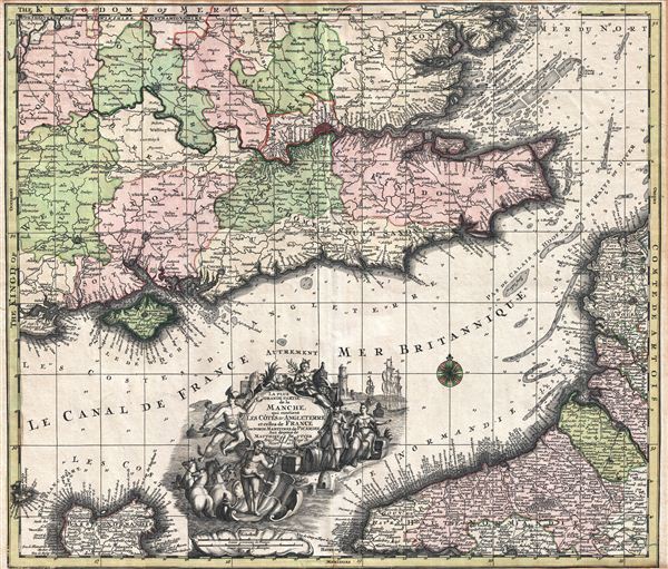
La Plus Grande Partie de la Manche, qui continent Les Cotes D'Angleterre et cells de France les Bords Maritimes de Picardie.
1730 (undated) 19 x 22.5 in (48.26 x 57.15 cm)
1730 (undated) 19 x 22.5 in (48.26 x 57.15 cm)
Description
A highly decorative c. 1730 map of the english Channel, southeastern england, and the coasts of Normandy by Matthius Seutter. The map covers southeastern england, including London and the full length of the Thames River, from Gloucester and Salisbury to the Straits of Dover and from Oxfordshire to the Isle of Wight. The coasts of Normandy are covered from Calais to Havre De Grace. Seutter's map combines elements of both nautical charts and traditional maps, with depth soundings and shading to indicate undersea dangers throughout the english Channel, North Sea, and Straits of Dover. An elaborate allegorical title cartouche appears at bottom center. The cartouche features Greek deities including Poseidon and Hermes, as well as merchants, honey bees, and trade vessels.
This map first appeared in various Seutter composite atlases in the 1730s. The present example is exceptionally vivid, suggesting an early impression from the plate. The plate was subsequently updated and reused by Seutter's successor, Conrad Lotter, in the 1770s. Most latter impressions are extremely weak due to plate overuse.
This map first appeared in various Seutter composite atlases in the 1730s. The present example is exceptionally vivid, suggesting an early impression from the plate. The plate was subsequently updated and reused by Seutter's successor, Conrad Lotter, in the 1770s. Most latter impressions are extremely weak due to plate overuse.
Cartographer
Matthäus Seutter (1678 - 1757) was one of the most important and prolific German map publishers of the 18th century. Seutter was born the son of a goldsmith but apprenticed as a brewer. Apparently uninspired by the beer business, Seutter abandoned his apprenticeship and moved to Nuremberg where he apprenticed as an engraver under the tutelage of the prominent J. B. Homann. Sometime in the early 1700s Seutter left Homann to return to Augsburg, where he worked for the prominent art publisher Jeremiad Wolff (1663 - 1724), for whom he engraved maps and other prints. Sometime around 1717 he established his own independent cartographic publishing firm in Augsburg. Though he struggled in the early years of his independence, Seutter's engraving skill and commitment to diversified map production eventually attracted a substantial following. Most of Seutter's maps are heavily based upon, if not copies of, earlier work done by the Homann and De L'Isle firms. Nonetheless, by 1731/32 Seutter was one of the most prolific publishers of his time and was honored by the German Emperor Karl VI who gave him the title of Imperial Geographer, after which most subsequent maps included the Avec Privilege designation. Seutter continued to publish until his death, at the height of his career, in 1757. Seutter had two engraver sons, Georg Matthäus Seutter (1710 - 173?) and Albrecht Carl Seutter (1722 - 1762). Georg Matthäus quit the business and relocated to Woehrdt in 1729 (and probably died shortly thereafter), leaving the family inheritance to his wastrel brother Albrecht Carl Seutter, who did little to advance the firm until in own death in 1762. Following Albrecht's death, the firm was divided between the established Johann Michael Probst (1727 - 1776) firm and the emerging firm of Tobias Conrad Lotter. Lotter, Matthäus Seutter's son-in-law, was a master engraver and worked tirelessly on behalf of the Suetter firm. It is Lotter, who would eventually become one of the most prominent cartographers of his day, and his descendants, who are generally regarded as the true successors to Matthäus Seutter. (Ritter, M. Seutter, Probst and Lotter: An Eighteenth-Century Map Publishing House in Germany., "Imago Mundi", Vol. 53, (2001), pp. 130-135.) More by this mapmaker...
Condition
Very good. Original centerfold. Margins narrow. Blank on verso.