1800 Bowles and Carven Map Folding Road Map of England and Wales
EnglandWales-bowles-1800$750.00

Title
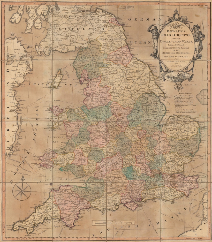
Bowles's road director through England and Wales; being a new and comprehensive display of the roads and distances from town to town, and of each remarkable place from London.
1800 (dated) 23.5 x 20.5 in (59.69 x 52.07 cm) 1 : 1235520
1800 (dated) 23.5 x 20.5 in (59.69 x 52.07 cm) 1 : 1235520
Description
An impressive 1800 Bowles and Carver map highlighting the system of roads of England and Wales, including the dense network emanating from London.
A Closer Look
Taking in all of England and Wales, with portions of Scotland and Ireland, the map is expertly hand-colored with counties of England and Wales shaded to easily distinguish them. Distances (in miles) of stretches of roads between towns are noted, while the distance of towns and cities from London is indicated with a circled number. Aside from principal roads, often turnpikes, great roads and lesser roads are also indicated, as are ferry services to the Isle of Man, Ireland, and the Continent with distance marked in leagues. An intricate title cartouche includes drivers, muskets, and a vignette of a carriage on the move.Historical Context
In the decades before this map's publication, the road system of Britain expanded considerably, primarily through the establishment of turnpike trusts financed through debts that were repaid by tolls. This approach was wildly successful for constructing a national network of wide, straight roads connecting large towns and cities, which facilitated trade and travel. However, the tolls came to be seen as onerous by travelers and were so resented that they even led to riots, especially in Wales, by the mid-19th century. As a result, the turnpike system was gradually undone (also known as detrunking) and local governments generally took over administration of the highways and turnpikes, with oversight and funding from Parliament.Publication History and Census
This map was produced and published by the London-based firm Bowles and Carver in 1800. It was issued with some regularity around the turn of the 19th century, though it is now a rare map in any edition (in the 1830s, maps of the same title were produced by James Wyld). The OCLC lists 1796 and 1804 editions and we have located examples from 1802 and 1811 in institutional collections, but there are no other known examples of the 1800 edition in either institutional collections or on the market.Cartographer
The Bowles Family (fl. c. 1714 - 1832) were publishers and map sellers active in London from c. 1714 to c. 1832. The firm, under Thomas Bowles (fl. 1714 - 1763), John Bowles (1701 - 1779), Carrington Bowles (1724 - 1793), and as Bowles and Carver (fl. 1794 - 1832), produced a massive corpus of work that included numerous atlases, pocket maps, and wall maps. The Bowles publishing tradition was kept alive for four generations, starting with Thomas Bowles, a print engraver active in the late 17th century. His son, Thomas Bowles II, produced the firm's first maps at St. Paul's Churchyard, London. Thomas's brother, John Bowles (a.k.a. 'Old John Bowles' or 'Black Horse Bowles'), was also an active publisher established at no. 13 Cornhill. He is credited as one of the first publishers of William Hogarth's works. There, John's son, Carrington Bowles, was introduced to the trade. Carrington took over the Cornhill bookshop and eventually merged it with his uncle's shop in St. Paul's Churchyard. On Carrington's 1793 death, the business was passed to his son Henry Carrington Bowles (1763 - 1830), who partnered with his father's former apprentice Samuel Carver (1756 - 1841), renaming the firm 'Bowles and Carver'. Under this imprint, the firm continued to publish maps and atlases until 1832. Henry Carrington Bowles died in 1830, but Samuel Carver, himself in advanced years and poor health, kept it going for another 2 years before closing the business. More by this mapmaker...
Condition
Very good. Dissected and laid on linen. Periodic spots of soiling. Accompanied by original slipcase.
References
OCLC 316376711.