This item has been sold, but you can get on the Waitlist to be notified if another example becomes available, or purchase a digital scan.
1796 Cary Folding Case Map of England & Wales
EnglandWales-cary-1793$200.00

Title
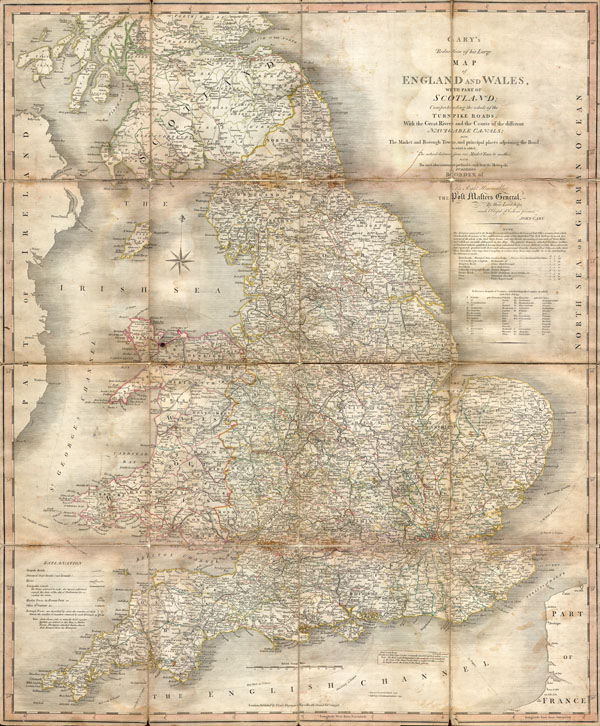
Cary’s Reduction of his Large Map of England and Wales, with part of Scotland; Comprehending the whole of the Turnpike Roads, With the Great Rivers and the Course of the different Navigable Canals: also The Market and Borough Town, and principal places adjoining the Road. To which is added, the Actual distance from one Market Town to another, with The exact admeasurement prefixed to each from the Metropolis. Published by Order of, and Dedicated with Permission to The Right Honorable the Post Masters General, by their Lordships, much Obliged & Obedient Servant, John Cary.
1796 (dated) 30 x 24 in (76.2 x 60.96 cm)
1796 (dated) 30 x 24 in (76.2 x 60.96 cm)
Description
An important 1796 Case Map of England, Wales and the Southern part of Scotland by John Cary. This is in fact a reduction of Cary's seminal and enormous large format map of England and Wales produced a few years previously. Map depicts the region in impressive detail with special attention to matters of trade and transport – roads, tolls, bridges, canals, etc. Dissected into 16 sheets and mounted on linen. Dated at base, Feb 20, 1796.
Cartographer
John Cary (1754 - 1835) was a London based cartographer active in the early part of the 19th century. Ronald Vere Tooley, the prominent English map historian, writes of Cary, "As an engraver he was elegant and exact with fine clear lettering and great delicacy of touch." Cary began his work as an engraver, cartographer, and globe maker in 1776 with his New and Correct English Atlas. This important atlas represented a new phase in cartography where accuracy and detail rose in prominence over the decorative embellishments of the 18th century. This change was indicative of the times when travel and commerce were expanding globally as never before. Cary's mastery of both engraving and cartography resulted in a series of seminal works that redefined mapmaking in the early 19th century. His stupendous Cary's New Universal Atlas, published in 1808, set the standard for all cartographers who followed. Cary reissued this seminal atlas in 1811, 1819, 1824, 1828, 1833, 1836 and 1844. Cary also did considerable work on the English Ordinance Survey prior to 1805. His cartographic work particularly inspired the Edinburgh school of cartography as represented by John Pinkerton and John Thomson. In America, Cary's work was used as the basis for Tanner's important New American Atlas. Cary's last published atlas appeared posthumously in 1844, however, by 1850 Cary's work was being carried on by his sons and other well-known cartographers including James Wyld, John Tallis & Company, and Crutchley. More by this mapmaker...
Condition
Good condition. Some age toning, especially on the folds. Dissected into 16 sections and mounted on linen for easy folding – as issues. Reinforcement of original linen backing on verso. Minor water damage to verso.