1835 Williams Map of a Proposed Route for Canal Between Lakes Erie and Ontario
ErieOntario-williams-1835$450.00

Title
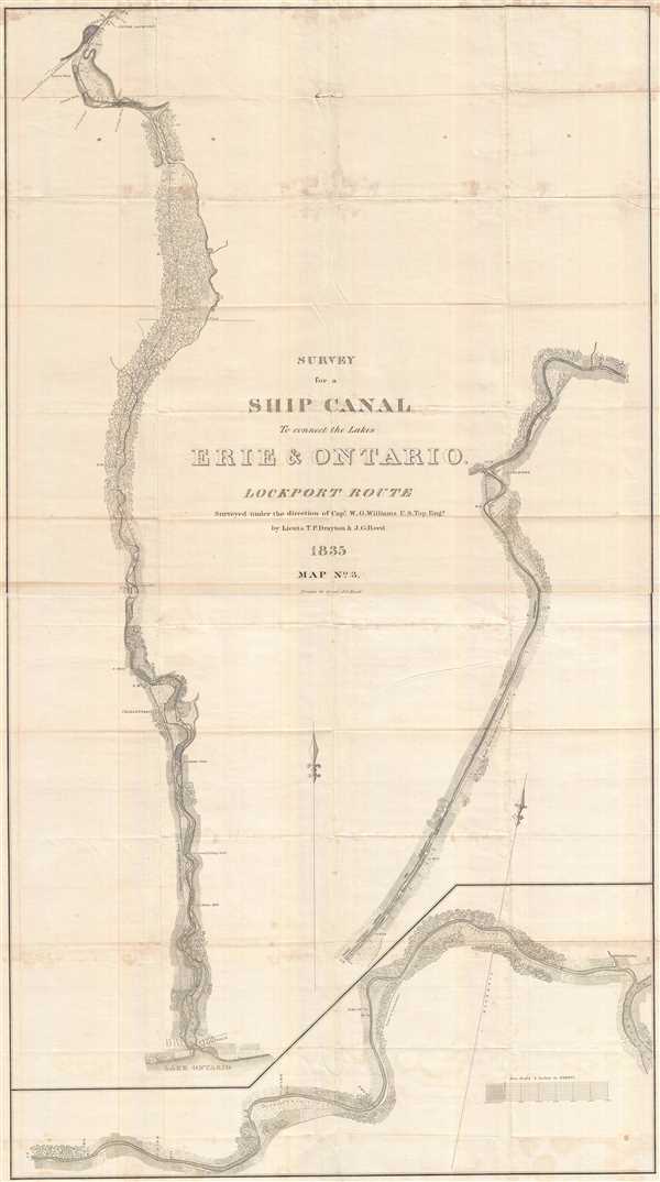
Survey for a Ship Canal to connect the Lakes Erie and Ontario. Lockport Route.
1835 (dated) 51 x 29 in (129.54 x 73.66 cm) 1 : 15840
1835 (dated) 51 x 29 in (129.54 x 73.66 cm) 1 : 15840
Description
This is a stunning and important 1835 William G. Williams map of Line No. 5 for the proposed canal connecting Lake Erie and Lake Ontario. The map depicts a route 'from the mouth of Eighteen-mile creek to the outlet of the Tonnewanta, on the Niagara [R]iver.' The survey was requested by a member of the 'United States Legislature' and a 'committee of gentlemen from Lockport' and undertaken at their expense. Drawn in three segments, the proposed route begins at Kempville and follows Eighteen-mile creek to Lockport, where it meets the Erie Canal and appears to run parallel to it, until joining Tonnawanta Creek and finally the Niagara River at Tonnawanta, traversing a total distance of 32 miles.
Each segment is illustrated in detail, presenting both fields and forests as well as landmarks, such as Vanhorn's Fullling Mill, roads, and towns. Distance is noted on the map, along with several other unknown notations.
This map was drawn by Lieutenant J.G. Reed, U.S. Topographical Engineers.
Each segment is illustrated in detail, presenting both fields and forests as well as landmarks, such as Vanhorn's Fullling Mill, roads, and towns. Distance is noted on the map, along with several other unknown notations.
This map was drawn by Lieutenant J.G. Reed, U.S. Topographical Engineers.
Cartographer
William G. Williams (1801-1846) served in the U.S. Army from 1820 until 1846. He graduated from the U.S. Military Academy at West Point and, after graduation, served on topographical cut, eventually reaching the rank of Captain. He oversaw the survey for the proposed canal around the Falls of Niagara, New York and on Lake Champlain, New York. He served as Superintendent of Survey of Northwestern Lakes from 1841-1846. The Mexican-American War broke out in 1846, where he served as the Chief Topographical Engineer of the Army commanded by Major General Taylor until September 21, 1846 when, fighting in the Battle of Monterey, he was mortally wounded and died of his wounds. He is buried in Buffalo, New York. More by this mapmaker...
Condition
Very good. Even overall toning. Light transferrence. Blank on verso.
References
OCLC 22701639.