1831 Lapie Map of the Peninsula including Spain and Portugal
EspagnePortugal-lapie-1829$175.00

Title
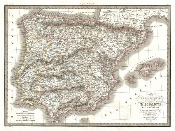
Carte de la Peninsule Comprenant l'Espagne et la Portugal.
1831 (dated) 16.5 x 22 in (41.91 x 55.88 cm)
1831 (dated) 16.5 x 22 in (41.91 x 55.88 cm)
Description
A fine first edition example of M. Lapie's 1831 map of the Iberia or Spain and Portugal. The map covers all of Spain and Portugal from France to the Mediterranean Sea and from the Atlantic to the Balearic Islands. During this period Portugal on the cusp of the War of the Two Brothers. In 1826, Peter IV of Portugal abdicated his thrown in favor of his seven year old daughter Maria da Gloria, on the condition that she marry her uncle (Peter's brother) Miguel. Miguel deposed Maria and proclaimed himself King, which led to the Liberal Wars, and eventually resulted in Miguel being forced to abdicate and go into exile, and Maria II being proclaimed Queen. During this same period, in Spain, the death of Ferdinand VII also saw his daughter, Isabella II, an infant at the time, proclaimed Queen. This would also lead to the First Carlist War in Spain from 1833-1839.
This map was engraved by Armand Joseph Lallemand as plate no. 24 in the first edition of M. Lapie's important Atlas Universel. This map, like all maps from the Atlas Universel features an embossed stamp from the Lapie firm.
This map was engraved by Armand Joseph Lallemand as plate no. 24 in the first edition of M. Lapie's important Atlas Universel. This map, like all maps from the Atlas Universel features an embossed stamp from the Lapie firm.
CartographerS
Pierre M. Lapie (fl. 1779 - 1850) and his son Alexandre Emile Lapie (fl. 1809 - 1850) were French cartographers and engravers active in the early part of the 19th century. The Lapies were commissioned officers in the French army holding the ranks of Colonel and Capitan, respectively. Alexander enjoyed the title of "First Geographer to the King", and this title appears on several of his atlases. Both father and son were exceptional engravers and fastidious cartographers. Working separately and jointly they published four important atlases, an 1811 Atlas of the French Empire (Alexander), the 1812 Atlas Classique et Universel (Pierre), the Atlas Universel de Geographie Ancienne et Modern (joint issue), and the 1848 Atlas Militaire (Alexander). They also issued many smaller maps and independent issues. All of these are products of exceptional beauty and detail. Despite producing many beautiful maps and atlases, the work of the Lapie family remains largely underappreciated by most modern collectors and map historians. The later 19th century cartographer A. H. Dufour claimed to be a student of Lapie, though it is unclear if he was referring to the father or the son. The work of the Lapie firm, with its precise engraving and informational density, strongly influenced the mid-19th century German commercial map publishers whose maps would eventually dominate the continental market. More by this mapmaker...
Armand Joseph Lallemand (c. 1810 - 1871) was an engraver and map publisher based in Paris during the mid-19th century. Most of Lallemand's work focused on landscapes and building vies, though he did take part in a few cartographic ventures, including the production of an atlas with Alexandre Emile Lapie and several tourist pocket maps of Paris. Learn More...
Source
Lapie, M., Atlas Universel de Geographie. Ancienne et Moderne, precede d'un Abrege de Geographic Physique et Historique…, 1829. (Rumsey identifies this as the first edition of Lapie's Atlas Universel. In all known examples, the title page is dated 1829 while the maps are dated variously to 1833 - suggesting that the first issue of this atlas was 1833, not 1829.)
Condition
Very good. Original platemark visible. Blank on verso. Original centerfold.
References
Rumsey 2174.024. Phillips (Atlases) 754, 765.